
| ERIK NIELSEN INTL WHITEHORSE YT |
| |
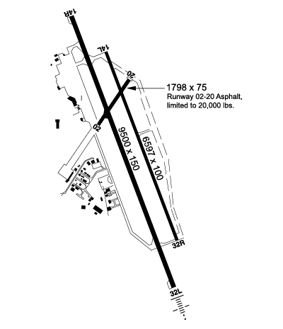
| Lat: N 6042.6 Long: W 13504.0 Elev: 2317 Var: -19 Longest Runway: 9500 | ||
| Ground: 121.9 Tower: 118.3 | ||
| ||||||||||||||||||||||||||||||||||||||||||||
| ||||||||||||||||||||||||||||||||||||||||||||
| Rwy | Rwy | |||||||
| 1798x75 | 1798' | 1798x75 | 1798' | |||||
| 4018x80 | 4018' | 4018x80 | 4018' | |||||
| 9500x150 | 8649' | 9500x150 | 8099' | |||||
| Runway ID | Single Wheel | Double Wheel | Double Tandem Wheel | Dual Double Wheel |
| 01/19 | N/A | N/A | N/A | N/A |
| 13L/31R | N/A | N/A | N/A | N/A |
| 13R/31L | N/A | N/A | N/A | N/A |
| These numbers are Advisory and are not limits. The Airport Manager should have more accurate Weight Limits | ||||
 Airport Diagram might not be current. | |
| Facility Name: | WHITEHORSE/ERIK NIELSEN INTL |
| City Name: | WHITEHORSE |
| County: | YUKON TERR, CANADA |
| State abbrev: | |
| State Name: | |
| Ownership: | PRIVATELY OWNED |
| Use: | OPEN TO THE PUBLIC |
| Owner's Name: | GOVT OF YUKON |
| Address: | |
| Owner's Phone: | 867-667-8440 |
| Manager's Name: | |
| Address: | |
| Phone: | |
| FAA Region: | |
| FAA Field Office: | NONE |
| Date | Sunrise | Sunset |
|---|---|---|
| 04/25/24 Thursday | 6:09 | 21:49 |
| 04/26/24 Friday | 6:06 | 21:52 |
| 04/27/24 Saturday | 6:03 | 21:54 |
| 04/28/24 Sunday | 6:00 | 21:57 |
| 04/29/24 Monday | 5:57 | 21:59 |
| 04/30/24 Tuesday | 5:54 | 22:02 |
| 05/01/24 Wednesday | 5:51 | 22:04 |
| 05/02/24 Thursday | 5:49 | 22:07 |
| 05/03/24 Friday | 5:46 | 22:10 |
| 05/04/24 Saturday | 5:43 | 22:12 |
| 05/05/24 Sunday | 5:40 | 22:15 |
| 05/06/24 Monday | 5:38 | 22:17 |
| 05/07/24 Tuesday | 5:35 | 22:20 |
| 05/08/24 Wednesday | 5:32 | 22:22 |
| Airport Attendance Schedule | |
| Airport Status | OPERATIONAL (This Status can change at any time - please check NOTAMS) |
| Airport Lighting Schedule | |
| Airport Storage Available | NONE |
| Extra Services Available | NONE |
| Wind Indicator | NONE |
| Control Tower | YES |
| CTAF Frequency | |
| Unicom Frequency | |
| Rotating Beacon Color | |
| Segmented Circle | NO |
| Landing Fee |
| Airport Inspected | No Inspection Data Available performed by the OWNER |
| Inspection Date | Unknown |
| Type of Fuel Available | Grade 100LL, JET A (freeze point -40C) |
| Airframe Repair Service | MINOR |
| Power Plant Repair Service | MINOR |
| Latitude | N6042.6 |
| Longitude | W13504.0 (ESTIMATED) |
| Arpt Elevation | 2317ft (ESTIMATED) |
| Magnetic Variation | 25E |
| 0 miles SE | of WHITEHORSE |
| Traffic Pattern Altitude | |
| Sectional Chart |
| Operations (Reported) | Yearly | Avg. Daily |
|---|---|---|
| General Aviation Transient | 0 | 0 |
| General Aviation Local | 0 | 0 |
| Air Taxi | 0 | 0 |
| Commerical | 0 | 0 |
| Commuter | 0 | 0 |
| Military | 0 | 0 |
| Aircraft based on Field | |
|---|---|
| General Aviation Singles | 0 |
| General Aviation Multi | 0 |
| Jet Aircraft | 0 |
| General Aviation Helicopters | 0 |
| Military Aircraft | 0 |
| Gliders | 0 |
| Ultralights | 0 |
| FSS on field | NO |
| FSS tie-in | WHITEHORSE |
| FSS Phone | |
| Who issues Notams | CYXY |
| Notam D service at airport | No |
| ARTCC Name | EDMONTON |
| Airport Certification | |
| Aircraft Rescue & Firefighting Index | None |
| Airport of Entry | No |
| Custom Landing Rights | No |
| Joint Civil/Military | No |
| Military Landing rights | No |
| TWY G UNCONTROLLED. |
| RY 1/19 NO WINTER MAINTENANCE. |
| PPR FOR FIXED WING ACFT TKOF &LDG OF MOVEMENT AREAS. |
Airport Communications & Frequencies:
|
| Runway: 01 | Runway: 19 | ||
| Approach: | Approach: | ||
| Pattern: | Pattern: | ||
| Markings: | Markings: | ||
| Marking Condition: | Marking Condition: | ||
| Arresting Dev: | Arresting Dev: | ||
| Lat & Long: | Lat. & Long.: | ||
| Elev: | N/A | Elev: | N/A |
| TCH: | TCH: | ||
| Visual Glide Path: | Visual Glide Path: | ||
| Displaced Threshold: | No | Displaced Threshold: | No |
| Touchdown Zone: | NO | Touchdown Zone: | NO |
| Touchdown Elev.: | Touchdown Elev.: | ||
| Visual Glide Slope: | Visual Glide Slope: | ||
| RVR Equipment: | RVR Equipment: | ||
| RVV Equipment: | NO | RVV Equipment: | NO |
| Approach Lights: | Approach Lights: | ||
| REIL: | NO | REIL: | NO |
| Centerline Lights: | NO | Centerline Lights: | NO |
| Touchdown lights: | NO | Touchdown lights: | NO |
| Runway Category: | Runway Category: | ||
| Declared Distances: | Declared Distances: |
| Runway: 13L | Runway: 31R | ||
| Approach: | Approach: | ||
| Pattern: | Pattern: | ||
| Markings: | Markings: | ||
| Marking Condition: | Marking Condition: | ||
| Arresting Dev: | Arresting Dev: | ||
| Lat & Long: | Lat. & Long.: | ||
| Elev: | N/A | Elev: | N/A |
| TCH: | TCH: | ||
| Visual Glide Path: | Visual Glide Path: | ||
| Displaced Threshold: | No | Displaced Threshold: | No |
| Touchdown Zone: | NO | Touchdown Zone: | NO |
| Touchdown Elev.: | Touchdown Elev.: | ||
| Visual Glide Slope: | Visual Glide Slope: | ||
| RVR Equipment: | RVR Equipment: | ||
| RVV Equipment: | NO | RVV Equipment: | NO |
| Approach Lights: | Approach Lights: | ||
| REIL: | NO | REIL: | NO |
| Centerline Lights: | NO | Centerline Lights: | NO |
| Touchdown lights: | NO | Touchdown lights: | NO |
| Runway Category: | Runway Category: | ||
| Declared Distances: | Declared Distances: |
| Runway: 13R | Runway: 31L | ||
| Approach: | Approach: | ||
| Pattern: | Pattern: | ||
| Markings: | Markings: | ||
| Marking Condition: | Marking Condition: | ||
| Arresting Dev: | Arresting Dev: | ||
| Lat & Long: | Lat. & Long.: | ||
| Elev: | N/A | Elev: | N/A |
| TCH: | TCH: | ||
| Visual Glide Path: | Visual Glide Path: | ||
| Displaced Threshold: | 851 feet | Displaced Threshold: | 1401 feet |
| Touchdown Zone: | NO | Touchdown Zone: | NO |
| Touchdown Elev.: | Touchdown Elev.: | ||
| Visual Glide Slope: | Visual Glide Slope: | ||
| RVR Equipment: | RVR Equipment: | ||
| RVV Equipment: | NO | RVV Equipment: | NO |
| Approach Lights: | ODALS - omnidirectional approach lighting system | Approach Lights: | SSALR - simplified short approach lighting system with runway alignment indicator lights |
| REIL: | YES | REIL: | YES |
| Centerline Lights: | NO | Centerline Lights: | NO |
| Touchdown lights: | NO | Touchdown lights: | NO |
| Runway Category: | Runway Category: | ||
| Declared Distances: | Declared Distances: |
Thanks for using FltPlan.com
all rights reserved © 1999-2024 by Flight Plan LLC
