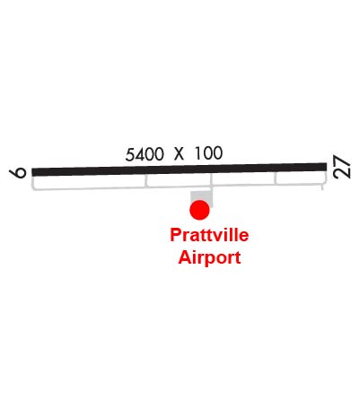
| PRATTVILLE - GROUBY FIELD PRATTVILLE AL |
| |
| Lat: N 3226.3 Long: W 08630.8 Elev: 225 Var: +03 Longest Runway: 5400 | ||
| AWOS: 118.02 CTAF: 122.8 | ||
| |||||||||||||||||||||||
| |||||||||||||||||||||||
| |||||||||||||||||||||||
| Rwy | Rwy | |||||||
| 5400x100 | 5400' | 5400x100 | 5400' | |||||
| Runway ID | Single Wheel | Double Wheel | Double Tandem Wheel | Dual Double Wheel |
| 09/27 | 30,000 | N/A | N/A | N/A |
| These numbers are Advisory and are not limits. The Airport Manager should have more accurate Weight Limits | ||||
 Airport Diagram might not be current. | |
| Facility Name: | PRATTVILLE - GROUBY FLD |
| City Name: | PRATTVILLE |
| County: | AUTAUGA |
| State abbrev: | AL |
| State Name: | ALABAMA |
| Ownership: | PUBLICLY OWNED |
| Use: | OPEN TO THE PUBLIC |
| Owner's Name: | PRATTVILLE ARPT AUTH.; BILL HAMBURGER, CHAIRMAN. |
| Address: | 1450 AVIATION WAY |
| PRATTVILLE, AL 36067 | |
| Owner's Phone: | 334-730-3458 |
| Manager's Name: | GENTRY SMITH |
| Address: | 1450 AVIATION WAY |
| PRATTVILLE, AL 36067 | |
| Phone: | 334-850-1013; AFT HRS PHONE 334-730-3458 |
| FAA Region: | SOUTHERN |
| FAA Field Office: | JAN |

| Date | Sunrise | Sunset |
|---|---|---|
| 09/24/21 Friday | 6:35 | 18:40 |
| 09/25/21 Saturday | 6:36 | 18:39 |
| 09/26/21 Sunday | 6:37 | 18:38 |
| 09/27/21 Monday | 6:37 | 18:36 |
| 09/28/21 Tuesday | 6:38 | 18:35 |
| 09/29/21 Wednesday | 6:39 | 18:34 |
| 09/30/21 Thursday | 6:39 | 18:32 |
| 10/01/21 Friday | 6:40 | 18:31 |
| 10/02/21 Saturday | 6:41 | 18:30 |
| 10/03/21 Sunday | 6:41 | 18:28 |
| 10/04/21 Monday | 6:42 | 18:27 |
| 10/05/21 Tuesday | 6:43 | 18:26 |
| 10/06/21 Wednesday | 6:43 | 18:25 |
| 10/07/21 Thursday | 6:44 | 18:23 |
| Airport Attendance Schedule | APR-OCT 7 Days A Week 0800-1800, NOV-MAR 7 Days A Week 0800-1700 |
| Airport Status | OPERATIONAL (This Status can change at any time - please check NOTAMS) |
| Airport Lighting Schedule | ACTVT REIL 9 & 27; MIRL RWY 09/27- CTAF. |
| Airport Storage Available | Tie Downs |
| Extra Services Available | Flight Instruction, Aircraft Rental |
| Wind Indicator | YES - (lighted) |
| Control Tower | NO |
| CTAF Frequency | 122.800 |
| Unicom Frequency | 122.800 |
| Rotating Beacon Color | CLEAR-GREEN (Light Land Airport) |
| Segmented Circle | NO |
| Landing Fee | NO |
| Airport Inspected | STATE - performed by STATE AERONAUTICAL PERSONNEL |
| Inspection Date | 11/16/2020 |
| Type of Fuel Available | Grade 100LL, JET A; -10100LL FUEL 24 HR CREDIT CARD SVC AVBL. |
| Airframe Repair Service | MAJOR |
| Power Plant Repair Service | MAJOR |
| Latitude | N3226.3 |
| Longitude | W08630.8 (ESTIMATED) |
| Arpt Elevation | 224ft (SURVEYED) |
| Magnetic Variation | 03W |
| 3 miles SW | of PRATTVILLE |
| Traffic Pattern Altitude | |
| Sectional Chart | ATLANTA |
| Operations (Reported) | Yearly | Avg. Daily |
|---|---|---|
| General Aviation Transient | 15193 | 42 |
| General Aviation Local | 6327 | 17 |
| Air Taxi | 113 | 0 |
| Commerical | 0 | 0 |
| Commuter | 0 | 0 |
| Military | 163 | 0 |
| Aircraft based on Field | |
|---|---|
| General Aviation Singles | 29 |
| General Aviation Multi | 4 |
| Jet Aircraft | 0 |
| General Aviation Helicopters | 0 |
| Military Aircraft | 0 |
| Gliders | 0 |
| Ultralights | 0 |
| FSS on field | NO |
| FSS tie-in | ANNISTON |
| FSS Phone | 1-800-WX-BRIEF |
| Who issues Notams | ANB |
| Notam D service at airport | YES |
| ARTCC Name | ATLANTA |
| Airport Certification | |
| Aircraft Rescue & Firefighting Index | None |
| Airport of Entry | No |
| Custom Landing Rights | No |
| Joint Civil/Military | No |
| Military Landing rights | YES |
| NATIONAL PLAN OF INTEGRATED AIRPORT SYSTEMS (NPIAS) |
| GRANT AGREEMENTS UNDER FAAP/ADAP/AIP |
| ASSURANCES PURSUANT TO TITLE VI, CIVIL RIGHTS ACT OF 1964 |
| GCO AVBL ON FREQ 121.725. |
| FOR CD IF UNA VIA GCO CTC ATLANTA ARTCC AT 770-210-7692. |
| FBO PHONE 334-361-0060 |
Airport Communications & Frequencies:
| |||||||||||||||||
| Runway: 09 | Runway: 27 | ||
| Mag heading: | 92° | Mag heading: | 272° |
| Rwy Slope: | -.50% Down | Rwy Slope: | .50% Up |
| Approach: | Approach: | ||
| Pattern: | Left Traffic | Pattern: | Left Traffic |
| Markings: | NONPRECISION INSTRUMENT | Markings: | NONPRECISION INSTRUMENT |
| Marking Condition: | GOOD | Marking Condition: | GOOD |
| Arresting Dev: | Arresting Dev: | ||
| Lat & Long: | N3226.3 W08631.3 | Lat. & Long.: | N3226.3 W08630.2 |
| Elev: | 224.8 ft. MSL | Elev: | 198.0 ft. MSL |
| TCH: | 62 ft. AGL | TCH: | 45 ft. AGL |
| Visual Glide Path: | 4.00 degrees | Visual Glide Path: | 3.00 degrees |
| Displaced Threshold: | No | Displaced Threshold: | No |
| Touchdown Zone: | YES | Touchdown Zone: | YES |
| Touchdown Elev.: | 224.9 feet | Touchdown Elev.: | 213.0 feet |
| Visual Glide Slope: | 4-Light PAPI on LEFT side of Runway; OTS INDEFLY. | Visual Glide Slope: | 4-Light PAPI on LEFT side of Runway |
| RVR Equipment: | RVR Equipment: | ||
| RVV Equipment: | NO | RVV Equipment: | NO |
| Approach Lights: | Approach Lights: | ||
| REIL: | YES | REIL: | YES |
| Centerline Lights: | NO | Centerline Lights: | NO |
| Touchdown lights: | NO | Touchdown lights: | NO |
| Runway Category: | Runway with a Non-precision Approach having visibility minimums greater than 3/4 mile | Runway Category: | Runway with a Visual Approach |
| Declared Distances: | Declared Distances: | ||
| Obstructions: | TREES | Obstructions: | TREES |
| Marked: | NOT Marked/Lighted | Marked: | NOT Marked/Lighted |
| Clearance slope: | 18:1 | Clearance slope: | 14:1 |
| Obstruction height: | 49 feet AGL | Obstruction height: | 9 feet AGL |
| Dist. from runway: | 1129 feet | Dist. from runway: | 328 feet |
| Centerline offset: | 73 left of centerline | Centerline offset: | 134 feet right of centerline |
| Comments: | Comments: |
Thanks for using FltPlan.com
all rights reserved © 1999-2021 by Flight Plan LLC