
| JAKE ARNER MEMORIAL LEHIGHTON PA |
| |
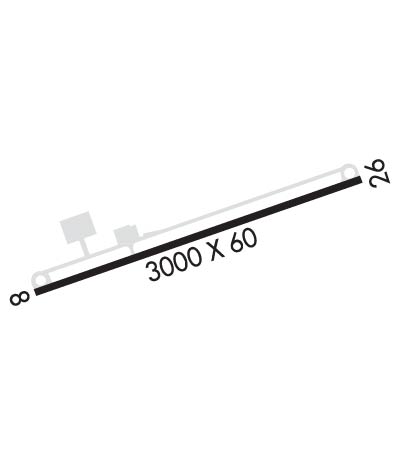
| Lat: N 4048.6 Long: W 07545.7 Elev: 534 Var: +12 Longest Runway: 3000 | ||
| AWOS: 119.35 CTAF: 123.05 | ||
| ||||||||||||||||||||||||||||||||
| ||||||||||||||||||||||||||||||||
| ||||||||||||||||||||||||||||||||
| ||||||||||||||||||||||||||||||||
| ||||||||||||||||||||||||||||||||
| Rwy | Rwy | |||||||
| 3000x60 | 3000' | 3000x60 | 3000' | |||||
| Runway ID | Single Wheel | Double Wheel | Double Tandem Wheel | Dual Double Wheel |
| 08/26 | 12,500 | N/A | N/A | N/A |
| These numbers are Advisory and are not limits. The Airport Manager should have more accurate Weight Limits | ||||
 Airport Diagram might not be current. | |
| Facility Name: | JAKE ARNER MEML |
| City Name: | LEHIGHTON |
| County: | CARBON |
| State abbrev: | PA |
| State Name: | PENNSYLVANIA |
| Ownership: | PUBLICLY OWNED |
| Use: | OPEN TO THE PUBLIC |
| Owner's Name: | CARBON COUNTY AIRPORT AUTHORITY |
| Address: | 2321 MAHONING DR EAST |
| LEHIGHTON, PA 18235 | |
| Owner's Phone: | 570-386-5025 |
| Manager's Name: | PAUL SMITH |
| Address: | 2321 MAHONING DRIVE EAST |
| LEHIGHTON, PA 18235 | |
| Phone: | 570-778-4783; FOR ASST AFTER HRS CTC 570-778-4783. |
| FAA Region: | EASTERN |
| FAA Field Office: | HAR |
| Date | Sunrise | Sunset |
|---|---|---|
| 09/24/21 Friday | 6:52 | 18:57 |
| 09/25/21 Saturday | 6:53 | 18:56 |
| 09/26/21 Sunday | 6:54 | 18:54 |
| 09/27/21 Monday | 6:55 | 18:52 |
| 09/28/21 Tuesday | 6:56 | 18:51 |
| 09/29/21 Wednesday | 6:57 | 18:49 |
| 09/30/21 Thursday | 6:58 | 18:47 |
| 10/01/21 Friday | 6:59 | 18:46 |
| 10/02/21 Saturday | 7:00 | 18:44 |
| 10/03/21 Sunday | 7:01 | 18:42 |
| 10/04/21 Monday | 7:02 | 18:41 |
| 10/05/21 Tuesday | 7:03 | 18:39 |
| 10/06/21 Wednesday | 7:04 | 18:37 |
| 10/07/21 Thursday | 7:06 | 18:36 |
| Airport Attendance Schedule | 7 Days A Week 0800-DUSK |
| Airport Status | OPERATIONAL (This Status can change at any time - please check NOTAMS) |
| Airport Lighting Schedule | ACTVT MIRL RY 08/26; REILS & PAPI RYS 08 & 26 -CTAF. |
| Airport Storage Available | Tie Downs, Hanger |
| Extra Services Available | Charter, Flight Instruction, Aircraft Rental |
| Wind Indicator | YES - (lighted) |
| Control Tower | NO |
| CTAF Frequency | 123.050 |
| Unicom Frequency | 123.050 |
| Rotating Beacon Color | CLEAR-GREEN (Light Land Airport) |
| Segmented Circle | YES |
| Landing Fee | NO |
| Airport Inspected | STATE - performed by STATE AERONAUTICAL PERSONNEL |
| Inspection Date | 08/31/2020 |
| Type of Fuel Available | Grade 100LL, JET A (freeze point -40C) |
| Airframe Repair Service | MAJOR |
| Power Plant Repair Service | MAJOR |
| Latitude | N4048.6 |
| Longitude | W07545.7 (ESTIMATED) |
| Arpt Elevation | 534ft (SURVEYED) |
| Magnetic Variation | 12W |
| 3 miles SW | of LEHIGHTON |
| Traffic Pattern Altitude | |
| Sectional Chart | NEW YORK |
| Operations (Reported) | Yearly | Avg. Daily |
|---|---|---|
| General Aviation Transient | 2513 | 7 |
| General Aviation Local | 10000 | 27 |
| Air Taxi | 200 | 1 |
| Commerical | 0 | 0 |
| Commuter | 0 | 0 |
| Military | 300 | 1 |
| Aircraft based on Field | |
|---|---|
| General Aviation Singles | 35 |
| General Aviation Multi | 5 |
| Jet Aircraft | 0 |
| General Aviation Helicopters | 1 |
| Military Aircraft | 0 |
| Gliders | 0 |
| Ultralights | 0 |
| FSS on field | NO |
| FSS tie-in | WILLIAMSPORT |
| FSS Phone | 1-800-WX-BRIEF |
| Who issues Notams | IPT |
| Notam D service at airport | YES |
| ARTCC Name | NEW YORK |
| Airport Certification | |
| Aircraft Rescue & Firefighting Index | None |
| Airport of Entry | No |
| Custom Landing Rights | No |
| Joint Civil/Military | No |
| Military Landing rights | YES |
| NATIONAL PLAN OF INTEGRATED AIRPORT SYSTEMS (NPIAS) |
| GRANT AGREEMENTS UNDER FAAP/ADAP/AIP |
| ASSURANCES PURSUANT TO TITLE VI, CIVIL RIGHTS ACT OF 1964 |
| THIS AIRPORT HAS BEEN SURVEYED BY THE NATIONAL GEODETIC SURVEY. |
| DEER AND GEESE ON AND IN VICINITY OF ARPT. |
| 24 HR SELF SERVE 100LL AND JET A |
| FOR CD CTC ALLENTOWN APCH AT 800-728-6322. |
Airport Communications & Frequencies:
| ||||||||||||||||||
| Runway: 08 | Runway: 26 | ||
| Mag heading: | 81° | Mag heading: | 261° |
| Rwy Slope: | -.83% Down | Rwy Slope: | .83% Up |
| Approach: | Approach: | ||
| Pattern: | Left Traffic | Pattern: | Left Traffic |
| Markings: | NONPRECISION INSTRUMENT | Markings: | NONPRECISION INSTRUMENT |
| Marking Condition: | GOOD | Marking Condition: | GOOD |
| Arresting Dev: | Arresting Dev: | ||
| Lat & Long: | N4048.5 W07546.0 | Lat. & Long.: | N4048.7 W07545.4 |
| Elev: | 532.0 ft. MSL | Elev: | 507.0 ft. MSL |
| TCH: | 40 ft. AGL | TCH: | 40 ft. AGL |
| Visual Glide Path: | 3.00 degrees | Visual Glide Path: | 3.00 degrees |
| Displaced Threshold: | No | Displaced Threshold: | No |
| Touchdown Zone: | YES | Touchdown Zone: | YES |
| Touchdown Elev.: | 534.0 feet | Touchdown Elev.: | 534.0 feet |
| Visual Glide Slope: | 2-Light PAPI on LEFT side of Runway | Visual Glide Slope: | 2-Light PAPI on LEFT side of Runway |
| RVR Equipment: | RVR Equipment: | ||
| RVV Equipment: | NO | RVV Equipment: | NO |
| Approach Lights: | Approach Lights: | ||
| REIL: | YES; RWY 8 REIL OTS INDEFLY. | REIL: | YES |
| Centerline Lights: | NO | Centerline Lights: | NO |
| Touchdown lights: | NO | Touchdown lights: | NO |
| Runway Category: | Runway with a Non-precision Approach | Runway Category: | Runway with a Non-precision Approach |
| Declared Distances: | Declared Distances: | ||
| Obstructions: | TREE | Obstructions: | TREE |
| Marked: | NOT Marked/Lighted | Marked: | NOT Marked/Lighted |
| Clearance slope: | 12:1 | Clearance slope: | 3:1 |
| Obstruction height: | 46 feet AGL | Obstruction height: | 73 feet AGL |
| Dist. from runway: | 790 feet | Dist. from runway: | 442 feet |
| Centerline offset: | 303 left of centerline | Centerline offset: | 266 feet left of centerline |
| Comments: | RWY 08 HAS 6 FT BRUSH, 144 FT FM RWY END, 52 FT RT. | Comments: |
Thanks for using FltPlan.com
all rights reserved © 1999-2021 by Flight Plan LLC
