
| VALLE GRAND CANYON AZ |
| |
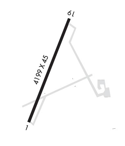
| Lat: N 3539.0 Long: W 11208.9 Elev: 5999 Var: -13 Longest Runway: 4199 | ||
| CTAF: 122.8 | ||
| ||||||
|
| Rwy | Rwy | |||||||
| 4199x45 | 4199' | 4199x45 | 4199' | |||||
| Runway ID | Single Wheel | Double Wheel | Double Tandem Wheel | Dual Double Wheel |
| 01/19 | N/A | N/A | N/A | N/A |
| These numbers are Advisory and are not limits. The Airport Manager should have more accurate Weight Limits | ||||
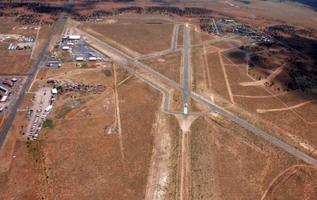
 Airport Diagram might not be current. | |
| Facility Name: | VALLE |
| City Name: | GRAND CANYON |
| County: | COCONINO |
| State abbrev: | AZ |
| State Name: | ARIZONA |
| Ownership: | PRIVATELY OWNED |
| Use: | OPEN TO THE PUBLIC |
| Owner's Name: | GRAND CANYON VALLE CORP |
| Address: | 555 S. STATE RT. 64 |
| VALLE, AZ 86046 | |
| Owner's Phone: | 928-635-5280; FAX # 928-635-5298. |
| Manager's Name: | NORM GOBEIL |
| Address: | 555 S. STATE RT. 64 |
| VALLE-WILLIAMS, AZ 86046 | |
| Phone: | 928-635-5280; EMERGENCY: COCONINO SHERIFFS DISPATCH: 928-635-4487. |
| FAA Region: | WESTERN-PACIFIC |
| FAA Field Office: | PHX |
| Date | Sunrise | Sunset |
|---|---|---|
| 09/24/21 Friday | 6:18 | 18:23 |
| 09/25/21 Saturday | 6:19 | 18:21 |
| 09/26/21 Sunday | 6:19 | 18:20 |
| 09/27/21 Monday | 6:20 | 18:18 |
| 09/28/21 Tuesday | 6:21 | 18:17 |
| 09/29/21 Wednesday | 6:22 | 18:15 |
| 09/30/21 Thursday | 6:23 | 18:14 |
| 10/01/21 Friday | 6:23 | 18:13 |
| 10/02/21 Saturday | 6:24 | 18:11 |
| 10/03/21 Sunday | 6:25 | 18:10 |
| 10/04/21 Monday | 6:26 | 18:08 |
| 10/05/21 Tuesday | 6:27 | 18:07 |
| 10/06/21 Wednesday | 6:27 | 18:05 |
| 10/07/21 Thursday | 6:28 | 18:04 |
| Airport Attendance Schedule | MON-FRI 0730-1600, SAT-SUN CLOSED |
| Airport Status | OPERATIONAL (This Status can change at any time - please check NOTAMS) |
| Airport Lighting Schedule | |
| Airport Storage Available | Tie Downs |
| Extra Services Available | NONE |
| Wind Indicator | YES - (unlit) |
| Control Tower | NO |
| CTAF Frequency | 122.800 |
| Unicom Frequency | 122.800 |
| Rotating Beacon Color | CLEAR-GREEN (Light Land Airport) |
| Segmented Circle | YES |
| Landing Fee | NO |
| Airport Inspected | STATE - performed by PRIVATE CONTRACT PERSONNEL |
| Inspection Date | 04/23/2019 |
| Type of Fuel Available | None |
| Airframe Repair Service | None |
| Power Plant Repair Service | None |
| Latitude | N3539.0 |
| Longitude | W11208.9 (ESTIMATED) |
| Arpt Elevation | 5999ft (SURVEYED) |
| Magnetic Variation | 13E |
| 25 miles S | of GRAND CANYON |
| Traffic Pattern Altitude | |
| Sectional Chart | PHOENIX |
| Operations (Reported) | Yearly | Avg. Daily |
|---|---|---|
| General Aviation Transient | 1000 | 3 |
| General Aviation Local | 200 | 1 |
| Air Taxi | 0 | 0 |
| Commerical | 0 | 0 |
| Commuter | 0 | 0 |
| Military | 250 | 1 |
| Aircraft based on Field | |
|---|---|
| General Aviation Singles | 5 |
| General Aviation Multi | 1 |
| Jet Aircraft | 0 |
| General Aviation Helicopters | 1 |
| Military Aircraft | 0 |
| Gliders | 0 |
| Ultralights | 0 |
| FSS on field | NO |
| FSS tie-in | PRESCOTT |
| FSS Phone | 1-800-WX-BRIEF |
| Who issues Notams | PRC |
| Notam D service at airport | YES |
| ARTCC Name | LOS ANGELES |
| Airport Certification | |
| Aircraft Rescue & Firefighting Index | None |
| Airport of Entry | No |
| Custom Landing Rights | No |
| Joint Civil/Military | No |
| Military Landing rights | No |
| WILDLIFE ON AND INVOF ARPT. |
| FOR CD CTC LOS ANGELES ARTCC AT 661-575-2079. |
| BIRDS OF PREY FREE FLIGHT DEMONSTRATIONS 850 TO 1000 FT EAST OF RWY 19 THLD. |
| ARPT NOT PLOWED IN WINTER, CALL AHEAD FOR RWY CONDITIONS. |
| SIGNIFICANT HELICOPTER TRNG ACTIVITY, MONITOR 122.8 WITHIN 5 NM OF ARPT. |
| ARPT CLSD ON CHRISTMAS, EASTER, NEW YEARS AND THANKSGIVING HOLIDAYS. |
Airport Communications & Frequencies:
| |||||||||
| Runway: 01 | Runway: 19 | ||
| Mag heading: | 8° | Mag heading: | 188° |
| Rwy Slope: | -.24% Down | Rwy Slope: | .24% Up |
| Approach: | Approach: | ||
| Pattern: | Left Traffic | Pattern: | Left Traffic |
| Markings: | NONPRECISION INSTRUMENT | Markings: | NONPRECISION INSTRUMENT |
| Marking Condition: | FAIR | Marking Condition: | GOOD |
| Arresting Dev: | Arresting Dev: | ||
| Lat & Long: | N3538.7 W11209.0 | Lat. & Long.: | N3539.4 W11208.7 |
| Elev: | 5998.5 ft. MSL | Elev: | 5988.6 ft. MSL |
| TCH: | TCH: | ||
| Visual Glide Path: | Visual Glide Path: | ||
| Displaced Threshold: | No | Displaced Threshold: | No |
| Touchdown Zone: | YES | Touchdown Zone: | YES |
| Touchdown Elev.: | 5998.5 feet | Touchdown Elev.: | 5996.0 feet |
| Visual Glide Slope: | Visual Glide Slope: | ||
| RVR Equipment: | RVR Equipment: | ||
| RVV Equipment: | NO | RVV Equipment: | NO |
| Approach Lights: | Approach Lights: | ||
| REIL: | NO | REIL: | NO |
| Centerline Lights: | NO | Centerline Lights: | NO |
| Touchdown lights: | NO | Touchdown lights: | NO |
| Runway Category: | Runway with a Non-precision Approach | Runway Category: | Runway with a Non-precision Approach |
| Declared Distances: | Declared Distances: | ||
| Comments: | 10 FT ROADWAY 0 FT, 200 FT FM THLD ACROSS APPROACH AREA, 250 FT EACH SIDE. 3 TO 6 FT BRUSH 0 FT, 200 FT FM THLD 90 FT, 250 FT LEFT OF CENTERLINE. | Comments: | 2 TO 3 FT SCATTERED BRUSH 0 FT, 200 FT FM THLD, 75 FT, 250 FT RIGHT OF CENTERLINE. 2 TO 3 FT SCATTERED BRUSH 10 FT, 200 FT FM CENTERLINE, 80 FT, 225 FT LEFT OF CENTERLINE. |
Thanks for using FltPlan.com
all rights reserved © 1999-2021 by Flight Plan LLC