
| DEFUNIAK SPRINGS DEFUNIAK SPRINGS FL |
| |
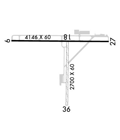
| Lat: N 3043.9 Long: W 08609.2 Elev: 289 Var: +04 Longest Runway: 4146 | ||
| AWOS: 118.72 CTAF: 123.05 | ||
| ||||||||||||||||||||||||||||||||||||||||||||
| ||||||||||||||||||||||||||||||||||||||||||||
| ||||||||||||||||||||||||||||||||||||||||||||
| Rwy | Rwy | |||||||
| 4146x60 | 4146' | 4146x60 | 3541' | |||||
| 2700x60 | 2535' | 2700x60 | 2300' | |||||
| Runway ID | Single Wheel | Double Wheel | Double Tandem Wheel | Dual Double Wheel |
| 09/27 | 20,000 | N/A | N/A | N/A |
| 18/36 | N/A | N/A | N/A | N/A |
| These numbers are Advisory and are not limits. The Airport Manager should have more accurate Weight Limits | ||||
 Airport Diagram might not be current. | |
| Facility Name: | DEFUNIAK SPRINGS |
| City Name: | DEFUNIAK SPRINGS |
| County: | WALTON |
| State abbrev: | FL |
| State Name: | FLORIDA |
| Ownership: | PUBLICLY OWNED |
| Use: | OPEN TO THE PUBLIC |
| Owner's Name: | CITY OF DE FUNIAK SPRINGS; CTC PERSON MICHAEL BARKER 850-892-8500 FAX: 850-892-6575. |
| Address: | P.O. BOX 685 |
| DEFUNIAK SPRINGS, FL 32435-0685 | |
| Owner's Phone: | 850-892-8500 |
| Manager's Name: | ANDRE LEWIS-KENT |
| Address: | 1931 US HIGHWAY 90 W |
| DE FUNIAK SPRINGS, FL 32435 | |
| Phone: | 850-892-2000 |
| FAA Region: | SOUTHERN |
| FAA Field Office: | ORL |
| Date | Sunrise | Sunset |
|---|---|---|
| 02/06/25 Thursday | 6:33 | 17:25 |
| 02/07/25 Friday | 6:32 | 17:26 |
| 02/08/25 Saturday | 6:31 | 17:27 |
| 02/09/25 Sunday | 6:31 | 17:28 |
| 02/10/25 Monday | 6:30 | 17:28 |
| 02/11/25 Tuesday | 6:29 | 17:29 |
| 02/12/25 Wednesday | 6:28 | 17:30 |
| 02/13/25 Thursday | 6:27 | 17:31 |
| 02/14/25 Friday | 6:26 | 17:32 |
| 02/15/25 Saturday | 6:26 | 17:32 |
| 02/16/25 Sunday | 6:25 | 17:33 |
| 02/17/25 Monday | 6:24 | 17:34 |
| 02/18/25 Tuesday | 6:23 | 17:35 |
| 02/19/25 Wednesday | 6:22 | 17:36 |
| Airport Attendance Schedule | MON-FRI 0800-1700 |
| Airport Status | OPERATIONAL (This Status can change at any time - please check NOTAMS) |
| Airport Lighting Schedule | ACTVT PAPI RWY 9 & 27; MIRL RWY 09/27 - CTAF. |
| Airport Storage Available | Tie Downs |
| Extra Services Available | Avionics, Flight Instruction |
| Wind Indicator | YES - (lighted) |
| Control Tower | NO |
| CTAF Frequency | 123.050 |
| Unicom Frequency | 123.050 |
| Rotating Beacon Color | WG |
| Segmented Circle | YES |
| Landing Fee | NO |
| Airport Inspected | STATE - performed by STATE AERONAUTICAL PERSONNEL |
| Inspection Date | 03/07/2024 |
| Type of Fuel Available | Grade 100LL, JET A; -10FUEL 24 HR CREDIT CARD SVC AVBL. |
| Airframe Repair Service | MAJOR |
| Power Plant Repair Service | MAJOR |
| Latitude | N3043.9 |
| Longitude | W08609.2 (ESTIMATED) |
| Arpt Elevation | 289ft (SURVEYED) |
| Magnetic Variation | 04W |
| 2 miles W | of DEFUNIAK SPRINGS |
| Traffic Pattern Altitude | |
| Sectional Chart | NEW ORLEANS |
| Operations (Reported) | Yearly | Avg. Daily |
|---|---|---|
| General Aviation Transient | 0 | 0 |
| General Aviation Local | 0 | 0 |
| Air Taxi | 0 | 0 |
| Commerical | 0 | 0 |
| Commuter | 0 | 0 |
| Military | 0 | 0 |
| Aircraft based on Field | |
|---|---|
| General Aviation Singles | 0 |
| General Aviation Multi | 0 |
| Jet Aircraft | 0 |
| General Aviation Helicopters | 0 |
| Military Aircraft | 0 |
| Gliders | 0 |
| Ultralights | 0 |
| FSS on field | NO |
| FSS tie-in | GAINESVILLE |
| FSS Phone | 1-800-WX-BRIEF |
| Who issues Notams | GNV |
| Notam D service at airport | YES |
| ARTCC Name | JACKSONVILLE |
| Airport Certification | |
| Aircraft Rescue & Firefighting Index | None |
| Airport of Entry | No |
| Custom Landing Rights | No |
| Joint Civil/Military | No |
| Military Landing rights | YES |
| NATIONAL PLAN OF INTEGRATED AIRPORT SYSTEMS (NPIAS) |
| GRANT AGREEMENTS UNDER FAAP/ADAP/AIP |
| ASSURANCES PURSUANT TO TITLE VI, CIVIL RIGHTS ACT OF 1964 |
| TREES OBST LN OF SIGHT BTN RWY 09 & 36 AND RWY 27 & 36. RWY 09 & 27 LN OF SIGHT OBST DUE TO RWY 09 UP SLOPE. |
| RWY SAFETY AREA E OF RWY 18/36. |
| RWY 09 UNLGTD FENCE & RD 160 FT S OF CNTRLN PENETRATES APCH SFC. |
Airport Communications & Frequencies:
| |||||||||||||||||
| Runway: 09 | Runway: 27 | ||
| Mag heading: | 94° | Mag heading: | 274° |
| Rwy Slope: | -.14% Down | Rwy Slope: | .14% Up |
| Approach: | Approach: | ||
| Pattern: | Left Traffic | Pattern: | Left Traffic |
| Markings: | NONPRECISION INSTRUMENT | Markings: | NONPRECISION INSTRUMENT |
| Marking Condition: | GOOD | Marking Condition: | GOOD |
| Arresting Dev: | Arresting Dev: | ||
| Lat & Long: | N3044.0 W08609.6 | Lat. & Long.: | N3044.0 W08608.9 |
| Elev: | 283.6 ft. MSL | Elev: | 278.0 ft. MSL |
| TCH: | 43 ft. AGL | TCH: | 49 ft. AGL |
| Visual Glide Path: | 3.00 degrees | Visual Glide Path: | 3.00 degrees |
| Displaced Threshold: | No | Displaced Threshold: | 605 feet |
| Touchdown Zone: | YES | Touchdown Zone: | YES |
| Touchdown Elev.: | 289.1 feet | Touchdown Elev.: | 288.0 feet |
| Visual Glide Slope: | 2-Light PAPI on LEFT side of Runway | Visual Glide Slope: | 2-Light PAPI on LEFT side of Runway |
| RVR Equipment: | RVR Equipment: | ||
| RVV Equipment: | NO | RVV Equipment: | NO |
| Approach Lights: | Approach Lights: | ||
| REIL: | NO | REIL: | NO |
| Centerline Lights: | NO | Centerline Lights: | NO |
| Touchdown lights: | NO | Touchdown lights: | NO |
| Runway Category: | Runway with a Non-precision Approach | Runway Category: | Runway with a Non-precision Approach |
| Declared Distances: | Declared Distances: | ||
| Obstructions: | FENCE | Obstructions: | RR |
| Marked: | NOT Marked/Lighted | Marked: | NOT Marked/Lighted |
| Clearance slope: | Clearance slope: | 9:1; RWY 27 APCH SLOPE 25:1 TO DTHR. | |
| Obstruction height: | 6 feet AGL | Obstruction height: | 28 feet AGL |
| Dist. from runway: | 200 feet | Dist. from runway: | 475 feet |
| Centerline offset: | 165 right of centerline | Centerline offset: | 250 feet right of centerline |
| Comments: | FENCE 6FT TALL, 200 FT BFR AER, 160 FT RIGHT OF CNTRLN. | Comments: |
| Runway: 18 | Runway: 36 | ||
| Mag heading: | 185° | Mag heading: | 5° |
| Rwy Slope: | -.50% Down | Rwy Slope: | .50% Up |
| Approach: | Approach: | ||
| Pattern: | Left Traffic | Pattern: | Left Traffic |
| Markings: | NONSTANDARD | Markings: | NONSTANDARD |
| Marking Condition: | FAIR; WHITE PVC PIPE EVERY 200 FT. | Marking Condition: | FAIR; WHITE PVC PIPE EVERY 200 FT. |
| Arresting Dev: | Arresting Dev: | ||
| Lat & Long: | N3044.0 W08609.2 | Lat. & Long.: | N3043.5 W08609.2 |
| Elev: | 282.1 ft. MSL | Elev: | 268.7 ft. MSL |
| TCH: | TCH: | ||
| Visual Glide Path: | Visual Glide Path: | ||
| Displaced Threshold: | 165 feet | Displaced Threshold: | 400 feet |
| Touchdown Zone: | NO | Touchdown Zone: | NO |
| Touchdown Elev.: | Touchdown Elev.: | ||
| Visual Glide Slope: | Visual Glide Slope: | ||
| RVR Equipment: | RVR Equipment: | ||
| RVV Equipment: | NO | RVV Equipment: | NO |
| Approach Lights: | Approach Lights: | ||
| REIL: | NO | REIL: | NO |
| Centerline Lights: | NO | Centerline Lights: | NO |
| Touchdown lights: | NO | Touchdown lights: | NO |
| Runway Category: | Runway with a Visual Approach | Runway Category: | Runway with a Visual Approach |
| Declared Distances: | Declared Distances: | ||
| Obstructions: | PLINE | Obstructions: | TREES |
| Marked: | NOT Marked/Lighted | Marked: | NOT Marked/Lighted |
| Clearance slope: | 28:1 | Clearance slope: | 50:1 |
| Obstruction height: | 34 feet AGL | Obstruction height: | 26 feet AGL |
| Dist. from runway: | 933 feet | Dist. from runway: | 1280 feet |
| Centerline offset: | 75 left of centerline | Centerline offset: | 105 feet right of centerline |
| Comments: | Comments: |
Thanks for using FltPlan.com
all rights reserved © 1999-2025 by Flight Plan LLC
