
| MAVERICK COUNTY MEMORIAL INTL EAGLE PASS TX |
| |
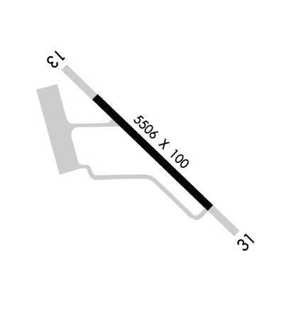
| Lat: N 2851.4 Long: W 10030.8 Elev: 887 Var: -06 Longest Runway: 5506 | ||
| AWOS: 119.17 CTAF: 122.8 | ||
| ||||||
| ||||||
|
| Rwy | Rwy | |||||||
| 5506x100 | 5506' | 5506x100 | 5506' | |||||
| Runway ID | Single Wheel | Double Wheel | Double Tandem Wheel | Dual Double Wheel |
| 13/31 | N/A | N/A | N/A | N/A |
| These numbers are Advisory and are not limits. The Airport Manager should have more accurate Weight Limits | ||||
 Airport Diagram might not be current. | |
| Facility Name: | MAVERICK COUNTY MEML INTL |
| City Name: | EAGLE PASS |
| County: | MAVERICK |
| State abbrev: | TX |
| State Name: | TEXAS |
| Ownership: | PUBLICLY OWNED |
| Use: | OPEN TO THE PUBLIC |
| Owner's Name: | COUNTY OF MAVERICK |
| Address: | 500 QUARRY |
| EAGLE PASS, TX 78852 | |
| Owner's Phone: | 830-773-3824 |
| Manager's Name: | LESLIE BEATTIE; COUNTY JUDGE- DAVID SAUCEDO 830-773-3824. |
| Address: | 500 QUARRY STREET, SUITE 3 |
| EAGLE PASS, TX 78852 | |
| Phone: | 830-773-9636; AIRPORT OFFICE TELEPHONE 830-773-9636. |
| FAA Region: | SOUTHWEST |
| FAA Field Office: | TEX |
| Date | Sunrise | Sunset |
|---|---|---|
| 09/24/21 Friday | 7:31 | 19:36 |
| 09/25/21 Saturday | 7:32 | 19:35 |
| 09/26/21 Sunday | 7:32 | 19:34 |
| 09/27/21 Monday | 7:33 | 19:33 |
| 09/28/21 Tuesday | 7:33 | 19:32 |
| 09/29/21 Wednesday | 7:34 | 19:30 |
| 09/30/21 Thursday | 7:34 | 19:29 |
| 10/01/21 Friday | 7:35 | 19:28 |
| 10/02/21 Saturday | 7:36 | 19:27 |
| 10/03/21 Sunday | 7:36 | 19:26 |
| 10/04/21 Monday | 7:37 | 19:25 |
| 10/05/21 Tuesday | 7:37 | 19:23 |
| 10/06/21 Wednesday | 7:38 | 19:22 |
| 10/07/21 Thursday | 7:38 | 19:21 |
| Airport Attendance Schedule | MON-FRI 0830-1800, SAT-SUN 1000-1600 |
| Airport Status | OPERATIONAL (This Status can change at any time - please check NOTAMS) |
| Airport Lighting Schedule | DUSK-DAWN. MIRL RY 13/31 PRESET LOW INTST; TO INCR INTST ACTVT - CTAF. |
| Airport Storage Available | Tie Downs |
| Extra Services Available | NONE |
| Wind Indicator | YES - (lighted) |
| Control Tower | NO |
| CTAF Frequency | 122.800 |
| Unicom Frequency | 122.800 |
| Rotating Beacon Color | |
| Segmented Circle | YES |
| Landing Fee |
| Airport Inspected | No Inspection Data Available performed by STATE AERONAUTICAL PERSONNEL |
| Inspection Date | 08/25/2016 |
| Type of Fuel Available | Grade 100LL, JET A (freeze point -40C) |
| Airframe Repair Service | NONE |
| Power Plant Repair Service | NONE |
| Latitude | N2851.4 |
| Longitude | W10030.8 (ESTIMATED) |
| Arpt Elevation | 887ft (ESTIMATED) |
| Magnetic Variation | 06E |
| 8 miles N | of EAGLE PASS |
| Traffic Pattern Altitude | |
| Sectional Chart | SAN ANTONIO |
| Operations (Reported) | Yearly | Avg. Daily |
|---|---|---|
| General Aviation Transient | 1100 | 3 |
| General Aviation Local | 12 | 0 |
| Air Taxi | 0 | 0 |
| Commerical | 0 | 0 |
| Commuter | 0 | 0 |
| Military | 0 | 0 |
| Aircraft based on Field | |
|---|---|
| General Aviation Singles | 0 |
| General Aviation Multi | 0 |
| Jet Aircraft | 0 |
| General Aviation Helicopters | 0 |
| Military Aircraft | 0 |
| Gliders | 0 |
| Ultralights | 0 |
| FSS on field | NO |
| FSS tie-in | SAN ANGELO |
| FSS Phone | 1-800-WX-BRIEF |
| Who issues Notams | SJT |
| Notam D service at airport | YES |
| ARTCC Name | HOUSTON |
| Airport Certification | |
| Aircraft Rescue & Firefighting Index | None |
| Airport of Entry | YES |
| Custom Landing Rights | YES |
| Joint Civil/Military | No |
| Military Landing rights | YES |
| NATIONAL PLAN OF INTEGRATED AIRPORT SYSTEMS (NPIAS) |
| SURPLUS PROPERTY AGREEMENT UNDER PUBLIC LAW 289 |
| FLIGHT NOTIFICATION SERVICE (ADCUS) AVBL. |
| FOR CD IF UNA TO CTC ON FSS FREQ, CTC HOUSTON ARTCC AT 281-230-5622. |
| RWY 13/3 1 RWY HAS CRACKS WITH VEGETATION. |
Airport Communications & Frequencies:
| |||||||||||||||||
| Runway: 13 | Runway: 31 | ||
| Mag heading: | N/A | Mag heading: | N/A |
| Rwy Slope: | -.09% Down | Rwy Slope: | .09% Up |
| Approach: | Approach: | ||
| Pattern: | Left Traffic | Pattern: | Left Traffic |
| Markings: | NONPRECISION INSTRUMENT | Markings: | NONPRECISION INSTRUMENT |
| Marking Condition: | POOR; RY MARKINGS FADED. | Marking Condition: | POOR; RY MARKINGS FADED. |
| Arresting Dev: | Arresting Dev: | ||
| Lat & Long: | N2851.7 W10031.2 | Lat. & Long.: | N2851.1 W10030.4 |
| Elev: | 887.2 ft. MSL | Elev: | 882.2 ft. MSL |
| TCH: | TCH: | ||
| Visual Glide Path: | Visual Glide Path: | ||
| Displaced Threshold: | No | Displaced Threshold: | No |
| Touchdown Zone: | YES | Touchdown Zone: | YES |
| Touchdown Elev.: | 887.2 feet | Touchdown Elev.: | 882.3 feet |
| Visual Glide Slope: | Visual Glide Slope: | ||
| RVR Equipment: | RVR Equipment: | ||
| RVV Equipment: | NO | RVV Equipment: | NO |
| Approach Lights: | Approach Lights: | ||
| REIL: | NO | REIL: | NO |
| Centerline Lights: | NO | Centerline Lights: | NO |
| Touchdown lights: | NO | Touchdown lights: | NO |
| Runway Category: | Runway with a Non-precision Approach having visibility minimums greater than 3/4 mile | Runway Category: | Runway with a Non-precision Approach having visibility minimums greater than 3/4 mile |
| Declared Distances: | Declared Distances: | ||
| Obstructions: | BRUSH | Obstructions: | BRUSH |
| Marked: | NOT Marked/Lighted | Marked: | NOT Marked/Lighted |
| Clearance slope: | Clearance slope: | ||
| Obstruction height: | 25 feet AGL | Obstruction height: | 8 feet AGL |
| Dist. from runway: | 200 feet | Dist. from runway: | 200 feet |
| Centerline offset: | 160 left of centerline | Centerline offset: | 203 feet right of centerline |
| Comments: | 5-10 FT BRUSH 0-200 FT FM THLD 175-250 FT LEFT AND RIGHT. | Comments: | RWY 31 +4'-8' BRUSH 0'-200' FM THR, 200 FT RIGHT AND LEFT OF CENTERLINE. |
Thanks for using FltPlan.com
all rights reserved © 1999-2021 by Flight Plan LLC
