
| LIVE OAK COUNTY GEORGE WEST TX |
| |
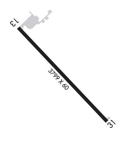
| Lat: N 2821.8 Long: W 09807.0 Elev: 129 Var: -07 Longest Runway: 3799 | ||
| CTAF: 122.9 | ||
| ||||||||||||||||||||||||||||||||||||||||||||
| ||||||||||||||||||||||||||||||||||||||||||||
| Rwy | Rwy | |||||||
| 3799x60 | 3799' | 3799x60 | 3799' | |||||
| Runway ID | Single Wheel | Double Wheel | Double Tandem Wheel | Dual Double Wheel |
| 13/31 | N/A | N/A | N/A | N/A |
| These numbers are Advisory and are not limits. The Airport Manager should have more accurate Weight Limits | ||||
 Airport Diagram might not be current. | |
| Facility Name: | LIVE OAK COUNTY |
| City Name: | GEORGE WEST |
| County: | LIVE OAK |
| State abbrev: | TX |
| State Name: | TEXAS |
| Ownership: | PUBLICLY OWNED |
| Use: | OPEN TO THE PUBLIC |
| Owner's Name: | LIVE OAK COUNTY |
| Address: | COUNTY COURTHOUSE |
| GEORGE WEST, TX 78022 | |
| Owner's Phone: | 361-449-2733 |
| Manager's Name: | JAMES LISKA; COUNTY JUDGE |
| Address: | PO BOX 487 |
| GEORGE WEST, TX 78022 | |
| Phone: | 361-449-8002 |
| FAA Region: | SOUTHWEST |
| FAA Field Office: | TEX |

| Date | Sunrise | Sunset |
|---|---|---|
| 02/11/25 Tuesday | 7:14 | 18:20 |
| 02/12/25 Wednesday | 7:13 | 18:21 |
| 02/13/25 Thursday | 7:12 | 18:22 |
| 02/14/25 Friday | 7:12 | 18:22 |
| 02/15/25 Saturday | 7:11 | 18:23 |
| 02/16/25 Sunday | 7:10 | 18:24 |
| 02/17/25 Monday | 7:09 | 18:24 |
| 02/18/25 Tuesday | 7:08 | 18:25 |
| 02/19/25 Wednesday | 7:07 | 18:26 |
| 02/20/25 Thursday | 7:06 | 18:27 |
| 02/21/25 Friday | 7:05 | 18:27 |
| 02/22/25 Saturday | 7:04 | 18:28 |
| 02/23/25 Sunday | 7:04 | 18:29 |
| 02/24/25 Monday | 7:03 | 18:29 |
| Airport Attendance Schedule | UNATTENDED |
| Airport Status | OPERATIONAL (This Status can change at any time - please check NOTAMS) |
| Airport Lighting Schedule | DUSK-DAWN. MIRL RWY 13/31 PRESET LOW INTST; TO INCR INTST ACTVT - 122.7. |
| Airport Storage Available | Tie Downs |
| Extra Services Available | NONE |
| Wind Indicator | YES - (lighted) |
| Control Tower | NO |
| CTAF Frequency | 122.900 |
| Unicom Frequency | |
| Rotating Beacon Color | WG |
| Segmented Circle | YES |
| Landing Fee |
| Airport Inspected | STATE - performed by PRIVATE CONTRACT PERSONNEL |
| Inspection Date | 05/26/2023 |
| Type of Fuel Available | Grade 100LL, JET A (freeze point -40C); -10FUEL SELF-SERVE. |
| Airframe Repair Service | None |
| Power Plant Repair Service | None |
| Latitude | N2821.8 |
| Longitude | W09807.0 (ESTIMATED) |
| Arpt Elevation | 128ft (SURVEYED) |
| Magnetic Variation | 07E |
| 2 miles N | of GEORGE WEST |
| Traffic Pattern Altitude | |
| Sectional Chart | SAN ANTONIO |
| Operations (Reported) | Yearly | Avg. Daily |
|---|---|---|
| General Aviation Transient | 0 | 0 |
| General Aviation Local | 0 | 0 |
| Air Taxi | 0 | 0 |
| Commerical | 0 | 0 |
| Commuter | 0 | 0 |
| Military | 0 | 0 |
| Aircraft based on Field | |
|---|---|
| General Aviation Singles | 0 |
| General Aviation Multi | 0 |
| Jet Aircraft | 0 |
| General Aviation Helicopters | 0 |
| Military Aircraft | 0 |
| Gliders | 0 |
| Ultralights | 0 |
| FSS on field | NO |
| FSS tie-in | SAN ANGELO |
| FSS Phone | 1-800-WX-BRIEF |
| Who issues Notams | SJT |
| Notam D service at airport | YES |
| ARTCC Name | HOUSTON |
| Airport Certification | |
| Aircraft Rescue & Firefighting Index | None |
| Airport of Entry | No |
| Custom Landing Rights | No |
| Joint Civil/Military | No |
| Military Landing rights | No |
| BIRDS ON & INVOF ARPT. |
| FOR CD CTC HOUSTON ARTCC AT 281-230-5622. |
| 75 FT ELEC TRANSMISSION LINE, 600 FT W OF AND PARL TO RWY CNTRLN, FULL LEN. |
| FOR ASSISTANCE OR HNGR CALL 361-449-2559 OR 361-449-6315 (CELL). |
| (CONTACT PHONE NR) LTDAVIS@LIVE.COM ALT 361-449-2093 |
Airport Communications & Frequencies:
| |||||||
| Runway: 13 | Runway: 31 | ||
| Mag heading: | 129° | Mag heading: | 309° |
| Rwy Slope: | -.08% Down | Rwy Slope: | .08% Up |
| Approach: | Approach: | ||
| Pattern: | Left Traffic | Pattern: | Left Traffic |
| Markings: | NONPRECISION INSTRUMENT | Markings: | NONPRECISION INSTRUMENT |
| Marking Condition: | GOOD | Marking Condition: | GOOD |
| Arresting Dev: | Arresting Dev: | ||
| Lat & Long: | N2822.0 W09807.2 | Lat. & Long.: | N2821.5 W09806.7 |
| Elev: | 128.4 ft. MSL | Elev: | 125.4 ft. MSL |
| TCH: | 53 ft. AGL | TCH: | 45 ft. AGL |
| Visual Glide Path: | 3.00 degrees | Visual Glide Path: | 3.00 degrees |
| Displaced Threshold: | No | Displaced Threshold: | No |
| Touchdown Zone: | YES | Touchdown Zone: | YES |
| Touchdown Elev.: | 128.7 feet | Touchdown Elev.: | 128.6 feet |
| Visual Glide Slope: | 2-Light PAPI on LEFT side of Runway | Visual Glide Slope: | 2-Light PAPI on LEFT side of Runway |
| RVR Equipment: | RVR Equipment: | ||
| RVV Equipment: | NO | RVV Equipment: | NO |
| Approach Lights: | Approach Lights: | ||
| REIL: | NO | REIL: | NO |
| Centerline Lights: | NO | Centerline Lights: | NO |
| Touchdown lights: | NO | Touchdown lights: | NO |
| Runway Category: | Runway with a Non-precision Approach | Runway Category: | Runway with a Visual Approach |
| Declared Distances: | Declared Distances: | ||
| Obstructions: | PLINE | Obstructions: | |
| Marked: | NOT Marked/Lighted | Marked: | |
| Clearance slope: | 23:1 | Clearance slope: | 50:1 |
| Obstruction height: | 50 feet AGL | Obstruction height: | |
| Dist. from runway: | 1361 feet | Dist. from runway: | |
| Centerline offset: | 264 right of centerline | Centerline offset: | |
| Comments: | Comments: |
Thanks for using FltPlan.com
all rights reserved © 1999-2025 by Flight Plan LLC