| FORT WORTH ALLIANCE FORT WORTH TX |
| |
| Lat: N 3259.4 Long: W 09719.2 Elev: 723 Var: -04 Longest Runway: 11125 | ||
| Clr Del: 128.72 Dept. ATIS: 126.92 Arr. ATIS: 126.92 AWOS: 126.92 Ground: 132.65 Tower: 135.15 | ||
| |||||||||||||||||||||||||||||||||||||||||||||||||||||||||||||||||||||
| |||||||||||||||||||||||||||||||||||||||||||||||||||||||||||||||||||||
| |||||||||||||||||||||||||||||||||||||||||||||||||||||||||||||||||||||
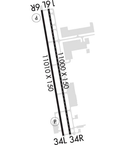
| Rwy | Rwy | |||||||
| 11000x150 | 11000' | 110.15 - 166° | 11000x150 | 11000' | 110.15 - 346° | |||
| 11125x150 | 11125' | 11125x150 | 10409' | |||||
| Runway ID | Single Wheel | Double Wheel | Double Tandem Wheel | Dual Double Wheel |
| 16L/34R | N/A | 200,000 | 400,000 | 870,000 |
| 16R/34L | N/A | 200,000 | 400,000 | 870,000 |
| These numbers are Advisory and are not limits. The Airport Manager should have more accurate Weight Limits | ||||
 Airport Diagram might not be current. | |
| Facility Name: | PEROT FLD/FORT WORTH ALLIANCE |
| City Name: | FORT WORTH |
| County: | TARRANT |
| State abbrev: | TX |
| State Name: | TEXAS |
| Ownership: | PUBLICLY OWNED |
| Use: | OPEN TO THE PUBLIC |
| Owner's Name: | CITY OF FORT WORTH |
| Address: | 1000 THROCKMORTON |
| FORT WORTH, TX 76177 | |
| Owner's Phone: | 817-392-6116 |
| Manager's Name: | CHRISTIAN CHILDS |
| Address: | 2221 ALLIANCE BLVD SUITE 100 |
| FORT WORTH, TX 76177 | |
| Phone: | 817-890-1000 |
| FAA Region: | SOUTHWEST |
| FAA Field Office: | TEX |
| Date | Sunrise | Sunset |
|---|---|---|
| 04/15/25 Tuesday | 7:00 | 20:00 |
| 04/16/25 Wednesday | 6:59 | 20:00 |
| 04/17/25 Thursday | 6:57 | 20:01 |
| 04/18/25 Friday | 6:56 | 20:02 |
| 04/19/25 Saturday | 6:55 | 20:02 |
| 04/20/25 Sunday | 6:54 | 20:03 |
| 04/21/25 Monday | 6:53 | 20:04 |
| 04/22/25 Tuesday | 6:52 | 20:05 |
| 04/23/25 Wednesday | 6:50 | 20:05 |
| 04/24/25 Thursday | 6:49 | 20:06 |
| 04/25/25 Friday | 6:48 | 20:07 |
| 04/26/25 Saturday | 6:47 | 20:08 |
| 04/27/25 Sunday | 6:46 | 20:08 |
| 04/28/25 Monday | 6:45 | 20:09 |
| Airport Attendance Schedule | CONTINUOUS |
| Airport Status | OPERATIONAL (This Status can change at any time - please check NOTAMS) |
| Airport Lighting Schedule | SS-SR |
| Airport Storage Available | Tie Downs, Hanger |
| Extra Services Available | Avionics, Cargo Handling |
| Wind Indicator | YES - (lighted) |
| Control Tower | YES |
| CTAF Frequency | |
| Unicom Frequency | ARINC FREQ 129.75 AVBL. |
| Rotating Beacon Color | WG |
| Segmented Circle | YES |
| Landing Fee |
| Airport Inspected | FEDERAL - performed by FAA AIRPORTS FIELD PERSONNEL |
| Inspection Date | 04/16/2024 |
| Type of Fuel Available | Grade 100LL, JET A-1 (icing inhibitor, freeze point -50C) |
| Airframe Repair Service | MAJOR; PRIOR ARRANGEMENTS REQUIRED FOR AIRFRAME OR POWER PLANT REPAIRS FOR DESIGN GROUP III & ABOVE. |
| Power Plant Repair Service | MAJOR |
| Latitude | N3259.4 |
| Longitude | W09719.2 (ESTIMATED) |
| Arpt Elevation | 723ft (SURVEYED) |
| Magnetic Variation | 04E |
| 14 miles N | of FORT WORTH |
| Traffic Pattern Altitude | |
| Sectional Chart | DALLAS-FT WORTH |
| Operations (Reported) | Yearly | Avg. Daily |
|---|---|---|
| General Aviation Transient | 0 | 0 |
| General Aviation Local | 0 | 0 |
| Air Taxi | 0 | 0 |
| Commerical | 0 | 0 |
| Commuter | 0 | 0 |
| Military | 0 | 0 |
| Aircraft based on Field | |
|---|---|
| General Aviation Singles | 0 |
| General Aviation Multi | 0 |
| Jet Aircraft | 0 |
| General Aviation Helicopters | 0 |
| Military Aircraft | 0 |
| Gliders | 0 |
| Ultralights | 0 |
| FSS on field | NO |
| FSS tie-in | FORT WORTH |
| FSS Phone | 1-800-WX-BRIEF |
| Who issues Notams | AFW |
| Notam D service at airport | YES |
| ARTCC Name | FORT WORTH |
| Airport Certification | ARFF INDEX E AVAILABLE. PPR FOR ACR OPNS WITH MORE THAN 30 PSGR SEATS CALL 817-890-1000 OR 800-318-9268. |
| Aircraft Rescue & Firefighting Index | AIRPORT HAS A CERTIFICATE UNDER CFR PART 139 |
| Airport of Entry | No |
| Custom Landing Rights | No; US CUSTOMS USER FEE ARPT. |
| Joint Civil/Military | No |
| Military Landing rights | YES |
| NATIONAL PLAN OF INTEGRATED AIRPORT SYSTEMS (NPIAS) |
| GRANT AGREEMENTS UNDER FAAP/ADAP/AIP |
| ASSURANCES PURSUANT TO TITLE VI, CIVIL RIGHTS ACT OF 1964 |
| FLIGHT NOTIFICATION SERVICE (ADCUS) AVBL. |
| PORTIONS OF TWY H MOVEMENT AREA EAST OF TWY A IS NOT VISIBLE FROM ATCT. |
Airport Communications & Frequencies:
| |||||||||||||||||||||||||||||
| Runway: 16L | Runway: 34R | ||
| Mag heading: | 166° | Mag heading: | 346° |
| Rwy Slope: | -.54% Down | Rwy Slope: | .54% Up |
| Approach: | ILS/DME | Approach: | ILS/DME |
| Pattern: | Right Traffic | Pattern: | Left Traffic |
| Markings: | PRECISION INSTRUMENT | Markings: | PRECISION INSTRUMENT |
| Marking Condition: | GOOD | Marking Condition: | GOOD |
| Arresting Dev: | Arresting Dev: | ||
| Lat & Long: | N3300.3 W09719.3 | Lat. & Long.: | N3258.5 W09718.9 |
| Elev: | 723.1 ft. MSL | Elev: | 664.2 ft. MSL |
| TCH: | TCH: | ||
| Visual Glide Path: | Visual Glide Path: | ||
| Displaced Threshold: | No | Displaced Threshold: | No |
| Touchdown Zone: | YES | Touchdown Zone: | YES |
| Touchdown Elev.: | 723.2 feet | Touchdown Elev.: | 681.0 feet |
| Visual Glide Slope: | Visual Glide Slope: | ||
| RVR Equipment: | TOUCHDOWN-MIDFIELD-ROLLOUT | RVR Equipment: | TOUCHDOWN-MIDFIELD-ROLLOUT |
| RVV Equipment: | NO | RVV Equipment: | NO |
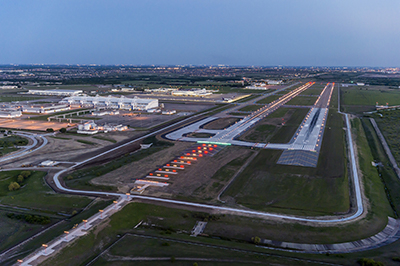
| Approach Lights: | ALSF2 - standard 2,400 foot high intensity approach lighting system with sequenced flashers, Category II or III | Approach Lights: | MALSR - 1,400 foot medium intensity approach lighting system with runway alignment indicator lights |
| REIL: | NO | REIL: | NO |
| Centerline Lights: | YES | Centerline Lights: | YES |
| Touchdown lights: | YES | Touchdown lights: | YES |
| Runway Category: | Precision Instrument Runway | Runway Category: | Precision Instrument Runway |
| Declared Distances: | TORA:10600' TODA:10600' ASDA:10600' LDA:10600' | Declared Distances: | TORA:11000' TODA:11000' ASDA:11000' LDA:11000' |
| Obstructions: | Obstructions: | PLINE | |
| Marked: | Marked: | LIGHTED | |
| Clearance slope: | 50:1 | Clearance slope: | 42:1 |
| Obstruction height: | Obstruction height: | 182 feet AGL | |
| Dist. from runway: | Dist. from runway: | 7920 feet | |
| Centerline offset: | Centerline offset: | 590 feet right of centerline | |
| Comments: | Comments: |
| Runway: 16R | Runway: 34L | ||
| Mag heading: | 166° | Mag heading: | 346° |
| Rwy Slope: | -.51% Down | Rwy Slope: | .51% Up |
| Approach: | Approach: | ||
| Pattern: | Right Traffic | Pattern: | Left Traffic |
| Markings: | PRECISION INSTRUMENT | Markings: | PRECISION INSTRUMENT |
| Marking Condition: | GOOD | Marking Condition: | GOOD |
| Arresting Dev: | Arresting Dev: | ||
| Lat & Long: | N3300.3 W09719.4 | Lat. & Long.: | N3258.5 W09719.0 |
| Elev: | 721.2 ft. MSL | Elev: | 664.7 ft. MSL |
| TCH: | 82 ft. AGL | TCH: | 74 ft. AGL |
| Visual Glide Path: | 3.00 degrees | Visual Glide Path: | 3.00 degrees |
| Displaced Threshold: | No | Displaced Threshold: | 716 feet |
| Touchdown Zone: | YES | Touchdown Zone: | YES |
| Touchdown Elev.: | 721.2 feet | Touchdown Elev.: | 686.6 feet |
| Visual Glide Slope: | 4-Light PAPI on RIGHT side of Runway | Visual Glide Slope: | 4-Light PAPI on LEFT side of Runway |
| RVR Equipment: | RVR Equipment: | ||
| RVV Equipment: | NO | RVV Equipment: | NO |
| Approach Lights: | Approach Lights: | ||
| REIL: | YES | REIL: | YES |
| Centerline Lights: | NO | Centerline Lights: | NO |
| Touchdown lights: | NO | Touchdown lights: | NO |
| Runway Category: | Runway with a Visual Approach | Runway Category: | Runway with a Visual Approach |
| Declared Distances: | TORA:11010' TODA:11010' ASDA:10410' LDA:10410' | Declared Distances: | TORA:11010' TODA:11010' ASDA:11010' LDA:10409' |
| Obstructions: | RR | Obstructions: | FENCE |
| Marked: | NOT Marked/Lighted | Marked: | NOT Marked/Lighted |
| Clearance slope: | 21:1; APCH RATIO 0:1 BASED ON DSPLCD THLD; +5 FT FENCE 0 FT, 250 FT R. | Clearance slope: | APCH RATIO 50:1 TO DSPLCD THLD. |
| Obstruction height: | 19 feet AGL | Obstruction height: | 4 feet AGL |
| Dist. from runway: | 607 feet | Dist. from runway: | 200 feet |
| Centerline offset: | 287 right of centerline | Centerline offset: | 250 feet left of centerline |
| Comments: | Comments: | +4 FT FENCE 0 FT 250 FT L; APCH RATIO 0:1 BASED ON DSPLCD THLD. |
Thanks for using FltPlan.com
all rights reserved © 1999-2025 by Flight Plan LLC