
| WATERLOO RGNL WATERLOO IA |
| |
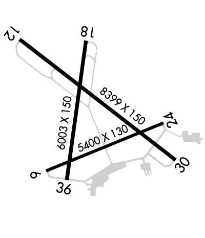
| Lat: N 4233.5 Long: W 09224.1 Elev: 873 Var: -00 Longest Runway: 8399 | ||
| Dept. ATIS: 120.65 Arr. ATIS: 120.65 AWOS: 120.65 Ground: 121.9 Tower: 125.07 | ||
| ||||||||||||||||||||||||||||||||||||||||||||
| ||||||||||||||||||||||||||||||||||||||||||||
| ||||||||||||||||||||||||||||||||||||||||||||
| Rwy | Rwy | |||||||
| 8399x150 | 8399' | 111.70 - 127° | 8399x150 | 8399' | ||||
| 6003x150 | 6003' | 6003x150 | 6003' | |||||
| Runway ID | Single Wheel | Double Wheel | Double Tandem Wheel | Dual Double Wheel |
| 12/30 | 55,000 | 75,000 | 140,000 | N/A |
| 18/36 | 50,000 | 75,000 | N/A | N/A |
| These numbers are Advisory and are not limits. The Airport Manager should have more accurate Weight Limits | ||||
 Airport Diagram might not be current. | |
| Facility Name: | WATERLOO RGNL |
| City Name: | WATERLOO |
| County: | BLACK HAWK |
| State abbrev: | IA |
| State Name: | IOWA |
| Ownership: | PUBLICLY OWNED |
| Use: | OPEN TO THE PUBLIC |
| Owner's Name: | CITY OF WATERLOO |
| Address: | 715 MULBERRY |
| WATERLOO, IA 50701 | |
| Owner's Phone: | 319-291-4323 |
| Manager's Name: | MR. STEVEN KJERGAARD |
| Address: | 2790 LIVINGSTON LANE |
| WATERLOO, IA 50703 | |
| Phone: | 319-291-4483 |
| FAA Region: | CENTRAL |
| FAA Field Office: | NONE |
| Date | Sunrise | Sunset |
|---|---|---|
| 03/14/25 Friday | 7:24 | 19:15 |
| 03/15/25 Saturday | 7:22 | 19:16 |
| 03/16/25 Sunday | 7:20 | 19:17 |
| 03/17/25 Monday | 7:19 | 19:18 |
| 03/18/25 Tuesday | 7:17 | 19:19 |
| 03/19/25 Wednesday | 7:15 | 19:21 |
| 03/20/25 Thursday | 7:13 | 19:22 |
| 03/21/25 Friday | 7:12 | 19:23 |
| 03/22/25 Saturday | 7:10 | 19:24 |
| 03/23/25 Sunday | 7:08 | 19:25 |
| 03/24/25 Monday | 7:06 | 19:26 |
| 03/25/25 Tuesday | 7:05 | 19:27 |
| 03/26/25 Wednesday | 7:03 | 19:29 |
| 03/27/25 Thursday | 7:01 | 19:30 |
| Airport Attendance Schedule | 7 Days A Week 0500-2100 |
| Airport Status | OPERATIONAL (This Status can change at any time - please check NOTAMS) |
| Airport Lighting Schedule | WHEN ATCT CLSD ACTVT MALSR RWY 12; MALS RWY 30; VASI RWY 18; PAPI RWY 36; MIRL RWYS 18/36, AND HIRL RWY 12/30 - CTAF. |
| Airport Storage Available | Tie Downs, Hanger |
| Extra Services Available | Air Ambulance, Charter, Flight Instruction, Aircraft Rental |
| Wind Indicator | YES - (lighted) |
| Control Tower | YES |
| CTAF Frequency | 125.075 |
| Unicom Frequency | 122.950 |
| Rotating Beacon Color | WG |
| Segmented Circle | NO |
| Landing Fee | NO |
| Airport Inspected | FEDERAL - performed by FAA AIRPORTS FIELD PERSONNEL |
| Inspection Date | 11/20/2024 |
| Type of Fuel Available | Grade 100LL, JET A (freeze point -40C); -10FUEL AVBL ON REQ. FEE FOR SVCS. |
| Airframe Repair Service | MAJOR |
| Power Plant Repair Service | MAJOR |
| Latitude | N4233.5 |
| Longitude | W09224.1 (ESTIMATED) |
| Arpt Elevation | 873ft (SURVEYED) |
| Magnetic Variation | 00E |
| 4 miles NW | of WATERLOO |
| Traffic Pattern Altitude | |
| Sectional Chart | CHICAGO |
| Operations (Reported) | Yearly | Avg. Daily |
|---|---|---|
| General Aviation Transient | 0 | 0 |
| General Aviation Local | 0 | 0 |
| Air Taxi | 0 | 0 |
| Commerical | 0 | 0 |
| Commuter | 0 | 0 |
| Military | 0 | 0 |
| Aircraft based on Field | |
|---|---|
| General Aviation Singles | 0 |
| General Aviation Multi | 0 |
| Jet Aircraft | 0 |
| General Aviation Helicopters | 0 |
| Military Aircraft | 0 |
| Gliders | 0 |
| Ultralights | 0 |
| FSS on field | NO |
| FSS tie-in | FORT DODGE |
| FSS Phone | 1-800-WX-BRIEF |
| Who issues Notams | ALO |
| Notam D service at airport | YES |
| ARTCC Name | CHICAGO |
| Airport Certification | AIRPORT RECEIVING SCHEDULED AIR CARRIER SERVICE FROM CARRIERS CERTIFICATED BY THE CIVIL AERONAUTICS BOARD; CLSD TO UNSKED ACR OPNS WITH MORE THAN 10 PSGR SEATS EXCP 72 HRS PPR AMGR. CALL AMGR 319-291-4483. CELL 319-529-1388 ARFF INDEX B PROVIDED. ARFF INDEX C AVBL ON 72 HRS REQ. AIR CARRIER OPS OVER 9 PSGR SEATS NOT AUTH OVER 15 MINUTES BEFORE OR AFTER SKED ARR OR DEP TIMES EXCP WITH PRIOR COORD W |
| Aircraft Rescue & Firefighting Index | AIRPORT HAS A CERTIFICATE UNDER CFR PART 139 |
| Airport of Entry | No |
| Custom Landing Rights | No |
| Joint Civil/Military | No |
| Military Landing rights | YES |
| NATIONAL PLAN OF INTEGRATED AIRPORT SYSTEMS (NPIAS) |
| GRANT AGREEMENTS UNDER FAAP/ADAP/AIP |
| ASSURANCES PURSUANT TO TITLE VI, CIVIL RIGHTS ACT OF 1964 |
| AGREEMENT UNDER DLAND OR DCLA HAS EXPIRED. |
| FOR CD CTC WATERLOO ATCT 319-233-4835. WHEN WATERLOO ATCT CLSD, FOR CD CTC MINNEAPOLIS ARTCC AT 651-463-5588. |
| BIRDS ON & INVOF ARPT. |
| RWY 30 IS CALM WIND RWY. |
| WHEN DEPARTING ALL RWYS, ENDS OF OTHER RWYS NOT VISIBLE. |
| WHEN ATCT CLSD & DURG SNOW EVENTS, ALL ARR/DEP ACFT ANNC THEIR INTNS ON CTAF 5 MIN PRIOR TO USING THE RWYS. |
| PERSONNEL & EQUP PERFORMING SNOW REMOVAL OPNS WILL MONITOR CTAF. |
| ARNG: ARNG OPS CTC DSN 431-5520, C319-234-1372. |
| ARPT SFC CONDS UNMON 2200-0430 DAILY. |
Airport Communications & Frequencies:
| |||||||||||||||||||||||||||||||||||
| Runway: 12 | Runway: 30 | ||
| Mag heading: | 128° | Mag heading: | 308° |
| Rwy Slope: | -.07% Down | Rwy Slope: | .07% Up |
| Approach: | ILS/DME | Approach: | |
| Pattern: | Left Traffic | Pattern: | Left Traffic |
| Markings: | PRECISION INSTRUMENT | Markings: | NONPRECISION INSTRUMENT |
| Marking Condition: | GOOD | Marking Condition: | GOOD |
| Arresting Dev: | Arresting Dev: | ||
| Lat & Long: | N4234.0 W09224.7 | Lat. & Long.: | N4233.1 W09223.2 |
| Elev: | 872.6 ft. MSL | Elev: | 867.0 ft. MSL |
| TCH: | 57 ft. AGL | TCH: | 52 ft. AGL |
| Visual Glide Path: | 3.00 degrees | Visual Glide Path: | 3.00 degrees |
| Displaced Threshold: | No | Displaced Threshold: | No |
| Touchdown Zone: | YES | Touchdown Zone: | YES |
| Touchdown Elev.: | 873.0 feet | Touchdown Elev.: | 867.7 feet |
| Visual Glide Slope: | 4-Light PAPI on LEFT side of Runway | Visual Glide Slope: | 4-BOX VASI ON LEFT SIDE OF RUNWAY |
| RVR Equipment: | TOUCHDOWN | RVR Equipment: | ROLLOUT |
| RVV Equipment: | YES | RVV Equipment: | NO |
| Approach Lights: | MALSR - 1,400 foot medium intensity approach lighting system with runway alignment indicator lights | Approach Lights: | MALS - 1,400 foot medium intensity approach lighting system |
| REIL: | NO | REIL: | NO |
| Centerline Lights: | NO | Centerline Lights: | NO |
| Touchdown lights: | NO | Touchdown lights: | NO |
| Runway Category: | Precision Instrument Runway | Runway Category: | D |
| Declared Distances: | TORA:8399' TODA:8399' ASDA:8399' LDA:8399' | Declared Distances: | TORA:8399' TODA:8399' ASDA:8399' LDA:8399' |
| Obstructions: | TREE | Obstructions: | |
| Marked: | NOT Marked/Lighted | Marked: | |
| Clearance slope: | 46:1 | Clearance slope: | 50:1 |
| Obstruction height: | 107 feet AGL | Obstruction height: | |
| Dist. from runway: | 5200 feet | Dist. from runway: | |
| Centerline offset: | 1000 left of centerline | Centerline offset: | |
| Comments: | Comments: |
| Runway: 18 | Runway: 36 | ||
| Mag heading: | 188° | Mag heading: | 8° |
| Rwy Slope: | -.05% Down | Rwy Slope: | .05% Up |
| Approach: | Approach: | ||
| Pattern: | Left Traffic | Pattern: | Left Traffic |
| Markings: | NONPRECISION INSTRUMENT | Markings: | NONPRECISION INSTRUMENT |
| Marking Condition: | FAIR | Marking Condition: | FAIR |
| Arresting Dev: | Arresting Dev: | ||
| Lat & Long: | N4234.0 W09224.1 | Lat. & Long.: | N4233.0 W09224.3 |
| Elev: | 870.8 ft. MSL | Elev: | 868.0 ft. MSL |
| TCH: | 42 ft. AGL | TCH: | 51 ft. AGL |
| Visual Glide Path: | 3.00 degrees | Visual Glide Path: | 3.00 degrees |
| Displaced Threshold: | No | Displaced Threshold: | No |
| Touchdown Zone: | YES | Touchdown Zone: | YES |
| Touchdown Elev.: | 870.8 feet | Touchdown Elev.: | 869.4 feet |
| Visual Glide Slope: | 4-BOX VASI ON LEFT SIDE OF RUNWAY | Visual Glide Slope: | 4-Light PAPI on LEFT side of Runway |
| RVR Equipment: | RVR Equipment: | ||
| RVV Equipment: | NO | RVV Equipment: | NO |
| Approach Lights: | Approach Lights: | ||
| REIL: | YES | REIL: | YES |
| Centerline Lights: | NO | Centerline Lights: | NO |
| Touchdown lights: | NO | Touchdown lights: | NO |
| Runway Category: | Runway with a Non-precision Approach having visibility minimums greater than 3/4 mile | Runway Category: | Runway with a Non-precision Approach having visibility minimums greater than 3/4 mile |
| Declared Distances: | TORA:6003' TODA:6003' ASDA:6003' LDA:6003' | Declared Distances: | TORA:6003' TODA:6003' ASDA:6003' LDA:6003' |
| Obstructions: | TREE | Obstructions: | TREE |
| Marked: | NOT Marked/Lighted | Marked: | NOT Marked/Lighted |
| Clearance slope: | 22:1 | Clearance slope: | 42:1 |
| Obstruction height: | 75 feet AGL | Obstruction height: | 50 feet AGL |
| Dist. from runway: | 1875 feet | Dist. from runway: | 2300 feet |
| Centerline offset: | 450 left of centerline | Centerline offset: | 250 feet left of centerline |
| Comments: | Comments: |
Thanks for using FltPlan.com
all rights reserved © 1999-2025 by Flight Plan LLC
