| HUTCHINSON COUNTY BORGER TX |
| |
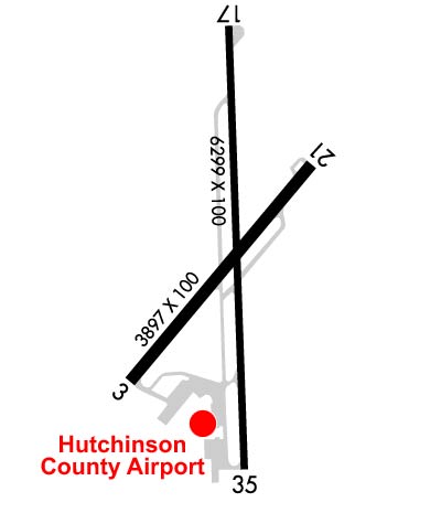
| Lat: N 3542.1 Long: W 10123.6 Elev: 3055 Var: -07 Longest Runway: 6299 | ||
| AWOS: 118.32 CTAF: 123.0 | ||
| |||||||||||||||||||||||||||||||||||||||||||||||||||||||||||||
| |||||||||||||||||||||||||||||||||||||||||||||||||||||||||||||
| |||||||||||||||||||||||||||||||||||||||||||||||||||||||||||||
| Rwy | Rwy | |||||||
| 3897x100 | 3897' | 3897x100 | 3897' | |||||
| 6299x100 | 6299' | 6299x100 | 6299' | |||||
| Runway ID | Single Wheel | Double Wheel | Double Tandem Wheel | Dual Double Wheel |
| 03/21 | 60,000 | 100,000 | N/A | N/A |
| 17/35 | 60,000 | 100,000 | N/A | N/A |
| These numbers are Advisory and are not limits. The Airport Manager should have more accurate Weight Limits | ||||
 Airport Diagram might not be current. | |
| Facility Name: | HUTCHINSON COUNTY |
| City Name: | BORGER |
| County: | HUTCHINSON |
| State abbrev: | TX |
| State Name: | TEXAS |
| Ownership: | PUBLICLY OWNED |
| Use: | OPEN TO THE PUBLIC |
| Owner's Name: | HUTCHINSON COUNTY |
| Address: | COUNTY COURTHOUSE |
| STINNETT, TX 79083 | |
| Owner's Phone: | 806-878-4000 |
| Manager's Name: | BATHAZAR MEDRANO |
| Address: | BOX 3470 |
| BORGER, TX 79008 | |
| Phone: | 806-273-0137 |
| FAA Region: | SOUTHWEST |
| FAA Field Office: | TEX |
| Date | Sunrise | Sunset |
|---|---|---|
| 03/19/25 Wednesday | 7:51 | 19:56 |
| 03/20/25 Thursday | 7:50 | 19:57 |
| 03/21/25 Friday | 7:48 | 19:58 |
| 03/22/25 Saturday | 7:47 | 19:59 |
| 03/23/25 Sunday | 7:45 | 20:00 |
| 03/24/25 Monday | 7:44 | 20:01 |
| 03/25/25 Tuesday | 7:42 | 20:01 |
| 03/26/25 Wednesday | 7:41 | 20:02 |
| 03/27/25 Thursday | 7:40 | 20:03 |
| 03/28/25 Friday | 7:38 | 20:04 |
| 03/29/25 Saturday | 7:37 | 20:05 |
| 03/30/25 Sunday | 7:35 | 20:06 |
| 03/31/25 Monday | 7:34 | 20:06 |
| 04/01/25 Tuesday | 7:32 | 20:07 |
| Airport Attendance Schedule | 7 Days A Week 0800-1800 |
| Airport Status | OPERATIONAL (This Status can change at any time - please check NOTAMS) |
| Airport Lighting Schedule | ACTVT PAPI RWYS 17 & 35; MIRL RWYS 03/21 & 17/35 - CTAF. |
| Airport Storage Available | Tie Downs, Hanger |
| Extra Services Available | Flight Instruction, Aircraft Rental |
| Wind Indicator | YES - (lighted) |
| Control Tower | NO |
| CTAF Frequency | 123.000 |
| Unicom Frequency | 123.000 |
| Rotating Beacon Color | WG |
| Segmented Circle | YES |
| Landing Fee | NO |
| Airport Inspected | STATE - performed by PRIVATE CONTRACT PERSONNEL |
| Inspection Date | 04/10/2024 |
| Type of Fuel Available | Grade 100LL, JET A |
| Airframe Repair Service | None |
| Power Plant Repair Service | None |
| Latitude | N3542.1 |
| Longitude | W10123.6 (ESTIMATED) |
| Arpt Elevation | 3055ft (SURVEYED) |
| Magnetic Variation | 07E |
| 2 miles N | of BORGER |
| Traffic Pattern Altitude | |
| Sectional Chart | DALLAS-FT WORTH |
| Operations (Reported) | Yearly | Avg. Daily |
|---|---|---|
| General Aviation Transient | 0 | 0 |
| General Aviation Local | 0 | 0 |
| Air Taxi | 0 | 0 |
| Commerical | 0 | 0 |
| Commuter | 0 | 0 |
| Military | 0 | 0 |
| Aircraft based on Field | |
|---|---|
| General Aviation Singles | 0 |
| General Aviation Multi | 0 |
| Jet Aircraft | 0 |
| General Aviation Helicopters | 0 |
| Military Aircraft | 0 |
| Gliders | 0 |
| Ultralights | 0 |
| FSS on field | NO |
| FSS tie-in | FORT WORTH |
| FSS Phone | 1-800-WX-BRIEF |
| Who issues Notams | BGD |
| Notam D service at airport | YES |
| ARTCC Name | ALBUQUERQUE |
| Airport Certification | |
| Aircraft Rescue & Firefighting Index | None |
| Airport of Entry | No |
| Custom Landing Rights | No |
| Joint Civil/Military | No |
| Military Landing rights | YES |
| NATIONAL PLAN OF INTEGRATED AIRPORT SYSTEMS (NPIAS) |
| GRANT AGREEMENTS UNDER FAAP/ADAP/AIP |
| ASSURANCES PURSUANT TO TITLE VI, CIVIL RIGHTS ACT OF 1964 |
| FOR CD CTC ALBUQUERQUE ARTCC AT 505-856-4861. |
| RWY 21, 100 FT DROP-OFF, 95 FT DSTC. |
| RWY 3, 40 FT DROP-OFF, 150 FT DSTC. |
Airport Communications & Frequencies:
| |||||||||||||||||||||||
| Runway: 03 | Runway: 21 | ||
| Mag heading: | 33° | Mag heading: | 213° |
| Rwy Slope: | -.46% Down | Rwy Slope: | .46% Up |
| Approach: | Approach: | ||
| Pattern: | Left Traffic | Pattern: | Left Traffic |
| Markings: | BASIC | Markings: | BASIC |
| Marking Condition: | GOOD | Marking Condition: | GOOD |
| Arresting Dev: | Arresting Dev: | ||
| Lat & Long: | N3541.8 W10123.9 | Lat. & Long.: | N3542.3 W10123.4 |
| Elev: | 3035.3 ft. MSL | Elev: | 3017.2 ft. MSL |
| TCH: | TCH: | ||
| Visual Glide Path: | Visual Glide Path: | ||
| Displaced Threshold: | No | Displaced Threshold: | No |
| Touchdown Zone: | YES | Touchdown Zone: | YES |
| Touchdown Elev.: | 3035.5 feet | Touchdown Elev.: | 3025.3 feet |
| Visual Glide Slope: | Visual Glide Slope: | ||
| RVR Equipment: | RVR Equipment: | ||
| RVV Equipment: | NO | RVV Equipment: | NO |
| Approach Lights: | Approach Lights: | ||
| REIL: | NO | REIL: | NO |
| Centerline Lights: | NO | Centerline Lights: | NO |
| Touchdown lights: | NO | Touchdown lights: | NO |
| Runway Category: | Runway with a Visual Approach | Runway Category: | Runway with a Visual Approach |
| Declared Distances: | Declared Distances: | ||
| Comments: | 15 FT TREE, 130 FT DSTC, 95 FT L. | Comments: |
| Runway: 17 | Runway: 35 | ||
| Mag heading: | 171° | Mag heading: | 351° |
| Rwy Slope: | .90% Up | Rwy Slope: | -.90% Down |
| Approach: | Approach: | ||
| Pattern: | Left Traffic | Pattern: | Left Traffic |
| Markings: | NONPRECISION INSTRUMENT | Markings: | NONPRECISION INSTRUMENT |
| Marking Condition: | GOOD | Marking Condition: | GOOD |
| Arresting Dev: | Arresting Dev: | ||
| Lat & Long: | N3542.6 W10123.6 | Lat. & Long.: | N3541.6 W10123.6 |
| Elev: | 2998.3 ft. MSL | Elev: | 3055.2 ft. MSL |
| TCH: | 58 ft. AGL | TCH: | 41 ft. AGL |
| Visual Glide Path: | 3.00 degrees | Visual Glide Path: | 3.00 degrees |
| Displaced Threshold: | No | Displaced Threshold: | No |
| Touchdown Zone: | YES | Touchdown Zone: | YES |
| Touchdown Elev.: | 3013.4 feet | Touchdown Elev.: | 3055.2 feet |
| Visual Glide Slope: | 4-Light PAPI on LEFT side of Runway | Visual Glide Slope: | 4-Light PAPI on RIGHT side of Runway |
| RVR Equipment: | RVR Equipment: | ||
| RVV Equipment: | NO | RVV Equipment: | NO |
| Approach Lights: | Approach Lights: | ||
| REIL: | NO | REIL: | NO |
| Centerline Lights: | NO | Centerline Lights: | NO |
| Touchdown lights: | NO | Touchdown lights: | NO |
| Runway Category: | Runway with a Non-precision Approach having visibility minimums greater than 3/4 mile | Runway Category: | Runway with a Non-precision Approach having visibility minimums greater than 3/4 mile |
| Declared Distances: | Declared Distances: | ||
| Obstructions: | POLE | Obstructions: | TREES |
| Marked: | NOT Marked/Lighted | Marked: | NOT Marked/Lighted |
| Clearance slope: | 1:1 | Clearance slope: | 23:1 |
| Obstruction height: | 18 feet AGL | Obstruction height: | 52 feet AGL |
| Dist. from runway: | 230 feet | Dist. from runway: | 1420 feet |
| Centerline offset: | 408 left of centerline | Centerline offset: | 42 feet right of centerline |
| Comments: | Comments: |
Thanks for using FltPlan.com
all rights reserved © 1999-2025 by Flight Plan LLC