| WEST MICHIGAN REGIONAL HOLLAND MI |
| |
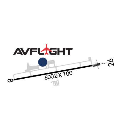
| Lat: N 4244.6 Long: W 08606.5 Elev: 698 Var: +04 Longest Runway: 6002 | ||
| Clr Del: 123.95 AWOS: 119.02 CTAF: 123.05 | ||
| ||||||||||||||||||||||||||||||||||||||||||||||||||||||||||||||||||||
| ||||||||||||||||||||||||||||||||||||||||||||||||||||||||||||||||||||
| Rwy | Rwy | |||||||
| 6002x100 | 6002' | 6002x100 | 6002' | 110.55 - 263° | ||||
| Runway ID | Single Wheel | Double Wheel | Double Tandem Wheel | Dual Double Wheel |
| 08/26 | 75,000 | 160,000 | 175,000 | N/A |
| These numbers are Advisory and are not limits. The Airport Manager should have more accurate Weight Limits | ||||
 Airport Diagram might not be current. | |
| Facility Name: | WEST MICHIGAN RGNL |
| City Name: | HOLLAND |
| County: | ALLEGAN |
| State abbrev: | MI |
| State Name: | MICHIGAN |
| Ownership: | PUBLICLY OWNED |
| Use: | OPEN TO THE PUBLIC |
| Owner's Name: | CITY OF HOLLAND |
| Address: | 270 S. RIVER AVE |
| HOLLAND, MI 49423 | |
| Owner's Phone: | 616-394-1380 |
| Manager's Name: | TERRILL "TERRY" BOER |
| Address: | 1581 S. WASHINGTON AVE |
| HOLLAND, MI 49423 | |
| Phone: | 616-392-7831 |
| FAA Region: | GREAT LAKES |
| FAA Field Office: | DET |
| Date | Sunrise | Sunset |
|---|---|---|
| 09/24/21 Friday | 7:34 | 19:39 |
| 09/25/21 Saturday | 7:35 | 19:37 |
| 09/26/21 Sunday | 7:36 | 19:35 |
| 09/27/21 Monday | 7:37 | 19:33 |
| 09/28/21 Tuesday | 7:38 | 19:31 |
| 09/29/21 Wednesday | 7:39 | 19:30 |
| 09/30/21 Thursday | 7:40 | 19:28 |
| 10/01/21 Friday | 7:41 | 19:26 |
| 10/02/21 Saturday | 7:42 | 19:24 |
| 10/03/21 Sunday | 7:44 | 19:23 |
| 10/04/21 Monday | 7:45 | 19:21 |
| 10/05/21 Tuesday | 7:46 | 19:19 |
| 10/06/21 Wednesday | 7:47 | 19:17 |
| 10/07/21 Thursday | 7:48 | 19:16 |
| Airport Attendance Schedule | MON-FRI 0600-2200, SAT-SUN 0700-2100; FOR ARPT ATTENDANT OTHER HRS & DRG EMERG CALL 616-392-7831. |
| Airport Status | OPERATIONAL (This Status can change at any time - please check NOTAMS) |
| Airport Lighting Schedule | HIRL RWY 08/26 PRESET LOW. TO INCR INTST & ACTVT MALSR RWY 26; REIL RWY 08; PAPI RWY 08 & 26 - CTAF. |
| Airport Storage Available | Tie Downs, Hanger |
| Extra Services Available | Charter, Flight Instruction, Aircraft Rental, Aircraft Sales |
| Wind Indicator | YES - (lighted) |
| Control Tower | NO |
| CTAF Frequency | 123.050 |
| Unicom Frequency | 123.050 |
| Rotating Beacon Color | CLEAR-GREEN (Light Land Airport) |
| Segmented Circle | YES |
| Landing Fee | YES |
| Airport Inspected | STATE - performed by STATE AERONAUTICAL PERSONNEL |
| Inspection Date | 10/24/2019 |
| Type of Fuel Available | Grade 100LL, JET A (freeze point -40C) |
| Airframe Repair Service | MAJOR |
| Power Plant Repair Service | MAJOR |
| Latitude | N4244.6 |
| Longitude | W08606.5 (ESTIMATED) |
| Arpt Elevation | 697ft (SURVEYED) |
| Magnetic Variation | 04W |
| 2 miles S | of HOLLAND |
| Traffic Pattern Altitude | |
| Sectional Chart | CHICAGO |
| Operations (Reported) | Yearly | Avg. Daily |
|---|---|---|
| General Aviation Transient | 16325 | 45 |
| General Aviation Local | 16325 | 45 |
| Air Taxi | 2000 | 5 |
| Commerical | 0 | 0 |
| Commuter | 0 | 0 |
| Military | 350 | 1 |
| Aircraft based on Field | |
|---|---|
| General Aviation Singles | 27 |
| General Aviation Multi | 8 |
| Jet Aircraft | 13 |
| General Aviation Helicopters | 0 |
| Military Aircraft | 0 |
| Gliders | 0 |
| Ultralights | 0 |
| FSS on field | NO |
| FSS tie-in | LANSING |
| FSS Phone | 1-800-WX-BRIEF |
| Who issues Notams | BIV |
| Notam D service at airport | YES |
| ARTCC Name | CHICAGO |
| Airport Certification | |
| Aircraft Rescue & Firefighting Index | None |
| Airport of Entry | No |
| Custom Landing Rights | No |
| Joint Civil/Military | No |
| Military Landing rights | No |
| NATIONAL PLAN OF INTEGRATED AIRPORT SYSTEMS (NPIAS) |
| GRANT AGREEMENTS UNDER FAAP/ADAP/AIP |
| ASSURANCES PURSUANT TO TITLE VI, CIVIL RIGHTS ACT OF 1964 |
| RADIO CALL, "HOLLAND." |
| FOR CD WHEN GREAT LAKES APCH CLSD CTC CHICAGO ARTCC AT 630-906-8921. |
| TNST ACFT CALL AHEAD FOR HNGR STORAGE. |
Airport Communications & Frequencies:
| |||||||||||||||||||
| Runway: 08 | Runway: 26 | ||
| Mag heading: | 84° | Mag heading: | 264° |
| Rwy Slope: | -.20% Down | Rwy Slope: | .20% Up |
| Approach: | Approach: | ILS/DME | |
| Pattern: | Right Traffic | Pattern: | Left Traffic |
| Markings: | PRECISION INSTRUMENT | Markings: | PRECISION INSTRUMENT |
| Marking Condition: | GOOD | Marking Condition: | GOOD |
| Arresting Dev: | Arresting Dev: | ||
| Lat & Long: | N4244.5 W08607.1 | Lat. & Long.: | N4244.7 W08605.8 |
| Elev: | 697.9 ft. MSL | Elev: | 685.8 ft. MSL |
| TCH: | 40 ft. AGL | TCH: | 33 ft. AGL |
| Visual Glide Path: | 3.00 degrees | Visual Glide Path: | 3.00 degrees |
| Displaced Threshold: | No | Displaced Threshold: | No |
| Touchdown Zone: | YES | Touchdown Zone: | YES |
| Touchdown Elev.: | 697.9 feet | Touchdown Elev.: | 685.8 feet |
| Visual Glide Slope: | 4-Light PAPI on LEFT side of Runway | Visual Glide Slope: | 4-Light PAPI on LEFT side of Runway |
| RVR Equipment: | RVR Equipment: | ||
| RVV Equipment: | NO | RVV Equipment: | NO |
| Approach Lights: | Approach Lights: | MALSR - 1,400 foot medium intensity approach lighting system with runway alignment indicator lights | |
| REIL: | YES | REIL: | NO |
| Centerline Lights: | NO | Centerline Lights: | NO |
| Touchdown lights: | NO | Touchdown lights: | NO |
| Runway Category: | Runway with a Non-precision Approach having visibility minimums greater than 3/4 mile | Runway Category: | Precision Instrument Runway |
| Declared Distances: | Declared Distances: | ||
| Obstructions: | TREE | Obstructions: | |
| Marked: | NOT Marked/Lighted | Marked: | |
| Clearance slope: | 34:1 | Clearance slope: | 50:1 |
| Obstruction height: | 67 feet AGL | Obstruction height: | |
| Dist. from runway: | 2500 feet | Dist. from runway: | |
| Centerline offset: | 250 right of centerline | Centerline offset: | |
| Comments: | Comments: |
Thanks for using FltPlan.com
all rights reserved © 1999-2021 by Flight Plan LLC