
| SOUTHEAST IOWA RGNL BURLINGTON IA |
| |
| Lat: N 4047.0 Long: W 09107.5 Elev: 699 Var: +00 Longest Runway: 6102 | ||
| AWOS: 118.02 CTAF: 123.0 | ||
| ||||||||||||||||||||||||||||||||||||||||||||
| ||||||||||||||||||||||||||||||||||||||||||||
| ||||||||||||||||||||||||||||||||||||||||||||
| Rwy | Rwy | |||||||
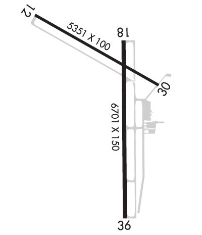
| 5351x100 | 5351' | 5351x100 | 4851' | |||||
| 6102x100 | 6102' | 6102x100 | 6102' | 108.90 - 358° | ||||
| Runway ID | Single Wheel | Double Wheel | Double Tandem Wheel | Dual Double Wheel |
| 12/30 | 37,000 | 58,000 | N/A | N/A |
| 18/36 | 65,000 | 90,000 | N/A | N/A |
| These numbers are Advisory and are not limits. The Airport Manager should have more accurate Weight Limits | ||||
 Airport Diagram might not be current. | |
| Facility Name: | SOUTHEAST IOWA RGNL |
| City Name: | BURLINGTON |
| County: | DES MOINES |
| State abbrev: | IA |
| State Name: | IOWA |
| Ownership: | PUBLICLY OWNED |
| Use: | OPEN TO THE PUBLIC |
| Owner's Name: | SE IOWA REG ARPT AUTHORITY |
| Address: | 2515 SUMMER STREET |
| BURLINGTON, IA 52601-3330 | |
| Owner's Phone: | 319-754-1414; FAX 319-754-1424. |
| Manager's Name: | SARA SANDBURG |
| Address: | 2515 SUMMER ST |
| BURLINGTON, IA 52601 | |
| Phone: | 319-754-1414 |
| FAA Region: | CENTRAL |
| FAA Field Office: | NONE |
| Date | Sunrise | Sunset |
|---|---|---|
| 09/24/21 Friday | 6:54 | 18:59 |
| 09/25/21 Saturday | 6:55 | 18:57 |
| 09/26/21 Sunday | 6:56 | 18:55 |
| 09/27/21 Monday | 6:57 | 18:54 |
| 09/28/21 Tuesday | 6:58 | 18:52 |
| 09/29/21 Wednesday | 6:59 | 18:50 |
| 09/30/21 Thursday | 7:00 | 18:49 |
| 10/01/21 Friday | 7:01 | 18:47 |
| 10/02/21 Saturday | 7:02 | 18:45 |
| 10/03/21 Sunday | 7:03 | 18:44 |
| 10/04/21 Monday | 7:04 | 18:42 |
| 10/05/21 Tuesday | 7:05 | 18:40 |
| 10/06/21 Wednesday | 7:06 | 18:39 |
| 10/07/21 Thursday | 7:07 | 18:37 |
| Airport Attendance Schedule | 7 Days A Week 0700-1900 |
| Airport Status | OPERATIONAL (This Status can change at any time - please check NOTAMS) |
| Airport Lighting Schedule | ACTVT MIRL RY 12/30; HIRL RY 18/36; VASI RY 12; PAPI RY 18 & RY 30; REIL RYS 12 & 30 & MALSR RY 36 - CTAF. |
| Airport Storage Available | Tie Downs, Hanger |
| Extra Services Available | Charter, Flight Instruction, Aircraft Rental |
| Wind Indicator | YES - (lighted) |
| Control Tower | NO |
| CTAF Frequency | 123.000 |
| Unicom Frequency | 123.000 |
| Rotating Beacon Color | CLEAR-GREEN (Light Land Airport) |
| Segmented Circle | YES |
| Landing Fee | NO |
| Airport Inspected | FEDERAL - performed by STATE AERONAUTICAL PERSONNEL |
| Inspection Date | 07/30/2019 |
| Type of Fuel Available | Grade 100LL, JET A (freeze point -40C) |
| Airframe Repair Service | MAJOR |
| Power Plant Repair Service | MAJOR |
| Latitude | N4047.0 |
| Longitude | W09107.5 (ESTIMATED) |
| Arpt Elevation | 698ft (SURVEYED) |
| Magnetic Variation | 00W |
| 2 miles SW | of BURLINGTON |
| Traffic Pattern Altitude | |
| Sectional Chart | CHICAGO |
| Operations (Reported) | Yearly | Avg. Daily |
|---|---|---|
| General Aviation Transient | 9000 | 25 |
| General Aviation Local | 6000 | 16 |
| Air Taxi | 3200 | 9 |
| Commerical | 1872 | 5 |
| Commuter | 0 | 0 |
| Military | 100 | 0 |
| Aircraft based on Field | |
|---|---|
| General Aviation Singles | 28 |
| General Aviation Multi | 2 |
| Jet Aircraft | 1 |
| General Aviation Helicopters | 1 |
| Military Aircraft | 0 |
| Gliders | 0 |
| Ultralights | 0 |
| FSS on field | NO |
| FSS tie-in | FORT DODGE |
| FSS Phone | 1-800-WX-BRIEF |
| Who issues Notams | BRL |
| Notam D service at airport | YES |
| ARTCC Name | CHICAGO |
| Airport Certification | |
| Aircraft Rescue & Firefighting Index | None |
| Airport of Entry | No |
| Custom Landing Rights | No |
| Joint Civil/Military | No |
| Military Landing rights | YES |
| NATIONAL PLAN OF INTEGRATED AIRPORT SYSTEMS (NPIAS) |
| GRANT AGREEMENTS UNDER FAAP/ADAP/AIP |
| ASSURANCES PURSUANT TO TITLE VI, CIVIL RIGHTS ACT OF 1964 |
| AGREEMENT UNDER DLAND OR DCLA HAS EXPIRED. |
| LINE OF SIGHT VISION BLOCKED BETWEEN RYS 36 & 12. |
| RY 36 IS CALM WIND RY. |
| SELF SERVICE FUEL STATION AVAILABLE ON NORTH END OF APRON. |
| SFC CONDITIONS UNMNT BTN 0300-1300 DLY. |
| COLD TEMPERATURE RESTRICTED AIRPORT. ALTITUDE CORRECTION REQUIRED AT OR BELOW -28C/-18F. |
| FOR CD IF UNA TO CTC ON FSS FREQ, CTC CHICAGO ARTCC AT 630-906-8921. |
Airport Communications & Frequencies:
| |||||||||
| Runway: 12 | Runway: 30 | ||
| Mag heading: | 120° | Mag heading: | 300° |
| Rwy Slope: | .10% Up | Rwy Slope: | -.10% Down |
| Approach: | Approach: | ||
| Pattern: | Right Traffic | Pattern: | Left Traffic |
| Markings: | NONPRECISION INSTRUMENT | Markings: | NONPRECISION INSTRUMENT |
| Marking Condition: | GOOD | Marking Condition: | GOOD |
| Arresting Dev: | Arresting Dev: | ||
| Lat & Long: | N4047.5 W09108.2 | Lat. & Long.: | N4047.0 W09107.2 |
| Elev: | 692.7 ft. MSL | Elev: | 698.1 ft. MSL |
| TCH: | 39 ft. AGL | TCH: | 30 ft. AGL |
| Visual Glide Path: | 3.00 degrees | Visual Glide Path: | 3.00 degrees |
| Displaced Threshold: | No | Displaced Threshold: | 500 feet |
| Touchdown Zone: | YES | Touchdown Zone: | YES |
| Touchdown Elev.: | 692.7 feet | Touchdown Elev.: | 697.1 feet |
| Visual Glide Slope: | 4-BOX VASI ON LEFT SIDE OF RUNWAY | Visual Glide Slope: | 4-Light PAPI on LEFT side of Runway |
| RVR Equipment: | RVR Equipment: | ||
| RVV Equipment: | NO | RVV Equipment: | NO |
| Approach Lights: | Approach Lights: | ||
| REIL: | YES | REIL: | YES |
| Centerline Lights: | NO | Centerline Lights: | NO |
| Touchdown lights: | NO | Touchdown lights: | NO |
| Runway Category: | Runway with a Non-precision Approach having visibility minimums greater than 3/4 mile | Runway Category: | Runway with a Non-precision Approach having visibility minimums greater than 3/4 mile |
| Declared Distances: | TORA:4850' TODA:5350' ASDA:4850' LDA:5350' | Declared Distances: | TORA:5350' TODA:5350' ASDA:5350' LDA:4850' |
| Obstructions: | Obstructions: | ROAD | |
| Marked: | Marked: | NOT Marked/Lighted | |
| Clearance slope: | 50:1 | Clearance slope: | 25:1 |
| Obstruction height: | Obstruction height: | 16 feet AGL | |
| Dist. from runway: | Dist. from runway: | 600 feet | |
| Centerline offset: | Centerline offset: | 300 feet right of centerline | |
| Comments: | Comments: |
| Runway: 18 | Runway: 36 | ||
| Mag heading: | 180° | Mag heading: | 360° |
| Rwy Slope: | -.29% Down | Rwy Slope: | .29% Up |
| Approach: | Approach: | ILS | |
| Pattern: | Right Traffic | Pattern: | Left Traffic |
| Markings: | NONPRECISION INSTRUMENT | Markings: | PRECISION INSTRUMENT |
| Marking Condition: | GOOD | Marking Condition: | GOOD |
| Arresting Dev: | Arresting Dev: | ||
| Lat & Long: | N4047.2 W09107.4 | Lat. & Long.: | N4046.2 W09107.4 |
| Elev: | 695.5 ft. MSL | Elev: | 677.5 ft. MSL |
| TCH: | 40 ft. AGL | TCH: | |
| Visual Glide Path: | 3.00 degrees | Visual Glide Path: | |
| Displaced Threshold: | No | Displaced Threshold: | No |
| Touchdown Zone: | YES | Touchdown Zone: | YES |
| Touchdown Elev.: | 698.8 feet | Touchdown Elev.: | 695.2 feet |
| Visual Glide Slope: | 4-Light PAPI on LEFT side of Runway | Visual Glide Slope: | |
| RVR Equipment: | RVR Equipment: | ||
| RVV Equipment: | NO | RVV Equipment: | NO |
| Approach Lights: | Approach Lights: | MALSR - 1,400 foot medium intensity approach lighting system with runway alignment indicator lights | |
| REIL: | NO | REIL: | NO |
| Centerline Lights: | NO | Centerline Lights: | NO |
| Touchdown lights: | NO | Touchdown lights: | NO |
| Runway Category: | Runway with a Visual Approach | Runway Category: | Precision Instrument Runway |
| Declared Distances: | TORA:6102' TODA:6102' ASDA:6102' LDA:6102' | Declared Distances: | TORA:6102' TODA:6102' ASDA:6102' LDA:6102' |
| Obstructions: | TREES | Obstructions: | TREE |
| Marked: | NOT Marked/Lighted | Marked: | NOT Marked/Lighted |
| Clearance slope: | 15:1; RWY 18 APCH RATIO 25:1 FM DSPLCD THR. | Clearance slope: | 45:1 |
| Obstruction height: | 85 feet AGL | Obstruction height: | 40 feet AGL |
| Dist. from runway: | 1500 feet | Dist. from runway: | 2000 feet |
| Centerline offset: | Centerline offset: | 575 feet left of centerline | |
| Comments: | Comments: |
Thanks for using FltPlan.com
all rights reserved © 1999-2021 by Flight Plan LLC
