
| BATESVILLE RGNL BATESVILLE AR |
| |
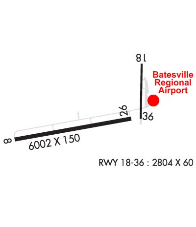
| Lat: N 3543.6 Long: W 09138.8 Elev: 465 Var: -01 Longest Runway: 6002 | ||
| AWOS: 126.37 CTAF: 122.8 | ||
| ||||||||||||||||||||||||||||||||||||||||||||
| ||||||||||||||||||||||||||||||||||||||||||||
| ||||||||||||||||||||||||||||||||||||||||||||
| Rwy | Rwy | |||||||
| 6002x150 | 6002' | 109.70 - 078° | 6002x150 | 6002' | ||||
| 2804x60 | 2804' | 2804x60 | 2804' | |||||
| Runway ID | Single Wheel | Double Wheel | Double Tandem Wheel | Dual Double Wheel |
| 08/26 | 30,000 | 105,000 | 195,000 | N/A |
| 18/36 | 30,000 | 105,000 | N/A | N/A |
| These numbers are Advisory and are not limits. The Airport Manager should have more accurate Weight Limits | ||||
 Airport Diagram might not be current. | |
| Facility Name: | BATESVILLE RGNL |
| City Name: | BATESVILLE |
| County: | INDEPENDENCE |
| State abbrev: | AR |
| State Name: | ARKANSAS |
| Ownership: | PUBLICLY OWNED |
| Use: | OPEN TO THE PUBLIC |
| Owner's Name: | CITY OF BATESVILLE |
| Address: | 500 EAST MAIN ST. |
| BATESVILLE, AR 72501 | |
| Owner's Phone: | 870-698-2400 |
| Manager's Name: | JUSTIN THOMPSON |
| Address: | 1126 BATESVILLE BLVD |
| BATESVILLE, AR 72501 | |
| Phone: | 870-251-1244 |
| FAA Region: | SOUTHWEST |
| FAA Field Office: | AOK |
| Date | Sunrise | Sunset |
|---|---|---|
| 04/18/25 Friday | 6:30 | 19:42 |
| 04/19/25 Saturday | 6:29 | 19:43 |
| 04/20/25 Sunday | 6:28 | 19:44 |
| 04/21/25 Monday | 6:26 | 19:45 |
| 04/22/25 Tuesday | 6:25 | 19:46 |
| 04/23/25 Wednesday | 6:24 | 19:46 |
| 04/24/25 Thursday | 6:23 | 19:47 |
| 04/25/25 Friday | 6:22 | 19:48 |
| 04/26/25 Saturday | 6:20 | 19:49 |
| 04/27/25 Sunday | 6:19 | 19:50 |
| 04/28/25 Monday | 6:18 | 19:51 |
| 04/29/25 Tuesday | 6:17 | 19:51 |
| 04/30/25 Wednesday | 6:16 | 19:52 |
| 05/01/25 Thursday | 6:15 | 19:53 |
| Airport Attendance Schedule | 7 Days A Week 0730-1730, 7 Days A Week 1730-0730; CALL OUT FEE APPLIES |
| Airport Status | OPERATIONAL (This Status can change at any time - please check NOTAMS) |
| Airport Lighting Schedule | ACTVT REIL RWYS 08 & 26 AND MIRL RWY 08/26 - CTAF. |
| Airport Storage Available | Tie Downs, Hanger |
| Extra Services Available | Air Ambulance, Flight Instruction, Aircraft Rental |
| Wind Indicator | YES - (lighted) |
| Control Tower | NO |
| CTAF Frequency | 122.800 |
| Unicom Frequency | 122.800 |
| Rotating Beacon Color | WG |
| Segmented Circle | YES |
| Landing Fee | NO |
| Airport Inspected | STATE - performed by STATE AERONAUTICAL PERSONNEL |
| Inspection Date | 10/24/2023 |
| Type of Fuel Available | Grade 100LL, JET A; -10100LL SELF SVC AVBL WITH CREDIT CARD. FOR SVC AFTER HRS CALL 870-251-1244, FEE CHRGD.; -A+JET A+ SELF SERVE UNAVAILABLE |
| Airframe Repair Service | MAJOR |
| Power Plant Repair Service | MAJOR |
| Latitude | N3543.6 |
| Longitude | W09138.8 (ESTIMATED) |
| Arpt Elevation | 465ft (SURVEYED) |
| Magnetic Variation | 01E |
| 3 miles S | of BATESVILLE |
| Traffic Pattern Altitude | 785 |
| Sectional Chart | MEMPHIS |
| Operations (Reported) | Yearly | Avg. Daily |
|---|---|---|
| General Aviation Transient | 0 | 0 |
| General Aviation Local | 0 | 0 |
| Air Taxi | 0 | 0 |
| Commerical | 0 | 0 |
| Commuter | 0 | 0 |
| Military | 0 | 0 |
| Aircraft based on Field | |
|---|---|
| General Aviation Singles | 0 |
| General Aviation Multi | 0 |
| Jet Aircraft | 0 |
| General Aviation Helicopters | 0 |
| Military Aircraft | 0 |
| Gliders | 0 |
| Ultralights | 0 |
| FSS on field | NO |
| FSS tie-in | JONESBORO |
| FSS Phone | 1-800-WX-BRIEF |
| Who issues Notams | BVX |
| Notam D service at airport | YES |
| ARTCC Name | MEMPHIS |
| Airport Certification | |
| Aircraft Rescue & Firefighting Index | None |
| Airport of Entry | No |
| Custom Landing Rights | No |
| Joint Civil/Military | No |
| Military Landing rights | YES |
| NATIONAL PLAN OF INTEGRATED AIRPORT SYSTEMS (NPIAS) |
| GRANT AGREEMENTS UNDER FAAP/ADAP/AIP |
| ASSURANCES PURSUANT TO TITLE VI, CIVIL RIGHTS ACT OF 1964 |
| THIS AIRPORT HAS BEEN SURVEYED BY THE NATIONAL GEODETIC SURVEY. |
| FOR CD CTC MEMPHIS ARTCC AT 901-368-8453/8449. |
| RWY 08/2 6 (S) TAXIWAYS LIMITED TO 31K - APRONS LIMITED TO 29K |
| RWY 18/3 6 (S) TAXIWAYS LIMITED TO 31K - APRONS LIMITED TO 29K |
| RWY 08/2 6 (D) TAXIWAYS LIMITED TO 77K - APRONS LIMITED TO 67K |
| RWY 18/3 6 (D) TAXIWAYS LIMITED TO 77K - APRONS LIMITED TO 67K |
| RWY 08/2 6 (2D) TAXIWAYS LIMITED TO 204K - APRONS LIMITED TO 184K |
Airport Communications & Frequencies:
| |||||||||
| Runway: 08 | Runway: 26 | ||
| Mag heading: | 79° | Mag heading: | 259° |
| Rwy Slope: | .21% Up | Rwy Slope: | -.21% Down |
| Approach: | LOC/DME | Approach: | |
| Pattern: | Left Traffic | Pattern: | Left Traffic |
| Markings: | NONPRECISION INSTRUMENT | Markings: | NONPRECISION INSTRUMENT |
| Marking Condition: | GOOD | Marking Condition: | GOOD |
| Arresting Dev: | Arresting Dev: | ||
| Lat & Long: | N3543.4 W09139.7 | Lat. & Long.: | N3543.6 W09138.5 |
| Elev: | 452.2 ft. MSL | Elev: | 464.6 ft. MSL |
| TCH: | 44 ft. AGL | TCH: | 45 ft. AGL |
| Visual Glide Path: | 3.00 degrees | Visual Glide Path: | 3.00 degrees |
| Displaced Threshold: | No | Displaced Threshold: | No |
| Touchdown Zone: | YES | Touchdown Zone: | YES |
| Touchdown Elev.: | 463.0 feet | Touchdown Elev.: | 465.0 feet |
| Visual Glide Slope: | 2-Light PAPI on LEFT side of Runway | Visual Glide Slope: | 2-Light PAPI on LEFT side of Runway |
| RVR Equipment: | RVR Equipment: | ||
| RVV Equipment: | NO | RVV Equipment: | NO |
| Approach Lights: | Approach Lights: | ||
| REIL: | YES | REIL: | YES |
| Centerline Lights: | NO | Centerline Lights: | NO |
| Touchdown lights: | NO | Touchdown lights: | NO |
| Runway Category: | Runway with a Non-precision Approach having visibility minimums greater than 3/4 mile | Runway Category: | Runway with a Non-precision Approach having visibility minimums greater than 3/4 mile |
| Declared Distances: | Declared Distances: | ||
| Obstructions: | Obstructions: | TREE | |
| Marked: | Marked: | NOT Marked/Lighted | |
| Clearance slope: | 50:1 | Clearance slope: | 35:1 |
| Obstruction height: | Obstruction height: | 32 feet AGL | |
| Dist. from runway: | Dist. from runway: | 1320 feet | |
| Centerline offset: | Centerline offset: | ||
| Comments: | Comments: |
| Runway: 18 | Runway: 36 | ||
| Mag heading: | 180° | Mag heading: | 0° |
| Rwy Slope: | .89% Up | Rwy Slope: | -.89% Down |
| Approach: | Approach: | ||
| Pattern: | Left Traffic | Pattern: | Left Traffic |
| Markings: | BASIC | Markings: | BASIC |
| Marking Condition: | GOOD | Marking Condition: | GOOD |
| Arresting Dev: | Arresting Dev: | ||
| Lat & Long: | N3544.0 W09138.4 | Lat. & Long.: | N3543.6 W09138.4 |
| Elev: | 435.4 ft. MSL | Elev: | 460.4 ft. MSL |
| TCH: | TCH: | ||
| Visual Glide Path: | Visual Glide Path: | ||
| Displaced Threshold: | No | Displaced Threshold: | No |
| Touchdown Zone: | YES | Touchdown Zone: | YES |
| Touchdown Elev.: | 460.4 feet | Touchdown Elev.: | 460.4 feet |
| Visual Glide Slope: | Visual Glide Slope: | ||
| RVR Equipment: | RVR Equipment: | ||
| RVV Equipment: | NO | RVV Equipment: | NO |
| Approach Lights: | Approach Lights: | ||
| REIL: | NO | REIL: | NO |
| Centerline Lights: | NO | Centerline Lights: | NO |
| Touchdown lights: | NO | Touchdown lights: | NO |
| Runway Category: | Runway with a Visual Approach | Runway Category: | Runway with a Visual Approach |
| Declared Distances: | Declared Distances: | ||
| Obstructions: | TREE | Obstructions: | ROAD |
| Marked: | NOT Marked/Lighted | Marked: | NOT Marked/Lighted |
| Clearance slope: | 13:1 | Clearance slope: | 7:1 |
| Obstruction height: | 45 feet AGL | Obstruction height: | 10 feet AGL |
| Dist. from runway: | 800 feet | Dist. from runway: | 275 feet |
| Centerline offset: | 180 right of centerline | Centerline offset: | |
| Comments: | Comments: |
Thanks for using FltPlan.com
all rights reserved © 1999-2025 by Flight Plan LLC
