| CARIBOU MUNI CARIBOU ME |
| |
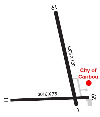
| Lat: N 4652.3 Long: W 06801.1 Elev: 620 Var: +17 Longest Runway: 4003 | ||
| Clr Del: 124.75 AWOS: 135.12 CTAF: 122.8 | ||
| |||||||||||||||||||||||
| |||||||||||||||||||||||
| |||||||||||||||||||||||
| Rwy | Rwy | |||||||
| 4003x100 | 4003' | 4003x100 | 4003' | |||||
| 3016x75 | 3016' | 3016x75 | 2618' | |||||
| Runway ID | Single Wheel | Double Wheel | Double Tandem Wheel | Dual Double Wheel |
| 01/19 | 30,000 | N/A | N/A | N/A |
| 11/29 | 30,000 | N/A | N/A | N/A |
| These numbers are Advisory and are not limits. The Airport Manager should have more accurate Weight Limits | ||||
 Airport Diagram might not be current. | |
| Facility Name: | CARIBOU MUNI |
| City Name: | CARIBOU |
| County: | AROOSTOOK |
| State abbrev: | ME |
| State Name: | MAINE |
| Ownership: | PUBLICLY OWNED |
| Use: | OPEN TO THE PUBLIC |
| Owner's Name: | CITY OF CARIBOU |
| Address: | 25 HIGH STREET |
| CARIBOU, ME 04736 | |
| Owner's Phone: | 207-493-3324 |
| Manager's Name: | DENNIS MARKER |
| Address: | 25 HIGH STREET |
| CARIBOU, ME 04736 | |
| Phone: | 207-493-3324 |
| FAA Region: | NEW ENGLAND |
| FAA Field Office: | NONE |
| Date | Sunrise | Sunset |
|---|---|---|
| 09/24/21 Friday | 6:21 | 18:26 |
| 09/25/21 Saturday | 6:22 | 18:24 |
| 09/26/21 Sunday | 6:24 | 18:22 |
| 09/27/21 Monday | 6:25 | 18:20 |
| 09/28/21 Tuesday | 6:26 | 18:18 |
| 09/29/21 Wednesday | 6:28 | 18:16 |
| 09/30/21 Thursday | 6:29 | 18:14 |
| 10/01/21 Friday | 6:30 | 18:12 |
| 10/02/21 Saturday | 6:32 | 18:10 |
| 10/03/21 Sunday | 6:33 | 18:08 |
| 10/04/21 Monday | 6:34 | 18:06 |
| 10/05/21 Tuesday | 6:36 | 18:04 |
| 10/06/21 Wednesday | 6:37 | 18:02 |
| 10/07/21 Thursday | 6:39 | 18:01 |
| Airport Attendance Schedule | 7 Days A Week UNATNDD |
| Airport Status | OPERATIONAL (This Status can change at any time - please check NOTAMS) |
| Airport Lighting Schedule | ACTVT MIRL RWY 01/19 & 11/29 - CTAF. |
| Airport Storage Available | Tie Downs, Hanger |
| Extra Services Available | Air Ambulance |
| Wind Indicator | YES - (lighted) |
| Control Tower | NO |
| CTAF Frequency | 122.800 |
| Unicom Frequency | 122.800 |
| Rotating Beacon Color | CLEAR-GREEN (Light Land Airport) |
| Segmented Circle | YES |
| Landing Fee | NO |
| Airport Inspected | STATE - performed by PRIVATE CONTRACT PERSONNEL |
| Inspection Date | 08/13/2018 |
| Type of Fuel Available | Grade 100LL; -1024 HR FUEL AVBL WITH CREDIT CARD. |
| Airframe Repair Service | NONE |
| Power Plant Repair Service | NONE |
| Latitude | N4652.3 |
| Longitude | W06801.1 (ESTIMATED) |
| Arpt Elevation | 620ft (SURVEYED) |
| Magnetic Variation | 17W |
| 1 miles NW | of CARIBOU |
| Traffic Pattern Altitude | 800; 800 FT AGL LGT ACFT; 1000 FT AGL MULTI & LRG SNGL ENG ACFT. |
| Sectional Chart | HALIFAX |
| Operations (Reported) | Yearly | Avg. Daily |
|---|---|---|
| General Aviation Transient | 1200 | 3 |
| General Aviation Local | 2000 | 5 |
| Air Taxi | 0 | 0 |
| Commerical | 0 | 0 |
| Commuter | 0 | 0 |
| Military | 0 | 0 |
| Aircraft based on Field | |
|---|---|
| General Aviation Singles | 10 |
| General Aviation Multi | 0 |
| Jet Aircraft | 0 |
| General Aviation Helicopters | 0 |
| Military Aircraft | 0 |
| Gliders | 0 |
| Ultralights | 0 |
| FSS on field | NO |
| FSS tie-in | BANGOR |
| FSS Phone | 1-800-WX-BRIEF |
| Who issues Notams | CAR |
| Notam D service at airport | YES |
| ARTCC Name | BOSTON |
| Airport Certification | |
| Aircraft Rescue & Firefighting Index | None |
| Airport of Entry | YES |
| Custom Landing Rights | No |
| Joint Civil/Military | No |
| Military Landing rights | YES |
| NATIONAL PLAN OF INTEGRATED AIRPORT SYSTEMS (NPIAS) |
| GRANT AGREEMENTS UNDER FAAP/ADAP/AIP |
| ASSURANCES PURSUANT TO TITLE VI, CIVIL RIGHTS ACT OF 1964 |
| RWY 01/19 OBSTN LGTS ALG BOTH SIDES OF PRIM SFC AND TREE LN. |
| RWY 01 +23 FT PWR POLE AND TREES APRXLY 950 FT FM THR ACRS APCH. |
| FOR CD IF UNA TO CTC ON FSS FREQ, CTC BOSTON ARTCC AT 603-879-6859 . |
Airport Communications & Frequencies:
| |||||||||
| Runway: 01 | Runway: 19 | ||
| Mag heading: | 4° | Mag heading: | 184° |
| Rwy Slope: | .08% Up | Rwy Slope: | -.08% Down |
| Approach: | Approach: | ||
| Pattern: | Left Traffic | Pattern: | Left Traffic |
| Markings: | NONPRECISION INSTRUMENT | Markings: | NONPRECISION INSTRUMENT |
| Marking Condition: | GOOD | Marking Condition: | GOOD |
| Arresting Dev: | Arresting Dev: | ||
| Lat & Long: | N4652.1 W06800.9 | Lat. & Long.: | N4652.7 W06801.1 |
| Elev: | 614.1 ft. MSL | Elev: | 617.3 ft. MSL |
| TCH: | TCH: | ||
| Visual Glide Path: | Visual Glide Path: | ||
| Displaced Threshold: | No | Displaced Threshold: | No |
| Touchdown Zone: | YES | Touchdown Zone: | YES |
| Touchdown Elev.: | 620.1 feet | Touchdown Elev.: | 620.1 feet |
| Visual Glide Slope: | Visual Glide Slope: | ||
| RVR Equipment: | RVR Equipment: | ||
| RVV Equipment: | NO | RVV Equipment: | NO |
| Approach Lights: | Approach Lights: | ||
| REIL: | NO | REIL: | NO |
| Centerline Lights: | NO | Centerline Lights: | NO |
| Touchdown lights: | NO | Touchdown lights: | NO |
| Runway Category: | Runway with a Visual Approach | Runway Category: | Runway with a Non-precision Approach having visibility minimums greater than 3/4 mile |
| Declared Distances: | Declared Distances: | ||
| Obstructions: | GND | Obstructions: | |
| Marked: | NOT Marked/Lighted | Marked: | |
| Clearance slope: | 1:1 | Clearance slope: | 50:1 |
| Obstruction height: | 7 feet AGL | Obstruction height: | |
| Dist. from runway: | 201 feet | Dist. from runway: | |
| Centerline offset: | 149 right of centerline | Centerline offset: | |
| Comments: | RWY 01 GND, 0-200 FT FM EOR 100 FT TO 250 FT RIGHT OF CNTRLN RSG TO +8 FT. | Comments: |
| Runway: 11 | Runway: 29 | ||
| Mag heading: | 104° | Mag heading: | 285° |
| Rwy Slope: | -.02% Down | Rwy Slope: | .02% Up |
| Approach: | Approach: | ||
| Pattern: | Left Traffic | Pattern: | Left Traffic |
| Markings: | BASIC | Markings: | BASIC |
| Marking Condition: | GOOD | Marking Condition: | GOOD |
| Arresting Dev: | Arresting Dev: | ||
| Lat & Long: | N4652.1 W06801.6 | Lat. & Long.: | N4652.2 W06800.8 |
| Elev: | 620.0 ft. MSL | Elev: | 619.3 ft. MSL |
| TCH: | TCH: | ||
| Visual Glide Path: | Visual Glide Path: | ||
| Displaced Threshold: | No | Displaced Threshold: | 398 feet |
| Touchdown Zone: | YES | Touchdown Zone: | YES |
| Touchdown Elev.: | 620.3 feet | Touchdown Elev.: | 620.3 feet |
| Visual Glide Slope: | Visual Glide Slope: | ||
| RVR Equipment: | RVR Equipment: | ||
| RVV Equipment: | NO | RVV Equipment: | NO |
| Approach Lights: | Approach Lights: | ||
| REIL: | NO | REIL: | NO |
| Centerline Lights: | NO | Centerline Lights: | NO |
| Touchdown lights: | NO | Touchdown lights: | NO |
| Runway Category: | Runway with a Visual Approach | Runway Category: | Runway with a Visual Approach; RWY 29 HAS 524 FT DSPLCD THLD; +302 FT BLAST PAD BYD END OF RWY. |
| Declared Distances: | Declared Distances: | ||
| Obstructions: | Obstructions: | BLDG | |
| Marked: | Marked: | LIGHTED | |
| Clearance slope: | 50:1 | Clearance slope: | 5:1; RWY 29 HAS 24:1 RATIO TO DSPLCD THR. |
| Obstruction height: | Obstruction height: | 34 feet AGL | |
| Dist. from runway: | Dist. from runway: | 398 feet | |
| Centerline offset: | Centerline offset: | 95 feet right of centerline | |
| Comments: | Comments: | GND ON BOTH SIDES RSG TO +3 FT 200 FT FM RWY END. |
Thanks for using FltPlan.com
all rights reserved © 1999-2021 by Flight Plan LLC