
| NEWNAN COWETA COUNTY ATLANTA GA |
| |
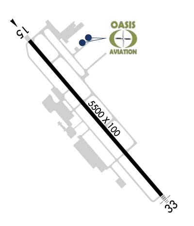
| Lat: N 3318.7 Long: W 08446.2 Elev: 970 Var: +03 Longest Runway: 5500 | ||
| Clr Del: 119.8 AWOS: 118.97 CTAF: 122.7 | ||
| ||||||||||||||||||||||||||||||||||||||||||||
| ||||||||||||||||||||||||||||||||||||||||||||
| ||||||||||||||||||||||||||||||||||||||||||||
| ||||||||||||||||||||||||||||||||||||||||||||
| Rwy | Rwy | |||||||
| 5500x100 | 5500' | 5500x100 | 5500' | 110.75 - 322° | ||||
| Runway ID | Single Wheel | Double Wheel | Double Tandem Wheel | Dual Double Wheel |
| 15/33 | 26,000 | 37,000 | N/A | N/A |
| These numbers are Advisory and are not limits. The Airport Manager should have more accurate Weight Limits | ||||
 Airport Diagram might not be current. | |
| Facility Name: | NEWNAN COWETA COUNTY |
| City Name: | ATLANTA |
| County: | COWETA |
| State abbrev: | GA |
| State Name: | GEORGIA |
| Ownership: | PUBLICLY OWNED |
| Use: | OPEN TO THE PUBLIC |
| Owner's Name: | NEWNAN & COWETA CO ARPT AUTH |
| Address: | 115 AIRPORT ROAD, BOX 2 |
| NEWNAN, GA 30263 | |
| Owner's Phone: | 770-254-8102 |
| Manager's Name: | CALVIN WALKER |
| Address: | 115 AIRPORT ROAD, BOX 2 |
| NEWNAN, GA 30263 | |
| Phone: | 770-254-8102 |
| FAA Region: | SOUTHERN |
| FAA Field Office: | ATL |
| Date | Sunrise | Sunset |
|---|---|---|
| 04/23/25 Wednesday | 7:00 | 20:16 |
| 04/24/25 Thursday | 6:59 | 20:16 |
| 04/25/25 Friday | 6:58 | 20:17 |
| 04/26/25 Saturday | 6:57 | 20:18 |
| 04/27/25 Sunday | 6:55 | 20:19 |
| 04/28/25 Monday | 6:54 | 20:19 |
| 04/29/25 Tuesday | 6:53 | 20:20 |
| 04/30/25 Wednesday | 6:52 | 20:21 |
| 05/01/25 Thursday | 6:51 | 20:22 |
| 05/02/25 Friday | 6:50 | 20:22 |
| 05/03/25 Saturday | 6:49 | 20:23 |
| 05/04/25 Sunday | 6:48 | 20:24 |
| 05/05/25 Monday | 6:47 | 20:25 |
| 05/06/25 Tuesday | 6:47 | 20:25 |
| Airport Attendance Schedule | M-F 0700-2000, S-S 0800-1800 |
| Airport Status | OPERATIONAL (This Status can change at any time - please check NOTAMS) |
| Airport Lighting Schedule | ACTVT MALSF RWY 33; HIRL RWY 15/33 - CTAF. |
| Airport Storage Available | Tie Downs |
| Extra Services Available | Air Ambulance, Flight Instruction, Aircraft Rental |
| Wind Indicator | YES - (lighted) |
| Control Tower | NO |
| CTAF Frequency | 122.700 |
| Unicom Frequency | 122.700 |
| Rotating Beacon Color | WG |
| Segmented Circle | YES |
| Landing Fee | NO |
| Airport Inspected | STATE - performed by STATE AERONAUTICAL PERSONNEL |
| Inspection Date | 03/31/2023 |
| Type of Fuel Available | Grade 100LL, JET A |
| Airframe Repair Service | MAJOR |
| Power Plant Repair Service | MAJOR |
| Latitude | N3318.7 |
| Longitude | W08446.2 (ESTIMATED) |
| Arpt Elevation | 970ft (SURVEYED) |
| Magnetic Variation | 03W |
| 4 miles S | of ATLANTA |
| Traffic Pattern Altitude | |
| Sectional Chart | ATLANTA |
| Operations (Reported) | Yearly | Avg. Daily |
|---|---|---|
| General Aviation Transient | 0 | 0 |
| General Aviation Local | 0 | 0 |
| Air Taxi | 0 | 0 |
| Commerical | 0 | 0 |
| Commuter | 0 | 0 |
| Military | 0 | 0 |
| Aircraft based on Field | |
|---|---|
| General Aviation Singles | 0 |
| General Aviation Multi | 0 |
| Jet Aircraft | 0 |
| General Aviation Helicopters | 0 |
| Military Aircraft | 0 |
| Gliders | 0 |
| Ultralights | 0 |
| FSS on field | NO |
| FSS tie-in | MACON |
| FSS Phone | 1-800-WX-BRIEF |
| Who issues Notams | MCN |
| Notam D service at airport | YES |
| ARTCC Name | ATLANTA |
| Airport Certification | |
| Aircraft Rescue & Firefighting Index | None |
| Airport of Entry | No |
| Custom Landing Rights | No |
| Joint Civil/Military | No |
| Military Landing rights | YES |
| NATIONAL PLAN OF INTEGRATED AIRPORT SYSTEMS (NPIAS) |
| GRANT AGREEMENTS UNDER FAAP/ADAP/AIP |
| ASSURANCES PURSUANT TO TITLE VI, CIVIL RIGHTS ACT OF 1964 |
| GCO AVBL ON FREQ 121.725 THRU FLT SVCS. |
| WILDLIFE INVOF ARPT. |
| EXTENSIVE FLIGHT TRAINING ON AND INVOF AIRPORT |
| FOR CD CTC ATLANTA APCH AT 678-364-6131. |
Airport Communications & Frequencies:
| ||||||||||||||
| Runway: 15 | Runway: 33 | ||
| Mag heading: | 142° | Mag heading: | 322° |
| Rwy Slope: | -.75% Down | Rwy Slope: | .75% Up |
| Approach: | Approach: | LOC/GS | |
| Pattern: | Left Traffic | Pattern: | Left Traffic |
| Markings: | PRECISION INSTRUMENT | Markings: | PRECISION INSTRUMENT |
| Marking Condition: | GOOD | Marking Condition: | GOOD |
| Arresting Dev: | Arresting Dev: | ||
| Lat & Long: | N3319.0 W08446.5 | Lat. & Long.: | N3318.3 W08445.8 |
| Elev: | 970.2 ft. MSL | Elev: | 928.9 ft. MSL |
| TCH: | 40 ft. AGL | TCH: | 49 ft. AGL |
| Visual Glide Path: | 3.00 degrees | Visual Glide Path: | 3.00 degrees |
| Displaced Threshold: | No | Displaced Threshold: | No |
| Touchdown Zone: | YES | Touchdown Zone: | YES |
| Touchdown Elev.: | 970.2 feet | Touchdown Elev.: | 952.1 feet |
| Visual Glide Slope: | 4-Light PAPI on LEFT side of Runway | Visual Glide Slope: | 4-Light PAPI on LEFT side of Runway |
| RVR Equipment: | RVR Equipment: | ||
| RVV Equipment: | NO | RVV Equipment: | NO |
| Approach Lights: | Approach Lights: | MALSF - 1,400 foot medium intensity approach lighting system with sequenced flashers | |
| REIL: | NO | REIL: | NO |
| Centerline Lights: | NO | Centerline Lights: | NO |
| Touchdown lights: | NO | Touchdown lights: | NO |
| Runway Category: | Runway with a Non-precision Approach having visibility minimums greater than 3/4 mile | Runway Category: | Precision Instrument Runway |
| Declared Distances: | Declared Distances: | ||
| Obstructions: | TREES | Obstructions: | TREES |
| Marked: | NOT Marked/Lighted | Marked: | NOT Marked/Lighted |
| Clearance slope: | 11:1 | Clearance slope: | |
| Obstruction height: | 64 feet AGL | Obstruction height: | 30 feet AGL |
| Dist. from runway: | 927 feet | Dist. from runway: | 201 feet |
| Centerline offset: | 582 left of centerline | Centerline offset: | 264 feet right of centerline |
| Comments: | 15 FT POWER POLES, 139 FT FROM EOR, 355 FT RIGHT OF CNTRLN. | Comments: | 30 FT TREES, 264 FT RIGHT OF CNTRLN AT RWY END OUT TO 200 FT FM RWY END. |
Thanks for using FltPlan.com
all rights reserved © 1999-2025 by Flight Plan LLC
