
| CRISP COUNTY-CORDELE CORDELE GA |
| |
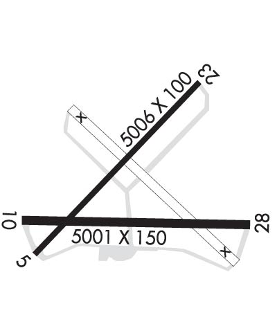
| Lat: N 3159.3 Long: W 08346.4 Elev: 310 Var: +06 Longest Runway: 5008 | ||
| AWOS: 119.32 CTAF: 123.05 | ||
| |||||||||||||||||||||||||||||||||||||||||||||||||||||||||||||
| |||||||||||||||||||||||||||||||||||||||||||||||||||||||||||||
| |||||||||||||||||||||||||||||||||||||||||||||||||||||||||||||
| Rwy | Rwy | |||||||
| 5008x100 | 4882' | 5008x100 | 4868' | |||||
| 5001x150 | 5001' | 108.90 - 103° | 5001x150 | 5001' | ||||
| Runway ID | Single Wheel | Double Wheel | Double Tandem Wheel | Dual Double Wheel |
| 06/24 | 24,000 | N/A | N/A | N/A |
| 10/28 | 30,000 | 45,000 | N/A | N/A |
| These numbers are Advisory and are not limits. The Airport Manager should have more accurate Weight Limits | ||||
 Airport Diagram might not be current. | |
| Facility Name: | CRISP COUNTY-CORDELE |
| City Name: | CORDELE |
| County: | CRISP |
| State abbrev: | GA |
| State Name: | GEORGIA |
| Ownership: | PUBLICLY OWNED |
| Use: | OPEN TO THE PUBLIC |
| Owner's Name: | CRISP COUNTY |
| Address: | 210 7TH ST SOUTH |
| CORDELE, GA 31015 | |
| Owner's Phone: | 229-276-2672 |
| Manager's Name: | SHERRIE LEGER LEVERETT |
| Address: | 210 S 7TH STREET |
| CORDELE, GA 31015 | |
| Phone: | 229-276-2673 |
| FAA Region: | SOUTHERN |
| FAA Field Office: | ATL |
| Date | Sunrise | Sunset |
|---|---|---|
| 02/06/25 Thursday | 7:25 | 18:14 |
| 02/07/25 Friday | 7:25 | 18:14 |
| 02/08/25 Saturday | 7:24 | 18:15 |
| 02/09/25 Sunday | 7:23 | 18:16 |
| 02/10/25 Monday | 7:22 | 18:17 |
| 02/11/25 Tuesday | 7:21 | 18:18 |
| 02/12/25 Wednesday | 7:20 | 18:19 |
| 02/13/25 Thursday | 7:19 | 18:20 |
| 02/14/25 Friday | 7:19 | 18:21 |
| 02/15/25 Saturday | 7:18 | 18:21 |
| 02/16/25 Sunday | 7:17 | 18:22 |
| 02/17/25 Monday | 7:16 | 18:23 |
| 02/18/25 Tuesday | 7:15 | 18:24 |
| 02/19/25 Wednesday | 7:14 | 18:25 |
| Airport Attendance Schedule | NOV-MAR MON-SAT 0800-1700, APR-OCT MON-SAT 0800-1800 |
| Airport Status | OPERATIONAL (This Status can change at any time - please check NOTAMS) |
| Airport Lighting Schedule | MIRL RWY 10/28 & PAPI RWY 10 & 28 PRESET ON LOW INTST DUSK-2200; TO INCR INTST & ACTVT AFT 2200 - CTAF. ACTVT ODALS RWY 10 & REIL RWY 10 & 28 - CTAF. |
| Airport Storage Available | Tie Downs, Hanger |
| Extra Services Available | Crop Dusting, Glider |
| Wind Indicator | YES - (unlit) |
| Control Tower | NO |
| CTAF Frequency | 123.050 |
| Unicom Frequency | 123.050 |
| Rotating Beacon Color | WG |
| Segmented Circle | YES |
| Landing Fee | NO |
| Airport Inspected | STATE - performed by STATE AERONAUTICAL PERSONNEL |
| Inspection Date | 04/11/2024 |
| Type of Fuel Available | Grade 100LL, JET A |
| Airframe Repair Service | MAJOR |
| Power Plant Repair Service | MAJOR |
| Latitude | N3159.3 |
| Longitude | W08346.4 (ESTIMATED) |
| Arpt Elevation | 309ft (SURVEYED) |
| Magnetic Variation | 06W |
| 2 miles NE | of CORDELE |
| Traffic Pattern Altitude | |
| Sectional Chart | JACKSONVILLE |
| Operations (Reported) | Yearly | Avg. Daily |
|---|---|---|
| General Aviation Transient | 0 | 0 |
| General Aviation Local | 0 | 0 |
| Air Taxi | 0 | 0 |
| Commerical | 0 | 0 |
| Commuter | 0 | 0 |
| Military | 0 | 0 |
| Aircraft based on Field | |
|---|---|
| General Aviation Singles | 0 |
| General Aviation Multi | 0 |
| Jet Aircraft | 0 |
| General Aviation Helicopters | 0 |
| Military Aircraft | 0 |
| Gliders | 0 |
| Ultralights | 0 |
| FSS on field | NO |
| FSS tie-in | MACON |
| FSS Phone | 1-800-WX-BRIEF |
| Who issues Notams | MCN |
| Notam D service at airport | YES |
| ARTCC Name | JACKSONVILLE |
| Airport Certification | |
| Aircraft Rescue & Firefighting Index | None |
| Airport of Entry | No |
| Custom Landing Rights | No |
| Joint Civil/Military | No |
| Military Landing rights | YES |
| NATIONAL PLAN OF INTEGRATED AIRPORT SYSTEMS (NPIAS) |
| GRANT AGREEMENTS UNDER FAAP/ADAP/AIP |
| SURPLUS PROPERTY AGREEMENT UNDER REGULATION 16-WAA |
| ASSURANCES PURSUANT TO TITLE VI, CIVIL RIGHTS ACT OF 1964 |
| AGREEMENT UNDER DLAND OR DCLA HAS EXPIRED. |
| FOR CD CTC JACKSONVILLE ARTCC AT 904-845-1592. |
Airport Communications & Frequencies:
| |||||||||
| Runway: 06 | Runway: 24 | ||
| Mag heading: | 56° | Mag heading: | 236° |
| Rwy Slope: | -.06% Down | Rwy Slope: | .06% Up |
| Approach: | Approach: | ||
| Pattern: | Left Traffic | Pattern: | Right Traffic |
| Markings: | NONPRECISION INSTRUMENT | Markings: | NONPRECISION INSTRUMENT |
| Marking Condition: | GOOD | Marking Condition: | GOOD |
| Arresting Dev: | Arresting Dev: | ||
| Lat & Long: | N3159.2 W08346.8 | Lat. & Long.: | N3159.7 W08346.1 |
| Elev: | 309.5 ft. MSL | Elev: | 306.5 ft. MSL |
| TCH: | TCH: | ||
| Visual Glide Path: | Visual Glide Path: | ||
| Displaced Threshold: | 126 feet | Displaced Threshold: | 140 feet |
| Touchdown Zone: | YES | Touchdown Zone: | YES |
| Touchdown Elev.: | 309.0 feet | Touchdown Elev.: | 307.9 feet |
| Visual Glide Slope: | Visual Glide Slope: | ||
| RVR Equipment: | RVR Equipment: | ||
| RVV Equipment: | NO | RVV Equipment: | NO |
| Approach Lights: | Approach Lights: | ||
| REIL: | NO | REIL: | NO |
| Centerline Lights: | NO | Centerline Lights: | NO |
| Touchdown lights: | NO | Touchdown lights: | NO |
| Runway Category: | Runway with a Non-precision Approach having visibility minimums greater than 3/4 mile | Runway Category: | Runway with a Non-precision Approach having visibility minimums greater than 3/4 mile |
| Declared Distances: | Declared Distances: | ||
| Obstructions: | TREE | Obstructions: | TREES |
| Marked: | NOT Marked/Lighted | Marked: | NOT Marked/Lighted |
| Clearance slope: | 10:1 | Clearance slope: | 12:1 |
| Obstruction height: | 27 feet AGL | Obstruction height: | 17 feet AGL |
| Dist. from runway: | 490 feet | Dist. from runway: | 414 feet |
| Centerline offset: | 236 right of centerline | Centerline offset: | 271 feet right of centerline |
| Comments: | Comments: |
| Runway: 10 | Runway: 28 | ||
| Mag heading: | 104° | Mag heading: | 284° |
| Rwy Slope: | .14% Up | Rwy Slope: | -.14% Down |
| Approach: | LOCALIZER | Approach: | |
| Pattern: | Left Traffic | Pattern: | Right Traffic |
| Markings: | NONPRECISION INSTRUMENT | Markings: | NONPRECISION INSTRUMENT |
| Marking Condition: | GOOD | Marking Condition: | GOOD |
| Arresting Dev: | Arresting Dev: | ||
| Lat & Long: | N3159.3 W08346.9 | Lat. & Long.: | N3159.2 W08345.9 |
| Elev: | 301.4 ft. MSL | Elev: | 308.3 ft. MSL |
| TCH: | 42 ft. AGL | TCH: | 45 ft. AGL |
| Visual Glide Path: | 3.00 degrees | Visual Glide Path: | 3.00 degrees |
| Displaced Threshold: | No | Displaced Threshold: | No |
| Touchdown Zone: | YES | Touchdown Zone: | YES |
| Touchdown Elev.: | 307.8 feet | Touchdown Elev.: | 308.5 feet |
| Visual Glide Slope: | 2-Light PAPI on LEFT side of Runway | Visual Glide Slope: | 2-Light PAPI on LEFT side of Runway |
| RVR Equipment: | RVR Equipment: | ||
| RVV Equipment: | NO | RVV Equipment: | NO |
| Approach Lights: | ODALS - omnidirectional approach lighting system | Approach Lights: | |
| REIL: | YES | REIL: | YES |
| Centerline Lights: | NO | Centerline Lights: | NO |
| Touchdown lights: | NO | Touchdown lights: | NO |
| Runway Category: | Runway with a Non-precision Approach having visibility minimums greater than 3/4 mile | Runway Category: | Runway with a Non-precision Approach having visibility minimums greater than 3/4 mile |
| Declared Distances: | Declared Distances: | ||
| Obstructions: | TREES | Obstructions: | TREES |
| Marked: | NOT Marked/Lighted | Marked: | NOT Marked/Lighted |
| Clearance slope: | 23:1 | Clearance slope: | 10:1 |
| Obstruction height: | 92 feet AGL | Obstruction height: | 39 feet AGL |
| Dist. from runway: | 2325 feet | Dist. from runway: | 600 feet |
| Centerline offset: | 438 right of centerline | Centerline offset: | 278 feet left of centerline |
| Comments: | Comments: |
Thanks for using FltPlan.com
all rights reserved © 1999-2025 by Flight Plan LLC

