
| CAPITAL CITY HARRISBURG PA |
| |
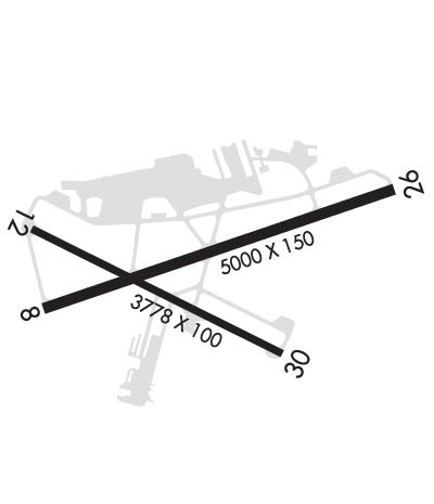
| Lat: N 4013.0 Long: W 07651.1 Elev: 347 Var: +11 Longest Runway: 5000 | ||
| Dept. ATIS: 134.95 Arr. ATIS: 134.95 Ground: 121.9 Tower: 119.5 | ||
| ||||||
| ||||||
|
| Rwy | Rwy | |||||||
| 5000x150 | 5000' | 109.10 - 082° | 5000x150 | 5000' | ||||
| 3778x100 | 3778' | 3778x100 | 3778' | |||||
| Runway ID | Single Wheel | Double Wheel | Double Tandem Wheel | Dual Double Wheel |
| 08/26 | 65,000 | 105,000 | 185,000 | N/A |
| 12/30 | 40,000 | 65,000 | 115,000 | N/A |
| These numbers are Advisory and are not limits. The Airport Manager should have more accurate Weight Limits | ||||
 Airport Diagram might not be current. | |
| Facility Name: | CAPITAL CITY |
| City Name: | HARRISBURG |
| County: | YORK |
| State abbrev: | PA |
| State Name: | PENNSYLVANIA |
| Ownership: | PUBLICLY OWNED |
| Use: | OPEN TO THE PUBLIC |
| Owner's Name: | SUSQUEHANNA REG ARPT AUTH |
| Address: | ONE TERMINAL DRIVE, SUITE 30 |
| MIDDLETOWN, PA 17057 | |
| Owner's Phone: | 717-948-3900 |
| Manager's Name: | TIM EDWARDS |
| Address: | ONE TERMINAL DRIVE, SUITE 30 |
| MIDDLETOWN, PA 17057 | |
| Phone: | 717-774-8335 |
| FAA Region: | EASTERN |
| FAA Field Office: | HAR |
| Date | Sunrise | Sunset |
|---|---|---|
| 09/24/21 Friday | 6:57 | 19:02 |
| 09/25/21 Saturday | 6:58 | 19:00 |
| 09/26/21 Sunday | 6:59 | 18:58 |
| 09/27/21 Monday | 7:00 | 18:57 |
| 09/28/21 Tuesday | 7:01 | 18:55 |
| 09/29/21 Wednesday | 7:01 | 18:53 |
| 09/30/21 Thursday | 7:02 | 18:52 |
| 10/01/21 Friday | 7:03 | 18:50 |
| 10/02/21 Saturday | 7:04 | 18:48 |
| 10/03/21 Sunday | 7:05 | 18:47 |
| 10/04/21 Monday | 7:06 | 18:45 |
| 10/05/21 Tuesday | 7:07 | 18:44 |
| 10/06/21 Wednesday | 7:08 | 18:42 |
| 10/07/21 Thursday | 7:10 | 18:40 |
| Airport Attendance Schedule | 7 Days A Week 0600-2300 |
| Airport Status | OPERATIONAL (This Status can change at any time - please check NOTAMS) |
| Airport Lighting Schedule | WHEN ATCT CLSD ACTVT MALSR RWY 08; HIRL RWY 08/26; MIRL RWY 12/30 & TWY LGTS - CTAF. |
| Airport Storage Available | Tie Downs, Hanger |
| Extra Services Available | Avionics, Charter, Flight Instruction, Aircraft Rental |
| Wind Indicator | YES - (lighted) |
| Control Tower | YES |
| CTAF Frequency | 119.500 |
| Unicom Frequency | 122.950 |
| Rotating Beacon Color | CLEAR-GREEN (Light Land Airport) |
| Segmented Circle | YES |
| Landing Fee | NO |
| Airport Inspected | STATE - performed by STATE AERONAUTICAL PERSONNEL |
| Inspection Date | 01/14/2021 |
| Type of Fuel Available | Grade 100LL, JET A (freeze point -40C) |
| Airframe Repair Service | MAJOR |
| Power Plant Repair Service | MAJOR |
| Latitude | N4013.0 |
| Longitude | W07651.1 (ESTIMATED) |
| Arpt Elevation | 346ft (SURVEYED) |
| Magnetic Variation | 11W |
| 3 miles SE | of HARRISBURG |
| Traffic Pattern Altitude | 1500; HIGH TERRAIN SOUTH RWY 12/30. TPA 1500(1153) CONVENTIONAL. |
| Sectional Chart | NEW YORK |
| Operations (Reported) | Yearly | Avg. Daily |
|---|---|---|
| General Aviation Transient | 17530 | 48 |
| General Aviation Local | 6463 | 18 |
| Air Taxi | 537 | 1 |
| Commerical | 0 | 0 |
| Commuter | 0 | 0 |
| Military | 2818 | 8 |
| Aircraft based on Field | |
|---|---|
| General Aviation Singles | 32 |
| General Aviation Multi | 7 |
| Jet Aircraft | 0 |
| General Aviation Helicopters | 0 |
| Military Aircraft | 4 |
| Gliders | 0 |
| Ultralights | 0 |
| FSS on field | NO |
| FSS tie-in | WILLIAMSPORT |
| FSS Phone | 1-800-WX-BRIEF |
| Who issues Notams | CXY |
| Notam D service at airport | YES |
| ARTCC Name | NEW YORK |
| Airport Certification | |
| Aircraft Rescue & Firefighting Index | None |
| Airport of Entry | No |
| Custom Landing Rights | No |
| Joint Civil/Military | No |
| Military Landing rights | YES |
| NATIONAL PLAN OF INTEGRATED AIRPORT SYSTEMS (NPIAS) |
| GRANT AGREEMENTS UNDER FAAP/ADAP/AIP |
| ASSURANCES PURSUANT TO TITLE VI, CIVIL RIGHTS ACT OF 1964 |
| PPR FOR HAZARDOUS CARGO. |
| ARPT CLSD TO FAR PART 121 ACFT. |
| BIRD FLOCKS ON & INVOF ARPT. |
| ALERT: ACTIVE TXY PRIOR TO RY 12 RELOCATED THLD, NO T/O OR LNDG ON THIS SURFACE. |
| FOR CD WHEN ATCT CLSD CTC HARRISBURG APCH 124.1 OR 800-932-0712. |
| RWY 08/2 6 & RWY 12/30, PPR FOR LOADS OVER 100,000 LBS. |
Airport Communications & Frequencies:
| |||||||||||||||||||||||||||||
| Runway: 08 | Runway: 26 | ||
| Mag heading: | 82° | Mag heading: | 262° |
| Rwy Slope: | .23% Up | Rwy Slope: | -.23% Down |
| Approach: | ILS | Approach: | |
| Pattern: | Left Traffic | Pattern: | Right Traffic |
| Markings: | PRECISION INSTRUMENT | Markings: | NONPRECISION INSTRUMENT |
| Marking Condition: | GOOD | Marking Condition: | GOOD |
| Arresting Dev: | Arresting Dev: | ||
| Lat & Long: | N4012.9 W07651.5 | Lat. & Long.: | N4013.2 W07650.5 |
| Elev: | 334.7 ft. MSL | Elev: | 346.4 ft. MSL |
| TCH: | 55 ft. AGL | TCH: | 56 ft. AGL |
| Visual Glide Path: | 3.00 degrees | Visual Glide Path: | 3.10 degrees |
| Displaced Threshold: | No | Displaced Threshold: | No |
| Touchdown Zone: | YES | Touchdown Zone: | YES |
| Touchdown Elev.: | 342.0 feet | Touchdown Elev.: | 346.7 feet |
| Visual Glide Slope: | 4-Light PAPI on RIGHT side of Runway; RWY 08 PAPI UNUSBL BYD 7 DEGS RIGHT OF CRS. | Visual Glide Slope: | 4-BOX VASI ON LEFT SIDE OF RUNWAY |
| RVR Equipment: | TOUCHDOWN | RVR Equipment: | |
| RVV Equipment: | YES | RVV Equipment: | NO |
| Approach Lights: | MALSR - 1,400 foot medium intensity approach lighting system with runway alignment indicator lights | Approach Lights: | |
| REIL: | NO | REIL: | NO |
| Centerline Lights: | NO | Centerline Lights: | NO |
| Touchdown lights: | NO | Touchdown lights: | NO |
| Runway Category: | Precision Instrument Runway | Runway Category: | Runway with a Non-precision Approach having visibility minimums greater than 3/4 mile |
| Declared Distances: | Declared Distances: | ||
| Obstructions: | POLE | Obstructions: | POLE |
| Marked: | NOT Marked/Lighted | Marked: | LIGHTED |
| Clearance slope: | 16:1 | Clearance slope: | 16:1 |
| Obstruction height: | 21 feet AGL | Obstruction height: | 15 feet AGL |
| Dist. from runway: | 545 feet | Dist. from runway: | 445 feet |
| Centerline offset: | 302 right of centerline | Centerline offset: | 289 feet right of centerline |
| Comments: | Comments: | RWY 26 +7 FT ROAD;GOLF COURSE, +6 FT FENCE EAST AND SOUTH OF RWY END. |
| Runway: 12 | Runway: 30 | ||
| Mag heading: | 128° | Mag heading: | 308° |
| Rwy Slope: | .26% Up | Rwy Slope: | -.26% Down |
| Approach: | Approach: | ||
| Pattern: | Right Traffic | Pattern: | Left Traffic |
| Markings: | NONPRECISION INSTRUMENT | Markings: | NONPRECISION INSTRUMENT |
| Marking Condition: | GOOD | Marking Condition: | GOOD |
| Arresting Dev: | Arresting Dev: | ||
| Lat & Long: | N4013.1 W07651.5 | Lat. & Long.: | N4012.8 W07650.8 |
| Elev: | 333.9 ft. MSL | Elev: | 343.6 ft. MSL |
| TCH: | 49 ft. AGL | TCH: | 56 ft. AGL |
| Visual Glide Path: | 3.90 degrees | Visual Glide Path: | 4.00 degrees |
| Displaced Threshold: | No | Displaced Threshold: | No |
| Touchdown Zone: | YES | Touchdown Zone: | YES |
| Touchdown Elev.: | 341.8 feet | Touchdown Elev.: | 343.6 feet |
| Visual Glide Slope: | 4-BOX VASI ON LEFT SIDE OF RUNWAY | Visual Glide Slope: | 4-BOX VASI ON LEFT SIDE OF RUNWAY |
| RVR Equipment: | RVR Equipment: | ||
| RVV Equipment: | NO | RVV Equipment: | NO |
| Approach Lights: | Approach Lights: | ||
| REIL: | YES | REIL: | YES |
| Centerline Lights: | NO | Centerline Lights: | NO |
| Touchdown lights: | NO | Touchdown lights: | NO |
| Runway Category: | Runway with a Visual Approach | Runway Category: | Runway with a Visual Approach |
| Declared Distances: | Declared Distances: | ||
| Obstructions: | TREE | Obstructions: | TREE |
| Marked: | NOT Marked/Lighted | Marked: | NOT Marked/Lighted |
| Clearance slope: | 5:1 | Clearance slope: | 16:1 |
| Obstruction height: | 55 feet AGL | Obstruction height: | 93 feet AGL |
| Dist. from runway: | 496 feet | Dist. from runway: | 1721 feet |
| Centerline offset: | 180 right of centerline | Centerline offset: | 150 feet right of centerline |
| Comments: | Comments: |
Thanks for using FltPlan.com
all rights reserved © 1999-2021 by Flight Plan LLC
