
| DOUGLAS MUNI DOUGLAS AZ |
| |
| Lat: N 3120.6 Long: W 10930.4 Elev: 4173 Var: -12 Longest Runway: 5760 | ||
| CTAF: 122.8 | ||
| ||||||||||||||||||||||||||||||||||||||||||||
| ||||||||||||||||||||||||||||||||||||||||||||
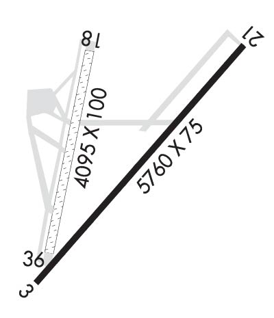
| Rwy | Rwy | |||||||
| 5760x75 | 5760' | 5760x75 | 5760' | |||||
| 4095x100 | 4095' | 4095x100 | 4095' | |||||
| Runway ID | Single Wheel | Double Wheel | Double Tandem Wheel | Dual Double Wheel |
| 03/21 | N/A | N/A | N/A | N/A |
| 18/36 | N/A | N/A | N/A | N/A |
| These numbers are Advisory and are not limits. The Airport Manager should have more accurate Weight Limits | ||||
| FltPlan does not have IFR approach charts available for KDGL. |
 Airport Diagram might not be current. | |
| Facility Name: | DOUGLAS MUNI |
| City Name: | DOUGLAS |
| County: | COCHISE |
| State abbrev: | AZ |
| State Name: | ARIZONA |
| Ownership: | PUBLICLY OWNED |
| Use: | OPEN TO THE PUBLIC |
| Owner's Name: | CITY OF DOUGLAS |
| Address: | 425 10TH STREET |
| DOUGLAS, AZ 85607 | |
| Owner's Phone: | 520-417-7329 |
| Manager's Name: | MAX TAPIA; ALTERNATE ALEXANDRO TERAN, 520--368-6015. |
| Address: | 425 E. 10TH STREET |
| DOUGLAS, AZ 85607 | |
| Phone: | (520) 368-6015 |
| FAA Region: | WESTERN-PACIFIC |
| FAA Field Office: | PHX |
| Date | Sunrise | Sunset |
|---|---|---|
| 04/25/25 Friday | 5:39 | 18:53 |
| 04/26/25 Saturday | 5:38 | 18:54 |
| 04/27/25 Sunday | 5:37 | 18:55 |
| 04/28/25 Monday | 5:36 | 18:55 |
| 04/29/25 Tuesday | 5:35 | 18:56 |
| 04/30/25 Wednesday | 5:34 | 18:57 |
| 05/01/25 Thursday | 5:33 | 18:57 |
| 05/02/25 Friday | 5:32 | 18:58 |
| 05/03/25 Saturday | 5:31 | 18:59 |
| 05/04/25 Sunday | 5:31 | 18:59 |
| 05/05/25 Monday | 5:30 | 19:00 |
| 05/06/25 Tuesday | 5:29 | 19:01 |
| 05/07/25 Wednesday | 5:28 | 19:02 |
| 05/08/25 Thursday | 5:27 | 19:02 |
| Airport Attendance Schedule | MON-FRI 0600-1400; FOR SVC AFT HRS CALL 520-368-6015. |
| Airport Status | OPERATIONAL (This Status can change at any time - please check NOTAMS) |
| Airport Lighting Schedule | DUSK-DAWN. PAPI RWYS 03 AND 21 OTS INDFLY. |
| Airport Storage Available | Tie Downs, Hanger |
| Extra Services Available | Air Ambulance |
| Wind Indicator | YES - (lighted) |
| Control Tower | NO |
| CTAF Frequency | 122.800 |
| Unicom Frequency | 122.800 |
| Rotating Beacon Color | WG |
| Segmented Circle | YES |
| Landing Fee | NO |
| Airport Inspected | STATE - performed by PRIVATE CONTRACT PERSONNEL |
| Inspection Date | 04/11/2023 |
| Type of Fuel Available | Grade 100LL, JET A (freeze point -40C); -1024 HOUR 100LL AVAILABLE WITH MAJOR CREDIT CARD. |
| Airframe Repair Service | None |
| Power Plant Repair Service | None |
| Latitude | N3120.6 |
| Longitude | W10930.4 (ESTIMATED) |
| Arpt Elevation | 4173ft (SURVEYED) |
| Magnetic Variation | 12E |
| 2 miles E | of DOUGLAS |
| Traffic Pattern Altitude | |
| Sectional Chart | PHOENIX |
| Operations (Reported) | Yearly | Avg. Daily |
|---|---|---|
| General Aviation Transient | 0 | 0 |
| General Aviation Local | 0 | 0 |
| Air Taxi | 0 | 0 |
| Commerical | 0 | 0 |
| Commuter | 0 | 0 |
| Military | 0 | 0 |
| Aircraft based on Field | |
|---|---|
| General Aviation Singles | 0 |
| General Aviation Multi | 0 |
| Jet Aircraft | 0 |
| General Aviation Helicopters | 0 |
| Military Aircraft | 0 |
| Gliders | 0 |
| Ultralights | 0 |
| FSS on field | NO |
| FSS tie-in | PRESCOTT |
| FSS Phone | 1-800-WX-BRIEF |
| Who issues Notams | PRC |
| Notam D service at airport | YES |
| ARTCC Name | ALBUQUERQUE |
| Airport Certification | |
| Aircraft Rescue & Firefighting Index | None |
| Airport of Entry | YES |
| Custom Landing Rights | No |
| Joint Civil/Military | No |
| Military Landing rights | No |
| MTNS 1 1/2 MILES EAST. |
| FLIGHT NOTIFICATION SVC AVBL. |
| RWY 18/36 BRUSH ON BOTH SIDES 70 FT FM CNTRLN FULL LENGTH OF RWY. |
| RWY 18/36 +3 FT BUMP 300 FT FROM RWY 18 THLD. |
| RWY 18/36 2 FT BUMP CROSSING TXY TO RWY 03/21. |
| PERSONNEL ON ATVS NEAR AIRCRAFT OPERATING AREAS - UNRESTRICTED. |
| RWY 03/21, 4-6 FT BRUSH IN PRIMARY SURFACE AS CLOSE AS 30 FT FM CNTRLN. |
| RWY 18/3 6 RY CLSD INDEFLY. |
| RWY 03/2 1 RY HAS 1-6 INCH CRACKS ACROSS RY. |
| RWY 18/3 6 RY HAS +4 FT BRUSH, ROCKS & UNEVEN SURFACE FOR 3/4 OF RY LENGTH. |
Airport Communications & Frequencies:
| |||||||||
| Runway: 03 | Runway: 21 | ||
| Mag heading: | N/A | Mag heading: | N/A |
| Approach: | Approach: | ||
| Pattern: | Right Traffic | Pattern: | Left Traffic |
| Markings: | BASIC | Markings: | BASIC |
| Marking Condition: | GOOD | Marking Condition: | GOOD |
| Arresting Dev: | Arresting Dev: | ||
| Lat & Long: | N3120.2 W10930.6 | Lat. & Long.: | N3120.9 W10929.9 |
| Elev: | N/A | Elev: | N/A |
| TCH: | 40 ft. AGL | TCH: | 50 ft. AGL |
| Visual Glide Path: | 4.00 degrees | Visual Glide Path: | 4.00 degrees |
| Displaced Threshold: | No | Displaced Threshold: | No |
| Touchdown Zone: | NO | Touchdown Zone: | NO |
| Touchdown Elev.: | Touchdown Elev.: | ||
| Visual Glide Slope: | 4-Light PAPI on LEFT side of Runway; PAPI OTS INDEFLY. | Visual Glide Slope: | 4-Light PAPI on LEFT side of Runway; PAPI OTS INDEF. |
| RVR Equipment: | RVR Equipment: | ||
| RVV Equipment: | NO | RVV Equipment: | NO |
| Approach Lights: | Approach Lights: | ||
| REIL: | NO | REIL: | NO |
| Centerline Lights: | NO | Centerline Lights: | NO |
| Touchdown lights: | NO | Touchdown lights: | NO |
| Runway Category: | Runway with a Visual Approach | Runway Category: | Runway with a Visual Approach |
| Declared Distances: | Declared Distances: | ||
| Obstructions: | BRUSH | Obstructions: | BRUSH; 50 FT TWR 1350 FT FM THLD 550 FT LEFT LGTD. |
| Marked: | NOT Marked/Lighted | Marked: | NOT Marked/Lighted |
| Clearance slope: | 8:1 | Clearance slope: | |
| Obstruction height: | 7 feet AGL | Obstruction height: | 8 feet AGL |
| Dist. from runway: | 260 feet | Dist. from runway: | 201 feet |
| Centerline offset: | 10 right of centerline | Centerline offset: | 45 feet right of centerline |
| Comments: | RWY 03, 3-8 FT BRUSH 0-200 FT FM THR, 45-125 FT LEFT AND RIGHT OF CNTRLN. | Comments: | RWY 21, 2-6 FT BRUSH 0-200 FT FM THR, 30-125 FT LEFT AND RIGHT OF CNTRLN. |
| Runway: 18 | Runway: 36 | ||
| Mag heading: | N/A | Mag heading: | N/A |
| Approach: | Approach: | ||
| Pattern: | Left Traffic | Pattern: | Right Traffic |
| Markings: | Markings: | ||
| Marking Condition: | Marking Condition: | ||
| Arresting Dev: | Arresting Dev: | ||
| Lat & Long: | Lat. & Long.: | ||
| Elev: | N/A | Elev: | N/A |
| TCH: | TCH: | ||
| Visual Glide Path: | Visual Glide Path: | ||
| Displaced Threshold: | No | Displaced Threshold: | No |
| Touchdown Zone: | NO | Touchdown Zone: | NO |
| Touchdown Elev.: | Touchdown Elev.: | ||
| Visual Glide Slope: | Visual Glide Slope: | ||
| RVR Equipment: | RVR Equipment: | ||
| RVV Equipment: | NO | RVV Equipment: | NO |
| Approach Lights: | Approach Lights: | ||
| REIL: | NO | REIL: | NO |
| Centerline Lights: | NO | Centerline Lights: | NO |
| Touchdown lights: | NO | Touchdown lights: | NO |
| Runway Category: | Runway with a Visual Approach | Runway Category: | Runway with a Visual Approach |
| Declared Distances: | Declared Distances: | ||
| Obstructions: | BRUSH | Obstructions: | BRUSH |
| Marked: | NOT Marked/Lighted | Marked: | NOT Marked/Lighted |
| Clearance slope: | Clearance slope: | ||
| Obstruction height: | 6 feet AGL | Obstruction height: | 6 feet AGL |
| Dist. from runway: | 0 feet | Dist. from runway: | 0 feet |
| Centerline offset: | Centerline offset: | ||
| Comments: | Comments: |
Thanks for using FltPlan.com
all rights reserved © 1999-2025 by Flight Plan LLC
