
| DRUMMOND ISLAND DRUMMOND ISLAND MI |
| |
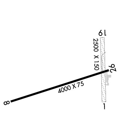
| Lat: N 4600.6 Long: W 08344.6 Elev: 668 Var: +07 Longest Runway: 4000 | ||
| AWOS: 118.32 CTAF: 122.8 | ||
| ||||||
| ||||||
|
| Rwy | Rwy | |||||||
| 2500x150 | 2500' | 2500x150 | 2500' | |||||
| 4000x75 | 3350' | 4000x75 | 3830' | |||||
| Runway ID | Single Wheel | Double Wheel | Double Tandem Wheel | Dual Double Wheel |
| 01/19 | N/A | N/A | N/A | N/A |
| 08/26 | N/A | N/A | N/A | N/A |
| These numbers are Advisory and are not limits. The Airport Manager should have more accurate Weight Limits | ||||
 Airport Diagram might not be current. | |
| Facility Name: | DRUMMOND ISLAND |
| City Name: | DRUMMOND ISLAND |
| County: | CHIPPEWA |
| State abbrev: | MI |
| State Name: | MICHIGAN |
| Ownership: | PUBLICLY OWNED |
| Use: | OPEN TO THE PUBLIC |
| Owner's Name: | DRUMMOND TOWNSHIP |
| Address: | P.O.BOX 245 |
| DRUMMOND ISLAND, MI 49726 | |
| Owner's Phone: | 906-493-5321 |
| Manager's Name: | JAMES BAILEY |
| Address: | 34264 S. TOWNLINE RD. |
| DRUMMOND ISLAND, MI 49726 | |
| Phone: | 906-493-5411 |
| FAA Region: | GREAT LAKES |
| FAA Field Office: | DET |
| Date | Sunrise | Sunset |
|---|---|---|
| 09/24/21 Friday | 7:24 | 19:29 |
| 09/25/21 Saturday | 7:25 | 19:27 |
| 09/26/21 Sunday | 7:27 | 19:25 |
| 09/27/21 Monday | 7:28 | 19:23 |
| 09/28/21 Tuesday | 7:29 | 19:21 |
| 09/29/21 Wednesday | 7:30 | 19:19 |
| 09/30/21 Thursday | 7:32 | 19:17 |
| 10/01/21 Friday | 7:33 | 19:15 |
| 10/02/21 Saturday | 7:34 | 19:14 |
| 10/03/21 Sunday | 7:36 | 19:12 |
| 10/04/21 Monday | 7:37 | 19:10 |
| 10/05/21 Tuesday | 7:38 | 19:08 |
| 10/06/21 Wednesday | 7:40 | 19:06 |
| 10/07/21 Thursday | 7:41 | 19:04 |
| Airport Attendance Schedule | MON-SAT 0800-1700 |
| Airport Status | OPERATIONAL (This Status can change at any time - please check NOTAMS) |
| Airport Lighting Schedule | ACTVT MIRL RY 08/26 & PAPI RYS 08 & 26 - CTAF. |
| Airport Storage Available | Tie Downs |
| Extra Services Available | Charter |
| Wind Indicator | YES - (lighted) |
| Control Tower | NO |
| CTAF Frequency | 122.800 |
| Unicom Frequency | 122.800 |
| Rotating Beacon Color | CLEAR-GREEN (Light Land Airport) |
| Segmented Circle | YES |
| Landing Fee | NO |
| Airport Inspected | STATE - performed by STATE AERONAUTICAL PERSONNEL |
| Inspection Date | 07/26/2019 |
| Type of Fuel Available | Grade 100LLMOGAS |
| Airframe Repair Service | MAJOR |
| Power Plant Repair Service | MAJOR |
| Latitude | N4600.6 |
| Longitude | W08344.6 (ESTIMATED) |
| Arpt Elevation | 668ft (SURVEYED) |
| Magnetic Variation | 07W |
| 1 miles SW | of DRUMMOND ISLAND |
| Traffic Pattern Altitude | 1000 |
| Sectional Chart | LAKE HURON |
| Operations (Reported) | Yearly | Avg. Daily |
|---|---|---|
| General Aviation Transient | 2500 | 7 |
| General Aviation Local | 2500 | 7 |
| Air Taxi | 0 | 0 |
| Commerical | 0 | 0 |
| Commuter | 0 | 0 |
| Military | 0 | 0 |
| Aircraft based on Field | |
|---|---|
| General Aviation Singles | 6 |
| General Aviation Multi | 0 |
| Jet Aircraft | 0 |
| General Aviation Helicopters | 0 |
| Military Aircraft | 0 |
| Gliders | 0 |
| Ultralights | 0 |
| FSS on field | NO |
| FSS tie-in | GREEN BAY |
| FSS Phone | 1-800-WX-BRIEF |
| Who issues Notams | DRM |
| Notam D service at airport | YES |
| ARTCC Name | MINNEAPOLIS |
| Airport Certification | |
| Aircraft Rescue & Firefighting Index | None |
| Airport of Entry | No |
| Custom Landing Rights | YES |
| Joint Civil/Military | No |
| Military Landing rights | No |
| NATIONAL PLAN OF INTEGRATED AIRPORT SYSTEMS (NPIAS) |
| THIS AIRPORT HAS BEEN SURVEYED BY THE NATIONAL GEODETIC SURVEY. |
| OCNL GOLF CARTS & PEDESTRIANS CROSSING RY 08/26 DUE TO GOLF COURSE ON BOTH SIDES. |
| FLIGHT NOTIFICATION SVC (ADCUS) AVBL. |
| BIRDS & DEER ON & INVOF ARPT. |
| DRUMMOND ISL., YACHT HAVEN SEA PLANE BASE LCTD 1.5 MI N., CUSTOMS AVBL 906-632-8822, 906-632-7221. |
| FOR CD CTC MINNEAPOLIS ARTCC AT 651-463-5588. |
| RWY 01/1 9 RY 01/19 CENTER 20 FT OF RY FM INTXN RY 08/26 N TO THE HANGAR LINE IS ASPH; REMAINDER OF RY TURF. |
Airport Communications & Frequencies:
| |||||||||
| Runway: 01 | Runway: 19 | ||
| Mag heading: | 6° | Mag heading: | 186° |
| Approach: | Approach: | ||
| Pattern: | Left Traffic | Pattern: | Left Traffic |
| Markings: | Markings: | ||
| Marking Condition: | Marking Condition: | RY 01/19 MKD WITH 3 FT YELLOW CONES. | |
| Arresting Dev: | Arresting Dev: | ||
| Lat & Long: | N4600.4 W08344.4 | Lat. & Long.: | N4600.8 W08344.4 |
| Elev: | N/A | Elev: | N/A |
| TCH: | TCH: | ||
| Visual Glide Path: | Visual Glide Path: | ||
| Displaced Threshold: | No | Displaced Threshold: | No |
| Touchdown Zone: | NO | Touchdown Zone: | NO |
| Touchdown Elev.: | Touchdown Elev.: | ||
| Visual Glide Slope: | Visual Glide Slope: | ||
| RVR Equipment: | RVR Equipment: | ||
| RVV Equipment: | NO | RVV Equipment: | NO |
| Approach Lights: | Approach Lights: | ||
| REIL: | NO | REIL: | NO |
| Centerline Lights: | NO | Centerline Lights: | NO |
| Touchdown lights: | NO | Touchdown lights: | NO |
| Runway Category: | Runway with a Visual Approach | Runway Category: | Runway with a Visual Approach |
| Declared Distances: | Declared Distances: | ||
| Obstructions: | TREES; RWY 19 +55 FT TREES 1100 FT DSTC 20:1; ALSO +36 FT TREES; 105 R; 180 FT DSTC; 5:1. | Obstructions: | TREES |
| Marked: | NOT Marked/Lighted | Marked: | NOT Marked/Lighted |
| Clearance slope: | Clearance slope: | RY 19 APCH RATIO 20 :1 BASED ON STRAIGHT OUT OVR 63 FT TREES, 1260 FT DSTC. | |
| Obstruction height: | 40 feet AGL | Obstruction height: | 50 feet AGL |
| Dist. from runway: | 0 feet | Dist. from runway: | 0 feet |
| Centerline offset: | 115B | Centerline offset: | 75 feet right of centerline |
| Comments: | Comments: |
| Runway: 08 | Runway: 26 | ||
| Mag heading: | 79° | Mag heading: | 259° |
| Rwy Slope: | -.05% Down | Rwy Slope: | .05% Up |
| Approach: | Approach: | ||
| Pattern: | Left Traffic | Pattern: | Left Traffic |
| Markings: | NONPRECISION INSTRUMENT | Markings: | NONPRECISION INSTRUMENT |
| Marking Condition: | GOOD | Marking Condition: | GOOD |
| Arresting Dev: | Arresting Dev: | ||
| Lat & Long: | N4600.4 W08345.2 | Lat. & Long.: | N4600.6 W08344.3 |
| Elev: | 659.4 ft. MSL | Elev: | 657.4 ft. MSL |
| TCH: | 35 ft. AGL | TCH: | 25 ft. AGL |
| Visual Glide Path: | 3.00 degrees | Visual Glide Path: | 3.00 degrees |
| Displaced Threshold: | 650 feet | Displaced Threshold: | 170 feet |
| Touchdown Zone: | YES | Touchdown Zone: | YES |
| Touchdown Elev.: | 660.7 feet | Touchdown Elev.: | 660.7 feet |
| Visual Glide Slope: | 2-Light PAPI on LEFT side of Runway | Visual Glide Slope: | 2-Light PAPI on LEFT side of Runway |
| RVR Equipment: | RVR Equipment: | ||
| RVV Equipment: | NO | RVV Equipment: | NO |
| Approach Lights: | Approach Lights: | ||
| REIL: | NO | REIL: | NO |
| Centerline Lights: | NO | Centerline Lights: | NO |
| Touchdown lights: | NO | Touchdown lights: | NO |
| Runway Category: | Runway with a Non-precision Approach | Runway Category: | Runway with a Non-precision Approach |
| Declared Distances: | Declared Distances: | ||
| Obstructions: | TREES | Obstructions: | ROAD |
| Marked: | NOT Marked/Lighted | Marked: | NOT Marked/Lighted |
| Clearance slope: | Clearance slope: | ||
| Obstruction height: | 30 feet AGL | Obstruction height: | 15 feet AGL |
| Dist. from runway: | 201 feet | Dist. from runway: | 201 feet |
| Centerline offset: | 175 left of centerline | Centerline offset: | 125B |
| Comments: | +4 FT FENCE 20 FT DSTC; +10 FT HILL 10 FT DSTC 50 FT L; +18 FT BLDG 97 FT DSTC 50 FT R; +50 FT TREES 20 FT DSTC, 90 FT R/L. | Comments: | +6 FT FENCE 54 FT DSTC; +15 FT ROAD 112 FT DSTC; +20 FT BLDG, 0 FT DSTC, 200 FT R. |
Thanks for using FltPlan.com
all rights reserved © 1999-2021 by Flight Plan LLC
