
| NEWPORT STATE NEWPORT VT |
| |
| Lat: N 4453.3 Long: W 07213.7 Elev: 934 Var: +17 Longest Runway: 5301 | ||
| Clr Del: 135.7 AWOS: 118.27 CTAF: 122.8 | ||
| ||||||
| ||||||
|
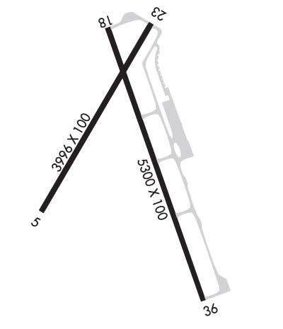
| Rwy | Rwy | |||||||
| 3996x100 | 3996' | 3996x100 | 3996' | |||||
| 5301x100 | 5002' | 5301x100 | 5301' | |||||
| Runway ID | Single Wheel | Double Wheel | Double Tandem Wheel | Dual Double Wheel |
| 05/23 | 30,000 | 44,000 | N/A | N/A |
| 18/36 | 30,000 | 44,000 | N/A | N/A |
| These numbers are Advisory and are not limits. The Airport Manager should have more accurate Weight Limits | ||||
 Airport Diagram might not be current. | |
| Facility Name: | NORTHEAST KINGDOM INTL |
| City Name: | NEWPORT |
| County: | ORLEANS |
| State abbrev: | VT |
| State Name: | VERMONT |
| Ownership: | PUBLICLY OWNED |
| Use: | OPEN TO THE PUBLIC |
| Owner's Name: | STATE OF VERMONT |
| Address: | 219 NORTH MAIN STREET |
| BARRE, VT 05641-5001 | |
| Owner's Phone: | (802) 476-2690 |
| Manager's Name: | DAN GAUVIN |
| Address: | LAKEVIEW AVIATION, 2628 AIRPORT RD-COVENTRY |
| NEWPORT, VT 05855 | |
| Phone: | 802-334-5001 |
| FAA Region: | NEW ENGLAND |
| FAA Field Office: | NONE |
| Date | Sunrise | Sunset |
|---|---|---|
| 09/24/21 Friday | 6:38 | 18:43 |
| 09/25/21 Saturday | 6:39 | 18:41 |
| 09/26/21 Sunday | 6:40 | 18:39 |
| 09/27/21 Monday | 6:42 | 18:37 |
| 09/28/21 Tuesday | 6:43 | 18:36 |
| 09/29/21 Wednesday | 6:44 | 18:34 |
| 09/30/21 Thursday | 6:45 | 18:32 |
| 10/01/21 Friday | 6:47 | 18:30 |
| 10/02/21 Saturday | 6:48 | 18:28 |
| 10/03/21 Sunday | 6:49 | 18:26 |
| 10/04/21 Monday | 6:50 | 18:24 |
| 10/05/21 Tuesday | 6:51 | 18:22 |
| 10/06/21 Wednesday | 6:53 | 18:21 |
| 10/07/21 Thursday | 6:54 | 18:19 |
| Airport Attendance Schedule | 7 Days A Week 0900-1700 |
| Airport Status | OPERATIONAL (This Status can change at any time - please check NOTAMS) |
| Airport Lighting Schedule | ACTVT PAPI RWY 18 & 36; MIRL RWY 18/36 - CTAF. |
| Airport Storage Available | Tie Downs, Hanger |
| Extra Services Available | Flight Instruction, Aircraft Rental |
| Wind Indicator | YES - (lighted) |
| Control Tower | NO |
| CTAF Frequency | 122.800 |
| Unicom Frequency | 122.800 |
| Rotating Beacon Color | CLEAR-GREEN (Light Land Airport) |
| Segmented Circle | YES |
| Landing Fee | NO |
| Airport Inspected | STATE - performed by STATE AERONAUTICAL PERSONNEL |
| Inspection Date | 07/25/2019 |
| Type of Fuel Available | Grade 100LL, JET A; -1024/7 SELF SERVE. MOBILE FUEL VEHICLE WHEN ATNDD.; -A+24/7 SELF SERVE. MOBILE FUEL VEHICLE WHEN ATNDD. |
| Airframe Repair Service | MAJOR |
| Power Plant Repair Service | MAJOR |
| Latitude | N4453.3 |
| Longitude | W07213.7 (ESTIMATED) |
| Arpt Elevation | 933ft (SURVEYED) |
| Magnetic Variation | 17W |
| 3 miles SW | of NEWPORT |
| Traffic Pattern Altitude | |
| Sectional Chart | MONTREAL |
| Operations (Reported) | Yearly | Avg. Daily |
|---|---|---|
| General Aviation Transient | 2000 | 5 |
| General Aviation Local | 6500 | 18 |
| Air Taxi | 500 | 1 |
| Commerical | 0 | 0 |
| Commuter | 0 | 0 |
| Military | 240 | 1 |
| Aircraft based on Field | |
|---|---|
| General Aviation Singles | 17 |
| General Aviation Multi | 1 |
| Jet Aircraft | 0 |
| General Aviation Helicopters | 0 |
| Military Aircraft | 0 |
| Gliders | 2 |
| Ultralights | 0 |
| FSS on field | NO |
| FSS tie-in | BURLINGTON |
| FSS Phone | 1-800-WX-BRIEF |
| Who issues Notams | BTV |
| Notam D service at airport | YES |
| ARTCC Name | BOSTON |
| Airport Certification | |
| Aircraft Rescue & Firefighting Index | None |
| Airport of Entry | No |
| Custom Landing Rights | YES |
| Joint Civil/Military | No |
| Military Landing rights | YES |
| NATIONAL PLAN OF INTEGRATED AIRPORT SYSTEMS (NPIAS) |
| GRANT AGREEMENTS UNDER FAAP/ADAP/AIP |
| ASSURANCES PURSUANT TO TITLE VI, CIVIL RIGHTS ACT OF 1964 |
| AGREEMENT UNDER DLAND OR DCLA HAS EXPIRED. |
| GULLS ON & INVOF ARPT. |
| RWY CONDS MAY NOT BE MNT OR RPRTD WHEN ARPT IS UNATNDD. |
| COLD TEMPERATURE RESTRICTED AIRPORT. ALTITUDE CORRECTION REQUIRED AT OR BELOW -32C. |
Airport Communications & Frequencies:
| |||||||||
| Runway: 05 | Runway: 23 | ||
| Mag heading: | 47° | Mag heading: | 227° |
| Rwy Slope: | .08% Up | Rwy Slope: | -.08% Down |
| Approach: | Approach: | ||
| Pattern: | Left Traffic | Pattern: | Left Traffic |
| Markings: | BASIC | Markings: | BASIC |
| Marking Condition: | FAIR | Marking Condition: | FAIR |
| Arresting Dev: | Arresting Dev: | ||
| Lat & Long: | N4453.1 W07214.1 | Lat. & Long.: | N4453.7 W07213.6 |
| Elev: | 923.1 ft. MSL | Elev: | 926.1 ft. MSL |
| TCH: | TCH: | ||
| Visual Glide Path: | Visual Glide Path: | ||
| Displaced Threshold: | No | Displaced Threshold: | No |
| Touchdown Zone: | YES | Touchdown Zone: | YES |
| Touchdown Elev.: | 928.5 feet | Touchdown Elev.: | 928.6 feet |
| Visual Glide Slope: | Visual Glide Slope: | ||
| RVR Equipment: | RVR Equipment: | ||
| RVV Equipment: | NO | RVV Equipment: | NO |
| Approach Lights: | Approach Lights: | ||
| REIL: | NO | REIL: | NO |
| Centerline Lights: | NO | Centerline Lights: | NO |
| Touchdown lights: | NO | Touchdown lights: | NO |
| Runway Category: | Runway with a Visual Approach | Runway Category: | Runway with a Visual Approach |
| Declared Distances: | Declared Distances: | ||
| Obstructions: | TREES | Obstructions: | POLE |
| Marked: | NOT Marked/Lighted | Marked: | LIGHTED |
| Clearance slope: | 8:1 | Clearance slope: | 20:1 |
| Obstruction height: | 43 feet AGL | Obstruction height: | 32 feet AGL |
| Dist. from runway: | 578 feet | Dist. from runway: | 865 feet |
| Centerline offset: | 80 left of centerline | Centerline offset: | 93 feet left of centerline |
| Comments: | Comments: |
| Runway: 18 | Runway: 36 | ||
| Mag heading: | 177° | Mag heading: | 357° |
| Rwy Slope: | .07% Up | Rwy Slope: | -.07% Down |
| Approach: | Approach: | ||
| Pattern: | Left Traffic | Pattern: | Left Traffic |
| Markings: | NONPRECISION INSTRUMENT | Markings: | NONPRECISION INSTRUMENT |
| Marking Condition: | GOOD | Marking Condition: | GOOD |
| Arresting Dev: | Arresting Dev: | ||
| Lat & Long: | N4453.6 W07213.8 | Lat. & Long.: | N4452.8 W07213.4 |
| Elev: | 930.2 ft. MSL | Elev: | 933.9 ft. MSL |
| TCH: | 43 ft. AGL | TCH: | 44 ft. AGL |
| Visual Glide Path: | 3.00 degrees | Visual Glide Path: | 3.00 degrees |
| Displaced Threshold: | 299 feet | Displaced Threshold: | No |
| Touchdown Zone: | YES | Touchdown Zone: | YES |
| Touchdown Elev.: | 930.4 feet | Touchdown Elev.: | 933.9 feet |
| Visual Glide Slope: | 4-Light PAPI on LEFT side of Runway | Visual Glide Slope: | 4-Light PAPI on LEFT side of Runway |
| RVR Equipment: | RVR Equipment: | ||
| RVV Equipment: | NO | RVV Equipment: | NO |
| Approach Lights: | Approach Lights: | ||
| REIL: | YES | REIL: | YES |
| Centerline Lights: | NO | Centerline Lights: | NO |
| Touchdown lights: | NO | Touchdown lights: | NO |
| Runway Category: | Runway with a Visual Approach | Runway Category: | Runway with a Non-precision Approach |
| Declared Distances: | Declared Distances: | ||
| Obstructions: | Obstructions: | POLE | |
| Marked: | Marked: | LIGHTED | |
| Clearance slope: | 20:1 | Clearance slope: | 25:1 |
| Obstruction height: | Obstruction height: | 71 feet AGL | |
| Dist. from runway: | Dist. from runway: | 2002 feet | |
| Centerline offset: | Centerline offset: | 126 feet right of centerline | |
| Comments: | Comments: |
Thanks for using FltPlan.com
all rights reserved © 1999-2021 by Flight Plan LLC
