| EL MONTE EL MONTE CA |
| |
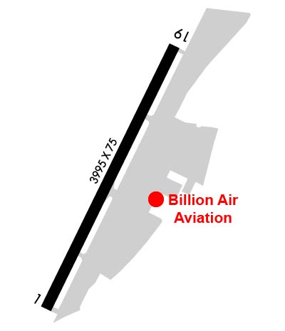
| Lat: N 3405.2 Long: W 11802.1 Elev: 296 Var: -14 Longest Runway: 3995 | ||
| Dept. ATIS: 118.75 Arr. ATIS: 118.75 AWOS: 118.75 Ground: 125.9 Tower: 121.2 | ||
| |||||||||||||||||||||||||||||||||||||||||||||||||||||||||||||||||||||
| |||||||||||||||||||||||||||||||||||||||||||||||||||||||||||||||||||||
| |||||||||||||||||||||||||||||||||||||||||||||||||||||||||||||||||||||
| |||||||||||||||||||||||||||||||||||||||||||||||||||||||||||||||||||||
| Rwy | Rwy | |||||||
| 3995x75 | 3705' | 3995x75 | 3354' | |||||
| Runway ID | Single Wheel | Double Wheel | Double Tandem Wheel | Dual Double Wheel |
| 01/19 | 12,500 | N/A | N/A | N/A |
| These numbers are Advisory and are not limits. The Airport Manager should have more accurate Weight Limits | ||||
 Airport Diagram might not be current. | |
| Facility Name: | SAN GABRIEL VALLEY |
| City Name: | EL MONTE |
| County: | LOS ANGELES |
| State abbrev: | CA |
| State Name: | CALIFORNIA |
| Ownership: | PUBLICLY OWNED |
| Use: | OPEN TO THE PUBLIC |
| Owner's Name: | CO OF LOS ANGELES |
| Address: | P O BOX 1460 |
| ALHAMBRA, CA 91803-1331 | |
| Owner's Phone: | (626) 300-4602; LA COUNTY CTC: RICHARD SMITH (626) 300-4600 X4615. AIRPORT MGT CONTRACTED TO - AMERICAN AIRPORTS CORP. |
| Manager's Name: | ENRIQUE CURIOSO |
| Address: | 4233 NORTH SANTA ANITA AVE |
| EL MONTE, CA 91731 | |
| Phone: | 626-448-6129 |
| FAA Region: | WESTERN-PACIFIC |
| FAA Field Office: | LAX |
| Date | Sunrise | Sunset |
|---|---|---|
| 09/24/21 Friday | 6:41 | 18:46 |
| 09/25/21 Saturday | 6:42 | 18:45 |
| 09/26/21 Sunday | 6:43 | 18:43 |
| 09/27/21 Monday | 6:44 | 18:42 |
| 09/28/21 Tuesday | 6:44 | 18:41 |
| 09/29/21 Wednesday | 6:45 | 18:39 |
| 09/30/21 Thursday | 6:46 | 18:38 |
| 10/01/21 Friday | 6:47 | 18:37 |
| 10/02/21 Saturday | 6:47 | 18:35 |
| 10/03/21 Sunday | 6:48 | 18:34 |
| 10/04/21 Monday | 6:49 | 18:32 |
| 10/05/21 Tuesday | 6:49 | 18:31 |
| 10/06/21 Wednesday | 6:50 | 18:30 |
| 10/07/21 Thursday | 6:51 | 18:28 |
| Airport Attendance Schedule | CONTINUOUS |
| Airport Status | OPERATIONAL (This Status can change at any time - please check NOTAMS) |
| Airport Lighting Schedule | WHEN ATCT CLSD ACTVT MIRL RY 01/19, REIL RY 19, PAPI RYS 01 AND 19 - CTAF. |
| Airport Storage Available | Tie Downs |
| Extra Services Available | Avionics, Charter, Flight Instruction, Aircraft Rental, Aircraft Sales, Annual Surveying |
| Wind Indicator | YES - (lighted) |
| Control Tower | YES |
| CTAF Frequency | 121.200 |
| Unicom Frequency | 122.950 |
| Rotating Beacon Color | CLEAR-GREEN (Light Land Airport) |
| Segmented Circle | YES |
| Landing Fee | NO |
| Airport Inspected | STATE - performed by STATE AERONAUTICAL PERSONNEL |
| Inspection Date | 03/12/2019 |
| Type of Fuel Available | Grade 100LL, JET A (freeze point -40C) |
| Airframe Repair Service | MAJOR |
| Power Plant Repair Service | MAJOR |
| Latitude | N3405.2 |
| Longitude | W11802.1 (ESTIMATED) |
| Arpt Elevation | 295ft (SURVEYED) |
| Magnetic Variation | 14E |
| 1 miles N | of EL MONTE |
| Traffic Pattern Altitude | |
| Sectional Chart | LOS ANGELES |
| Operations (Reported) | Yearly | Avg. Daily |
|---|---|---|
| General Aviation Transient | 37124 | 102 |
| General Aviation Local | 51421 | 141 |
| Air Taxi | 734 | 2 |
| Commerical | 0 | 0 |
| Commuter | 0 | 0 |
| Military | 28 | 0 |
| Aircraft based on Field | |
|---|---|
| General Aviation Singles | 96 |
| General Aviation Multi | 3 |
| Jet Aircraft | 0 |
| General Aviation Helicopters | 5 |
| Military Aircraft | 0 |
| Gliders | 0 |
| Ultralights | 0 |
| FSS on field | NO |
| FSS tie-in | RIVERSIDE |
| FSS Phone | 1-800-WX-BRIEF |
| Who issues Notams | EMT |
| Notam D service at airport | YES |
| ARTCC Name | LOS ANGELES |
| Airport Certification | |
| Aircraft Rescue & Firefighting Index | None |
| Airport of Entry | No |
| Custom Landing Rights | No |
| Joint Civil/Military | No |
| Military Landing rights | YES |
| NATIONAL PLAN OF INTEGRATED AIRPORT SYSTEMS (NPIAS) |
| GRANT AGREEMENTS UNDER FAAP/ADAP/AIP |
| ASSURANCES PURSUANT TO TITLE VI, CIVIL RIGHTS ACT OF 1964 |
| THIS AIRPORT HAS BEEN SURVEYED BY THE NATIONAL GEODETIC SURVEY. |
| REMAIN OVER PAVED CHANNEL ON CLIMB OUT TO SOUTH AND TO NORTH. |
| HEAVY BIRD ACTIVITY ON & INVOF ARPT. |
| LGTD WATER TWR 1 MI W-SW OF ARPT. |
| (E81) CNTR TWY LGTS ONLY. |
| NOISE ABATEMENT PROCEDURES IN EFFECT, CTC ARPT MANAGER FOR DETAILS. |
| FOR CLNC DEL WHEN ATCT CLSD CALL SOCAL APP (800) 448-3724. |
Airport Communications & Frequencies:
| |||||||||||||||||||||||||||||||||||||||||||
| Runway: 01 | Runway: 19 | ||
| Mag heading: | 11° | Mag heading: | 191° |
| Rwy Slope: | .35% Up | Rwy Slope: | -.35% Down |
| Approach: | Approach: | ||
| Pattern: | Left Traffic | Pattern: | Right Traffic |
| Markings: | BASIC | Markings: | BASIC |
| Marking Condition: | GOOD | Marking Condition: | GOOD |
| Arresting Dev: | Arresting Dev: | ||
| Lat & Long: | N3404.9 W11802.3 | Lat. & Long.: | N3405.5 W11801.9 |
| Elev: | 281.8 ft. MSL | Elev: | 295.6 ft. MSL |
| TCH: | 70 ft. AGL | TCH: | 37 ft. AGL |
| Visual Glide Path: | 4.57 degrees | Visual Glide Path: | 4.50 degrees |
| Displaced Threshold: | 290 feet | Displaced Threshold: | 641 feet |
| Touchdown Zone: | YES | Touchdown Zone: | YES |
| Touchdown Elev.: | 293.3 feet | Touchdown Elev.: | 293.5 feet |
| Visual Glide Slope: | 2-Light PAPI on LEFT side of Runway | Visual Glide Slope: | 2-Light PAPI on RIGHT side of Runway |
| RVR Equipment: | RVR Equipment: | ||
| RVV Equipment: | NO | RVV Equipment: | NO |
| Approach Lights: | Approach Lights: | ||
| REIL: | NO | REIL: | YES |
| Centerline Lights: | NO | Centerline Lights: | NO |
| Touchdown lights: | NO | Touchdown lights: | NO |
| Runway Category: | Runway with a Visual Approach | Runway Category: | Runway with a Visual Approach |
| Declared Distances: | TORA:3504' TODA:3995' ASDA:3755' LDA:3465' | Declared Distances: | TORA:3995' TODA:3995' ASDA:3995' LDA:3354' |
| Obstructions: | POLE | Obstructions: | POLE |
| Marked: | NOT Marked/Lighted | Marked: | NOT Marked/Lighted |
| Clearance slope: | 8:1; APCH RATIO 35:1 TO DSPLCD THR; APCH RATIO 33:1 TO DSPLCD THR OVER +45' PLINE OB 1490' FM DSPLCD THR. | Clearance slope: | 20:1; APCH RATIO 48:1 TO DSPLCD THR. |
| Obstruction height: | 18 feet AGL | Obstruction height: | 30 feet AGL |
| Dist. from runway: | 350 feet | Dist. from runway: | 800 feet |
| Centerline offset: | 85 right of centerline | Centerline offset: | 205 feet left of centerline |
| Comments: | RWY 01 +6 FT FENCE 120 FT R OF CNTRLN; +6 FT FENCE 120 FT LEFT & PARALLEL TO CNTRLN 0-200 FT FM END OF RY. | Comments: | +2 FT FENCE 75 FT RIGHT OF CNTRLN AT THR TO 0 FT RIGHT OF CNTRLN AT 200 FT. |
Thanks for using FltPlan.com
all rights reserved © 1999-2021 by Flight Plan LLC