
| GREENVILLE DOWNTOWN GREENVILLE SC |
| |
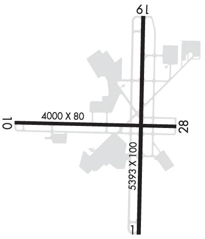
| Lat: N 3450.9 Long: W 08221.0 Elev: 1048 Var: +05 Longest Runway: 5393 | ||
| Dept. ATIS: 127.07 Arr. ATIS: 127.07 AWOS: 127.07 Ground: 121.25 Tower: 119.9 | ||
| |||||||||||||||||||||||
| |||||||||||||||||||||||
| |||||||||||||||||||||||
| |||||||||||||||||||||||
| Rwy | Rwy | |||||||
| 5393x100 | 5393' | 109.70 - 006° | 5393x100 | 5393' | ||||
| 4000x80 | 3733' | 4000x80 | 3729' | |||||
| Runway ID | Single Wheel | Double Wheel | Double Tandem Wheel | Dual Double Wheel |
| 01/19 | 61,000 | 81,000 | 151,000 | N/A |
| 10/28 | 43,500 | 62,000 | N/A | N/A |
| H1 | 20,000 | N/A | N/A | N/A |
| H2 | 20,000 | N/A | N/A | N/A |
| These numbers are Advisory and are not limits. The Airport Manager should have more accurate Weight Limits | ||||
 Airport Diagram might not be current. | |
| Facility Name: | GREENVILLE DOWNTOWN |
| City Name: | GREENVILLE |
| County: | GREENVILLE |
| State abbrev: | SC |
| State Name: | SOUTH CAROLINA |
| Ownership: | PUBLICLY OWNED |
| Use: | OPEN TO THE PUBLIC |
| Owner's Name: | GREENVILLE AIRPORT COMMISSION |
| Address: | 100 TOWER DR, UNIT 2 |
| GREENVILLE, SC 29607 | |
| Owner's Phone: | 864-242-4777 |
| Manager's Name: | JOE FRASHER |
| Address: | 100 TOWER DR, UNIT 2 |
| GREENVILLE, SC 29607 | |
| Phone: | 864-242-4777 |
| FAA Region: | SOUTHERN |
| FAA Field Office: | ATL |
| Date | Sunrise | Sunset |
|---|---|---|
| 09/24/21 Friday | 7:19 | 19:24 |
| 09/25/21 Saturday | 7:19 | 19:22 |
| 09/26/21 Sunday | 7:20 | 19:21 |
| 09/27/21 Monday | 7:21 | 19:19 |
| 09/28/21 Tuesday | 7:22 | 19:18 |
| 09/29/21 Wednesday | 7:22 | 19:17 |
| 09/30/21 Thursday | 7:23 | 19:15 |
| 10/01/21 Friday | 7:24 | 19:14 |
| 10/02/21 Saturday | 7:25 | 19:12 |
| 10/03/21 Sunday | 7:25 | 19:11 |
| 10/04/21 Monday | 7:26 | 19:10 |
| 10/05/21 Tuesday | 7:27 | 19:08 |
| 10/06/21 Wednesday | 7:28 | 19:07 |
| 10/07/21 Thursday | 7:29 | 19:05 |
| Airport Attendance Schedule | MON-FRI 0600-2100, SAT-SUN 0700-2000 |
| Airport Status | OPERATIONAL (This Status can change at any time - please check NOTAMS) |
| Airport Lighting Schedule | ATC-CTL. WHEN ATCT CLSD ACTVT MALSF RWY 01; REIL RWY 19; HIRL RWY 01/19; PERIMETER LGTS H1, H2 - CTAF. |
| Airport Storage Available | Tie Downs, Hanger |
| Extra Services Available | Air Ambulance, Avionics, Cargo Handling, Charter, Flight Instruction, Aircraft Rental, Aircraft Sales, Annual Surveying |
| Wind Indicator | YES - (lighted) |
| Control Tower | YES |
| CTAF Frequency | 119.900 |
| Unicom Frequency | 122.950 |
| Rotating Beacon Color | CLEAR-GREEN (Light Land Airport) |
| Segmented Circle | YES |
| Landing Fee | NO |
| Airport Inspected | STATE - performed by STATE AERONAUTICAL PERSONNEL |
| Inspection Date | 09/23/2019 |
| Type of Fuel Available | Grade 100LL, JET A (freeze point -40C) |
| Airframe Repair Service | MAJOR |
| Power Plant Repair Service | MAJOR |
| Latitude | N3450.9 |
| Longitude | W08221.0 (ESTIMATED) |
| Arpt Elevation | 1048ft (SURVEYED) |
| Magnetic Variation | 05W |
| 3 miles E | of GREENVILLE |
| Traffic Pattern Altitude | 800; TPA: 800 FT AGL FOR LGT ACFT, 1000 FT AGL FOR HVY ACFT. |
| Sectional Chart | ATLANTA |
| Operations (Reported) | Yearly | Avg. Daily |
|---|---|---|
| General Aviation Transient | 22940 | 63 |
| General Aviation Local | 13317 | 36 |
| Air Taxi | 11710 | 32 |
| Commerical | 0 | 0 |
| Commuter | 0 | 0 |
| Military | 1039 | 3 |
| Aircraft based on Field | |
|---|---|
| General Aviation Singles | 140 |
| General Aviation Multi | 19 |
| Jet Aircraft | 18 |
| General Aviation Helicopters | 5 |
| Military Aircraft | 0 |
| Gliders | 0 |
| Ultralights | 0 |
| FSS on field | NO |
| FSS tie-in | ANDERSON |
| FSS Phone | 1-800-WX-BRIEF |
| Who issues Notams | GMU |
| Notam D service at airport | YES |
| ARTCC Name | ATLANTA |
| Airport Certification | |
| Aircraft Rescue & Firefighting Index | None |
| Airport of Entry | No |
| Custom Landing Rights | No |
| Joint Civil/Military | No |
| Military Landing rights | YES |
| NATIONAL PLAN OF INTEGRATED AIRPORT SYSTEMS (NPIAS) |
| GRANT AGREEMENTS UNDER FAAP/ADAP/AIP |
| ASSURANCES PURSUANT TO TITLE VI, CIVIL RIGHTS ACT OF 1964 |
| AGREEMENT UNDER DLAND OR DCLA HAS EXPIRED. |
| ACFT OPER IN THE GREENVILLE ARPT TFC AREA S THRU E BE ALERT FOR JET & CONVENTIONAL TFC DES ON THE GREENVILLE-SPARTANBURG LOC COURSE. |
| ACFT INBD FROM THE SSW OR ON ILS RY 01 APCH BE ALERT FOR TFC 4.5 MI S OPERG IN THE DONALDSON FIELD ARPT TFC PAT AT 1800 FT OR BLO. |
| NO OVERNIGHT PARKING ON HELIPADS. |
| NO ACFT PERMITTED ON TWYS 'C' OR 'D' WHEN ACFT GREATER THAN 12,500 LBS IS OPERATING ON RY 10/28. |
| RY 10/28 RESTRICTED TO SMALL ACFT (LESS THAN 12,500 LBS) WHEN ACFT OPERG ON TWYS C OR D. |
| NOISE ABATEMENT PROCEDURES IN EFFECT, CTC ARPT MGR 864-242-4777. |
| RWY 01/1 9 ARRESTING GEAR/SYSTEM: ENGINEERED MATERIAL ARRESTING SYSTEM (EMAS) 157 FT IN LENGTH BY 113 FT IN WIDTH AT THE DEPARTURE END OF RWY 01. |
Airport Communications & Frequencies:
| |||||||||||||||||||||||||
| Runway: 01 | Runway: 19 | ||
| Mag heading: | 6° | Mag heading: | 186° |
| Rwy Slope: | 1.10% Up | Rwy Slope: | -1.10% Down |
| Approach: | ILS | Approach: | |
| Pattern: | Left Traffic | Pattern: | Right Traffic |
| Markings: | PRECISION INSTRUMENT | Markings: | NONPRECISION INSTRUMENT |
| Marking Condition: | GOOD | Marking Condition: | GOOD |
| Arresting Dev: | EMAS | Arresting Dev: | |
| Lat & Long: | N3450.4 W08220.9 | Lat. & Long.: | N3451.3 W08220.9 |
| Elev: | 988.6 ft. MSL | Elev: | 1048.0 ft. MSL |
| TCH: | 35 ft. AGL | TCH: | 37 ft. AGL |
| Visual Glide Path: | 3.00 degrees | Visual Glide Path: | 3.50 degrees |
| Displaced Threshold: | No | Displaced Threshold: | No |
| Touchdown Zone: | YES | Touchdown Zone: | YES |
| Touchdown Elev.: | 1015.4 feet | Touchdown Elev.: | 1048.0 feet |
| Visual Glide Slope: | 4-Light PAPI on LEFT side of Runway | Visual Glide Slope: | 4-Light PAPI on LEFT side of Runway |
| RVR Equipment: | RVR Equipment: | ||
| RVV Equipment: | NO | RVV Equipment: | NO |
| Approach Lights: | MALSF - 1,400 foot medium intensity approach lighting system with sequenced flashers | Approach Lights: | |
| REIL: | NO | REIL: | YES |
| Centerline Lights: | NO | Centerline Lights: | NO |
| Touchdown lights: | NO | Touchdown lights: | NO |
| Runway Category: | Precision Instrument Runway | Runway Category: | Runway with a Non-precision Approach having visibility minimums greater than 3/4 mile |
| Declared Distances: | Declared Distances: | ||
| Obstructions: | Obstructions: | TREE | |
| Marked: | Marked: | NOT Marked/Lighted | |
| Clearance slope: | 50:1 | Clearance slope: | 20:1 |
| Obstruction height: | Obstruction height: | 115 feet AGL | |
| Dist. from runway: | Dist. from runway: | 2580 feet | |
| Centerline offset: | Centerline offset: | 406 feet left of centerline | |
| Comments: | Comments: |
| Runway: 10 | Runway: 28 | ||
| Mag heading: | 96° | Mag heading: | 276° |
| Rwy Slope: | .51% Up | Rwy Slope: | -.51% Down |
| Approach: | Approach: | ||
| Pattern: | Left Traffic | Pattern: | Right Traffic |
| Markings: | BASIC | Markings: | BASIC |
| Marking Condition: | GOOD | Marking Condition: | GOOD |
| Arresting Dev: | Arresting Dev: | ||
| Lat & Long: | N3450.9 W08221.5 | Lat. & Long.: | N3450.9 W08220.7 |
| Elev: | 994.3 ft. MSL | Elev: | 1014.7 ft. MSL |
| TCH: | TCH: | 40 ft. AGL | |
| Visual Glide Path: | Visual Glide Path: | 3.00 degrees | |
| Displaced Threshold: | 267 feet | Displaced Threshold: | 271 feet |
| Touchdown Zone: | YES | Touchdown Zone: | YES |
| Touchdown Elev.: | 1013.3 feet | Touchdown Elev.: | 1013.3 feet |
| Visual Glide Slope: | Visual Glide Slope: | 2-Light PAPI on LEFT side of Runway | |
| RVR Equipment: | RVR Equipment: | ||
| RVV Equipment: | NO | RVV Equipment: | NO |
| Approach Lights: | Approach Lights: | ||
| REIL: | NO | REIL: | YES |
| Centerline Lights: | NO | Centerline Lights: | NO |
| Touchdown lights: | NO | Touchdown lights: | NO |
| Runway Category: | Runway with a Non-precision Approach having visibility minimums greater than 3/4 mile | Runway Category: | Runway with a Non-precision Approach having visibility minimums greater than 3/4 mile |
| Declared Distances: | TORA:3998' TODA:3998' ASDA:3728' LDA:3463' | Declared Distances: | TORA:3998' TODA:3998' ASDA:3733' LDA:3463' |
| Obstructions: | TREE | Obstructions: | TREE |
| Marked: | NOT Marked/Lighted | Marked: | NOT Marked/Lighted |
| Clearance slope: | 14:1; RY 10 APCH IS 28:1 AT DSPLCD THLD. | Clearance slope: | 12:1; RY 28 APCH IS 36:1 AT DSPLCD THLD. |
| Obstruction height: | 34 feet AGL | Obstruction height: | 19 feet AGL |
| Dist. from runway: | 707 feet | Dist. from runway: | 444 feet |
| Centerline offset: | 188 left of centerline | Centerline offset: | 110 feet right of centerline |
| Comments: | Comments: |
Thanks for using FltPlan.com
all rights reserved © 1999-2021 by Flight Plan LLC

