| Rwy | Length | Land Dist Avail** | Approach* | | Rwy | Length | Land Dist Avail** | Approach* | | 11 | 3800x50 | 3800' | | | 29 | 3800x50 | 3800' | | | * only ILS, LOC, LDA, and SDF approaches to a specific runway are shown** For any Declared Landing Distance Available, please see A/FD or Approach plates |
| Runway Weight Capability (lbs.) more info on Runway Weight Capability | | Runway ID | Single Wheel | Double Wheel | Double Tandem Wheel | Dual Double Wheel | These numbers are Advisory and are not limits. The Airport Manager should have more accurate Weight Limits
Please email Support@FltPlan.com for further information. |
| Approach Charts FltPlan does not have IFR approaches charts available for KHAX. |
|
| Customs Information ( Send updates to Support@FltPlan.com ) |
| Database effective date: 05/26/2016 |
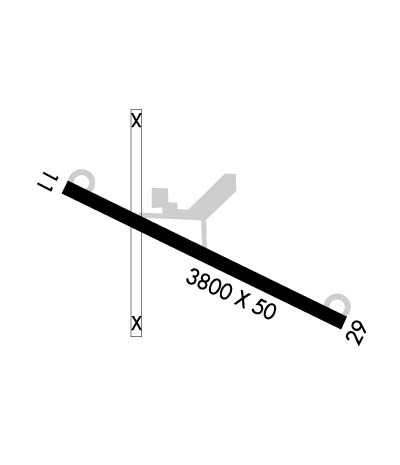
Airport Diagram might not be current.
| | Facility Name: | HATBOX FIELD | | City Name: | MUSKOGEE | | County: | MUSKOGEE | | State abbrev: | OK | | State Name: | OKLAHOMA | | | | | Ownership: | PUBLICLY OWNED | | Use: | OPEN TO THE PUBLIC | | Owner's Name: | CITY OF MUSKOGEE | | Address: | MUNICIPAL BLDG | | | MUSKOGEE, OK 74401 | | Owner's Phone: | (918) 684-6201 | | | | | Manager's Name: | RJ HARRIS | | Address: | MUNICIPAL BUILDING, PO BOX 1927 | | | MUSKOGEE, OK 74402 | | Phone: | (918) 684-6343 | | | | | FAA Region: | SOUTHWEST | | FAA Field Office: | AOK |
| 

Click here for full scale & interactive Sectional view of KHAX
|
| Sunrise / Sunset times for: HATBOX FIELD | | Date: | Sunrise | Sunset | | 04/22/17 Saturday | 6:40 | 20:01 | | 04/23/17 Sunday | 6:39 | 20:02 | | 04/24/17 Monday | 6:38 | 20:02 | | 04/25/17 Tuesday | 6:37 | 20:03 | | 04/26/17 Wednesday | 6:35 | 20:04 | | 04/27/17 Thursday | 6:34 | 20:05 | | 04/28/17 Friday | 6:33 | 20:06 |
| : | | Date: | Sunrise | Sunset | | 04/29/17 Saturday | 6:32 | 20:07 | | 04/30/17 Sunday | 6:31 | 20:07 | | 05/01/17 Monday | 6:30 | 20:08 | | 05/02/17 Tuesday | 6:29 | 20:09 | | 05/03/17 Wednesday | 6:28 | 20:10 | | 05/04/17 Thursday | 6:27 | 20:11 | | 05/05/17 Friday | 6:26 | 20:12 |
|
|
| Airport Facilities | Airport Attendance Schedule: UNATTENDED
Airport Status: CLOSED INDEFINITELY (This Status can change at any time - please check NOTAMS)
Airport Lighting Schedule:
Airport Storage Available: NONE
Extra Services Available: NONE
Wind Indicator: NONEControl Tower: NO
CTAF Frequency: 122.900
Unicom Frequency: | Rotating Beacon Color:
Segmented Circle: NO | | Landing Fee: NO | |
|
| Airport Services | Type of Fuel Available: None
Airframe Repair Service: None
Power Plant Repair Service: None |
|
| Geographic Data | | Latitude: N3544.8 Longitude: W09524.8 (ESTIMATED) | | Arpt Elevation: 627ft (SURVEYED) | | | Magnetic Variation: 06E | | 2 miles W of MUSKOGEE | | Traffic Pattern Altitude: | | Sectional Chart: DALLAS-FT WORTH |
|
| Aircraft Data | | Operations (reported) | Yearly | Avg. Daily | | General Aviation transient: | 0 | 0 | | General Aviation Local: | 0 | 0 | | Air Taxi: | 0 | 0 | | Commerical: | 0 | 0 | | Commuter: | 0 | 0 | | Military: | 0 | 0 |
| | Aircraft based on Field | | General Aviation Singles: | 17 | | General Aviation Multi: | 0 | | Jet Aircraft: | 0 | | General Aviation Helicopters: | 0 | | Military Aircraft: | 0 | | Gliders: | 0 | | Ultralights: | 0 |
|
|
| FAA Services | FSS on field: NO
FSS tie-in:MC ALESTER
FSS Phone: 1-800-WX-BRIEFWho issues Notams: MLC
Notam D service at airport: YES
ARTCC Name: FORT WORTH | |
|
|
| Federal Status | Airport Certification:
Aircraft Rescue & Firefighting Index: NoneAirport of Entry: No
Custom Landing Rights: No | Joint Civil/Military: No
Military Landing rights: YES | |
|
|
Runway Identification: 11/29Length: 3800 ft
Width: 50 ft
Surface: ASPHALT-FAIR CONDITION
Edge lights:
|
| |
| | Mag heading: | N/A | Mag heading: | N/A | | Approach: | | Approach: | | | Pattern: | Right Traffic | Pattern: | Left Traffic | | Markings: | | Markings: | | | Marking Condition: | YELLOW "X" AT END OF RUNWAY. | Marking Condition: | YELLOW "X" AT END OF RY. | | Arresting Dev: | | Arresting Dev: | | | Lat & Long: | | Lat. & Long.: | | | Elev: | N/A | Elev: | N/A | | TCH: | | TCH: | | | Visual Glide Path: | | Visual Glide Path: | | | Displaced Threshold: | No | Displaced Threshold: | No | | Touchdown Zone: | NO | Touchdown Zone: | NO | | Touchdown Elev.: | | Touchdown Elev.: | | | Visual Glide Slope: | | Visual Glide Slope: | | | RVR Equipment: | | RVR Equipment: | | | RVV Equipment: | NO | RVV Equipment: | NO | | Approach Lights: | | Approach Lights: | | | REIL: | NO | REIL: | NO | | Centerline Lights: | NO | Centerline Lights: | NO | | Touchdown lights: | NO | Touchdown lights: | NO | | Runway Category: | Runway with a Visual Approach | Runway Category: | Runway with a Visual Approach | | Declared Distances: | | Declared Distances: | | | Obstructions: | TREES | Obstructions: | TREES | | Marked: | NOT Marked/Lighted | Marked: | NOT Marked/Lighted | | Clearance slope: | 3:1 | Clearance slope: | 3:1 | | Obstruction height: | 55 feet AGL | Obstruction height: | 65 feet AGL | | Dist. from runway: | 370 feet | Dist. from runway: | 400 feet | | Centerline offset: | | Centerline offset: | 100 feet left of centerline | | Comments: | 15 FT TREES 75 FT L OF CENTERLINE AND 0 FT FROM RUNWAY END | Comments: | |
|
| Remarks | | (ARPT STATUS) ARPT CLSD INDEFLY.RWY 11/2 9 RY CLSD INDEFLY. |
|
| Federal Agreements | | GRANT AGREEMENTS UNDER FAAP/ADAP/AIPSURPLUS PROPERTY AGREEMENT UNDER REGULATION 16-WAAASSURANCES PURSUANT TO TITLE VI, CIVIL RIGHTS ACT OF 1964AGREEMENT UNDER DLAND OR DCLA HAS EXPIRED. |
|
| Airport Inspection Data | Airport Inspected: STATE - performed by STATE AERONAUTICAL PERSONNEL
Inspection Date: 06/16/2015 |
|
//
Thanks for using FltPlan.com
all rights reserved © copyright 1999-2017 by Flight Plan LLC |