
| HAGERSTOWN RGNL- HENSON HAGERSTOWN MD |
| |
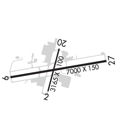
| Lat: N 3942.5 Long: W 07743.6 Elev: 703 Var: +11 Longest Runway: 7000 | ||
| AWOS: 126.37 Ground: 120.8 Tower: 120.3 | ||
| ||||||||||||||||||||||||||||||||||||||||||||
| ||||||||||||||||||||||||||||||||||||||||||||
| ||||||||||||||||||||||||||||||||||||||||||||
| Rwy | Rwy | |||||||
| 3165x100 | 3165' | 3165x100 | 3165' | |||||
| 7000x150 | 7000' | 111.90 - 091° | 7000x150 | 7000' | 111.90 - 271° | |||
| Runway ID | Single Wheel | Double Wheel | Double Tandem Wheel | Dual Double Wheel |
| 02/20 | 80,000 | 100,000 | 170,000 | N/A |
| 09/27 | 100,000 | 150,000 | 250,000 | N/A |
| These numbers are Advisory and are not limits. The Airport Manager should have more accurate Weight Limits | ||||
 Airport Diagram might not be current. | |
| Facility Name: | HAGERSTOWN RGNL-RICHARD A HENSON FLD |
| City Name: | HAGERSTOWN |
| County: | WASHINGTON |
| State abbrev: | MD |
| State Name: | MARYLAND |
| Ownership: | PUBLICLY OWNED |
| Use: | OPEN TO THE PUBLIC |
| Owner's Name: | WASHINGTON COUNTY |
| Address: | 100 WEST WASHINGTON ST |
| HAGERSTOWN, MD 21740 | |
| Owner's Phone: | 240-313-2200 |
| Manager's Name: | RICK JOHNSON |
| Address: | 18434 SHOWALTER RD |
| HAGERSTOWN, MD 21742 | |
| Phone: | 240-313-2777 |
| FAA Region: | EASTERN |
| FAA Field Office: | DCA |
| Date | Sunrise | Sunset |
|---|---|---|
| 09/24/21 Friday | 7:00 | 19:05 |
| 09/25/21 Saturday | 7:01 | 19:03 |
| 09/26/21 Sunday | 7:02 | 19:02 |
| 09/27/21 Monday | 7:03 | 19:00 |
| 09/28/21 Tuesday | 7:04 | 18:59 |
| 09/29/21 Wednesday | 7:05 | 18:57 |
| 09/30/21 Thursday | 7:06 | 18:55 |
| 10/01/21 Friday | 7:07 | 18:54 |
| 10/02/21 Saturday | 7:08 | 18:52 |
| 10/03/21 Sunday | 7:09 | 18:51 |
| 10/04/21 Monday | 7:10 | 18:49 |
| 10/05/21 Tuesday | 7:11 | 18:47 |
| 10/06/21 Wednesday | 7:12 | 18:46 |
| 10/07/21 Thursday | 7:13 | 18:44 |
| Airport Attendance Schedule | 7 Days A Week 0500-2200; AIRPORT UNATTND 2200-0500 |
| Airport Status | OPERATIONAL (This Status can change at any time - please check NOTAMS) |
| Airport Lighting Schedule | WHEN ATCT CLSD ACTVT MALSR RY 27; REIL RY 09; HIRL RY 09/27 - CTAF. |
| Airport Storage Available | Tie Downs, Hanger |
| Extra Services Available | Air Freight, Air Ambulance, Avionics, Cargo Handling, Charter, Flight Instruction, Parachute Jumping, Aircraft Rental, Aircraft Sales, Annual Surveying |
| Wind Indicator | YES - (lighted) |
| Control Tower | YES |
| CTAF Frequency | 120.300 |
| Unicom Frequency | 122.950 |
| Rotating Beacon Color | CLEAR-GREEN (Light Land Airport) |
| Segmented Circle | NO |
| Landing Fee | YES |
| Airport Inspected | FEDERAL - performed by FAA AIRPORTS FIELD PERSONNEL |
| Inspection Date | 04/13/2021 |
| Type of Fuel Available | Grade 100LL, JET A (freeze point -40C), JET A-1 (freeze point -50C); -10FUEL AVBL 0500-2200 CALL 301-791-9119. DOD CONTRACT FUEL AVBL. |
| Airframe Repair Service | MAJOR |
| Power Plant Repair Service | MAJOR |
| Latitude | N3942.5 |
| Longitude | W07743.6 (ESTIMATED) |
| Arpt Elevation | 703ft (SURVEYED) |
| Magnetic Variation | 11W |
| 4 miles N | of HAGERSTOWN |
| Traffic Pattern Altitude | |
| Sectional Chart | WASHINGTON |
| Operations (Reported) | Yearly | Avg. Daily |
|---|---|---|
| General Aviation Transient | 0 | 0 |
| General Aviation Local | 28367 | 78 |
| Air Taxi | 1910 | 5 |
| Commerical | 326 | 1 |
| Commuter | 0 | 0 |
| Military | 4151 | 11 |
| Aircraft based on Field | |
|---|---|
| General Aviation Singles | 67 |
| General Aviation Multi | 8 |
| Jet Aircraft | 1 |
| General Aviation Helicopters | 1 |
| Military Aircraft | 0 |
| Gliders | 0 |
| Ultralights | 1 |
| FSS on field | NO |
| FSS tie-in | LEESBURG |
| FSS Phone | 1-800-WX-BRIEF |
| Who issues Notams | HGR |
| Notam D service at airport | YES |
| ARTCC Name | WASHINGTON |
| Airport Certification | AIRPORT RECEIVING SCHEDULED AIR CARRIER SERVICE FROM CARRIERS CERTIFICATED BY THE CIVIL AERONAUTICS BOARD; PPR 24 HRS FOR UNSKED ACR OPNS WITH MORE THAN 30 PSGR SEATS CALL AMGR 240-313-2777. |
| Aircraft Rescue & Firefighting Index | AIRPORT HAS A CERTIFICATE UNDER CFR PART 139 |
| Airport of Entry | No |
| Custom Landing Rights | No |
| Joint Civil/Military | No |
| Military Landing rights | YES |
| NATIONAL PLAN OF INTEGRATED AIRPORT SYSTEMS (NPIAS) |
| GRANT AGREEMENTS UNDER FAAP/ADAP/AIP |
| COMPLIANCE WITH ACCESSIBILITY TO THE HANDICAPPED |
| ASSURANCES PURSUANT TO TITLE VI, CIVIL RIGHTS ACT OF 1964 |
| AGREEMENT UNDER DLAND OR DCLA HAS EXPIRED. |
| RY 02/20 CLSD WHEN ATCT CLSD. |
| FOR CD WHEN ATCT IS CLSD CTC POTOMAC APCH AT 866-709-4993. |
| BIRDS ON & INVOF ARPT. |
| LOW LEVEL MILITARY ACFT 10 NM NORTH ON VR708 OPERATING EAST TO WEST. |
| ULTRA-LGT ACTIVITY 12 NM EAST TO 5000 FT MSL. |
| TXY "P" NOT AVBL FOR AIR CARRIER OPS. |
Airport Communications & Frequencies:
| |||||||||||||||||||||||||||
| Runway: 02 | Runway: 20 | ||
| Mag heading: | 26° | Mag heading: | 206° |
| Rwy Slope: | .34% Up | Rwy Slope: | -.34% Down |
| Approach: | Approach: | ||
| Pattern: | Left Traffic | Pattern: | Left Traffic |
| Markings: | BASIC | Markings: | BASIC |
| Marking Condition: | GOOD | Marking Condition: | GOOD |
| Arresting Dev: | Arresting Dev: | ||
| Lat & Long: | N3942.3 W07743.7 | Lat. & Long.: | N3942.8 W07743.6 |
| Elev: | 692.0 ft. MSL | Elev: | 702.9 ft. MSL |
| TCH: | 53 ft. AGL | TCH: | 33 ft. AGL |
| Visual Glide Path: | 4.00 degrees | Visual Glide Path: | 4.00 degrees |
| Displaced Threshold: | No | Displaced Threshold: | No |
| Touchdown Zone: | YES | Touchdown Zone: | YES |
| Touchdown Elev.: | 700.1 feet | Touchdown Elev.: | 703.1 feet |
| Visual Glide Slope: | 2-Light PAPI on LEFT side of Runway | Visual Glide Slope: | 2-Light PAPI on LEFT side of Runway |
| RVR Equipment: | RVR Equipment: | ||
| RVV Equipment: | NO | RVV Equipment: | NO |
| Approach Lights: | Approach Lights: | ||
| REIL: | YES | REIL: | YES |
| Centerline Lights: | NO | Centerline Lights: | NO |
| Touchdown lights: | NO | Touchdown lights: | NO |
| Runway Category: | Runway with a Visual Approach | Runway Category: | Runway with a Visual Approach |
| Declared Distances: | TORA:3165' TODA:3165' ASDA:3165' LDA:3165' | Declared Distances: | TORA:3165' TODA:3165' ASDA:3165' LDA:3165' |
| Runway: 09 | Runway: 27 | ||
| Mag heading: | 91° | Mag heading: | 272° |
| Rwy Slope: | .30% Up | Rwy Slope: | -.30% Down |
| Approach: | ILS/DME | Approach: | ILS/DME |
| Pattern: | Left Traffic | Pattern: | Left Traffic |
| Markings: | PRECISION INSTRUMENT | Markings: | PRECISION INSTRUMENT |
| Marking Condition: | GOOD | Marking Condition: | GOOD |
| Arresting Dev: | Arresting Dev: | ||
| Lat & Long: | N3942.4 W07744.3 | Lat. & Long.: | N3942.6 W07742.8 |
| Elev: | 664.4 ft. MSL | Elev: | 685.5 ft. MSL |
| TCH: | 55 ft. AGL | TCH: | 55 ft. AGL |
| Visual Glide Path: | 3.00 degrees | Visual Glide Path: | 3.00 degrees |
| Displaced Threshold: | No | Displaced Threshold: | No |
| Touchdown Zone: | YES | Touchdown Zone: | YES |
| Touchdown Elev.: | 695.3 feet | Touchdown Elev.: | 701.2 feet |
| Visual Glide Slope: | 4-Light PAPI on LEFT side of Runway | Visual Glide Slope: | 4-Light PAPI on LEFT side of Runway |
| RVR Equipment: | RVR Equipment: | ||
| RVV Equipment: | NO | RVV Equipment: | NO |
| Approach Lights: | Approach Lights: | MALSR - 1,400 foot medium intensity approach lighting system with runway alignment indicator lights | |
| REIL: | YES | REIL: | NO |
| Centerline Lights: | NO | Centerline Lights: | NO |
| Touchdown lights: | NO | Touchdown lights: | NO |
| Runway Category: | Precision Instrument Runway | Runway Category: | Precision Instrument Runway |
| Declared Distances: | TORA:7000' TODA:7000' ASDA:7000' LDA:7000' | Declared Distances: | TORA:7000' TODA:7000' ASDA:7000' LDA:7000' |
Thanks for using FltPlan.com
all rights reserved © 1999-2021 by Flight Plan LLC
