| HILLENBRAND INDUSTRIES BATESVILLE IN |
| |
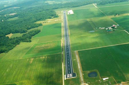
| Lat: N 3920.6 Long: W 08515.5 Elev: 975 Var: +05 Longest Runway: 5933 | ||
| CTAF: 122.72 | ||
| ||||||||||||||||||||||||||||||||
| ||||||||||||||||||||||||||||||||
| Rwy | Rwy | |||||||
| 5933x100 | 5354' | 5933x100 | 5933' | |||||
| Runway ID | Single Wheel | Double Wheel | Double Tandem Wheel | Dual Double Wheel |
| 18/36 | N/A | N/A | N/A | N/A |
| These numbers are Advisory and are not limits. The Airport Manager should have more accurate Weight Limits | ||||
| FltPlan does not have IFR approach charts available for KHLB. |
| Facility Name: | BATESVILLE |
| City Name: | BATESVILLE |
| County: | FRANKLIN |
| State abbrev: | IN |
| State Name: | INDIANA |
| Ownership: | PRIVATELY OWNED |
| Use: | OPEN TO THE PUBLIC |
| Owner's Name: | EAST WEST HELICOPTER, INC. |
| Address: | 25222 ENOCHSBURG RD. |
| BATESVILLE, IN 47006 | |
| Owner's Phone: | 812-934-7593 |
| Manager's Name: | PATRIC WELLS |
| Address: | 25222 ENOCHSBURG RD. |
| BATESVILLE, IN 47006 | |
| Phone: | 812-934-7593 |
| FAA Region: | GREAT LAKES |
| FAA Field Office: | CHI |
| Date | Sunrise | Sunset |
|---|---|---|
| 02/11/25 Tuesday | 7:38 | 18:13 |
| 02/12/25 Wednesday | 7:37 | 18:14 |
| 02/13/25 Thursday | 7:36 | 18:15 |
| 02/14/25 Friday | 7:35 | 18:17 |
| 02/15/25 Saturday | 7:33 | 18:18 |
| 02/16/25 Sunday | 7:32 | 18:19 |
| 02/17/25 Monday | 7:31 | 18:20 |
| 02/18/25 Tuesday | 7:30 | 18:21 |
| 02/19/25 Wednesday | 7:28 | 18:22 |
| 02/20/25 Thursday | 7:27 | 18:23 |
| 02/21/25 Friday | 7:26 | 18:25 |
| 02/22/25 Saturday | 7:24 | 18:26 |
| 02/23/25 Sunday | 7:23 | 18:27 |
| 02/24/25 Monday | 7:21 | 18:28 |
| Airport Attendance Schedule | MON-FRI 0800-1700 LOCAL |
| Airport Status | OPERATIONAL (This Status can change at any time - please check NOTAMS) |
| Airport Lighting Schedule | ACTVT HIRL RWY 18/36 - CTAF. |
| Airport Storage Available | Tie Downs, Hanger |
| Extra Services Available | NONE |
| Wind Indicator | YES - (unlit) |
| Control Tower | NO |
| CTAF Frequency | 122.725 |
| Unicom Frequency | 122.725 |
| Rotating Beacon Color | WG |
| Segmented Circle | NO |
| Landing Fee | NO |
| Airport Inspected | 5010-2 PRIVATE USE MAILOUT PROGRAM - performed by STATE AERONAUTICAL PERSONNEL |
| Inspection Date | 07/19/2022 |
| Type of Fuel Available | JET A (freeze point -40C) |
| Airframe Repair Service | MAJOR |
| Power Plant Repair Service | MINOR |
| Latitude | N3920.6 |
| Longitude | W08515.5 (ESTIMATED) |
| Arpt Elevation | 975ft (SURVEYED) |
| Magnetic Variation | 05W |
| 3 miles NW | of BATESVILLE |
| Traffic Pattern Altitude | |
| Sectional Chart | ST LOUIS |
| Operations (Reported) | Yearly | Avg. Daily |
|---|---|---|
| General Aviation Transient | 0 | 0 |
| General Aviation Local | 0 | 0 |
| Air Taxi | 0 | 0 |
| Commerical | 0 | 0 |
| Commuter | 0 | 0 |
| Military | 0 | 0 |
| Aircraft based on Field | |
|---|---|
| General Aviation Singles | 0 |
| General Aviation Multi | 0 |
| Jet Aircraft | 0 |
| General Aviation Helicopters | 0 |
| Military Aircraft | 0 |
| Gliders | 0 |
| Ultralights | 0 |
| FSS on field | NO |
| FSS tie-in | TERRE HAUTE |
| FSS Phone | 1-800-WX-BRIEF |
| Who issues Notams | HUF |
| Notam D service at airport | No |
| ARTCC Name | INDIANAPOLIS |
| Airport Certification | |
| Aircraft Rescue & Firefighting Index | None |
| Airport of Entry | No |
| Custom Landing Rights | No |
| Joint Civil/Military | No |
| Military Landing rights | No |
| FOR CD CTC CINCINNATI APCH AT 859-372-6440 |
| LNDG FAC IS FQTLY USED FOR MED AMBULANCE PURPOSES. |
Airport Communications & Frequencies:
| ||||||||||||||
| Runway: 18 | Runway: 36 | ||
| Mag heading: | N/A | Mag heading: | N/A |
| Rwy Slope: | -.01% Down | Rwy Slope: | .01% Up |
| Approach: | Approach: | ||
| Pattern: | Left Traffic | Pattern: | Left Traffic |
| Markings: | Markings: | ||
| Marking Condition: | Marking Condition: | ||
| Arresting Dev: | Arresting Dev: | ||
| Lat & Long: | N3921.1 W08515.5 | Lat. & Long.: | N3920.1 W08515.5 |
| Elev: | 975.0 ft. MSL | Elev: | 974.6 ft. MSL |
| TCH: | TCH: | 30 ft. AGL | |
| Visual Glide Path: | Visual Glide Path: | 3.00 degrees | |
| Displaced Threshold: | 579 feet | Displaced Threshold: | No |
| Touchdown Zone: | YES | Touchdown Zone: | YES |
| Touchdown Elev.: | 974.9 feet | Touchdown Elev.: | 974.9 feet |
| Visual Glide Slope: | Visual Glide Slope: | 2-Light PAPI on RIGHT side of Runway | |
| RVR Equipment: | RVR Equipment: | ||
| RVV Equipment: | NO | RVV Equipment: | NO |
| Approach Lights: | Approach Lights: | ||
| REIL: | YES | REIL: | YES |
| Centerline Lights: | NO | Centerline Lights: | NO |
| Touchdown lights: | NO | Touchdown lights: | NO |
| Runway Category: | Runway with a Visual Approach | Runway Category: | Runway with a Visual Approach |
| Declared Distances: | Declared Distances: | ||
| Obstructions: | TREES | Obstructions: | TREE |
| Marked: | NOT Marked/Lighted | Marked: | NOT Marked/Lighted |
| Clearance slope: | 5:1; APCH RATIO 17:1 TO DTHR. | Clearance slope: | 1:1 |
| Obstruction height: | 67 feet AGL | Obstruction height: | 27 feet AGL |
| Dist. from runway: | 600 feet | Dist. from runway: | 250 feet |
| Centerline offset: | 65 left of centerline | Centerline offset: | 160 feet right of centerline |
| Comments: | BLAST FENCE 10 FT FM RWY END; ROAD 25 FT FM RWY END; CROPS 60 FT FM RWY END. | Comments: |
Thanks for using FltPlan.com
all rights reserved © 1999-2025 by Flight Plan LLC