
| HELENA RGNL HELENA MT |
| |
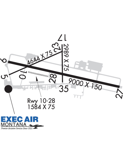
| Lat: N 4636.4 Long: W 11159.0 Elev: 3877 Var: -16 Longest Runway: 9000 | ||
| Dept. ATIS: 120.4 Arr. ATIS: 120.4 Ground: 121.9 Tower: 118.3 | ||
| |||||||||||||||||||||||||||||||||||||||||||||||||||||||||||||
| |||||||||||||||||||||||||||||||||||||||||||||||||||||||||||||
| |||||||||||||||||||||||||||||||||||||||||||||||||||||||||||||
| Rwy | Rwy | |||||||
| 4644x75 | 4644' | 4644x75 | 4644' | |||||
| 9000x150 | 9000' | 9000x150 | 9000' | 110.10 - 266° | ||||
| 1584x75 | 1584' | 1584x75 | 1584' | |||||
| 2989x75 | 2989' | 2989x75 | 2989' | |||||
| Runway ID | Single Wheel | Double Wheel | Double Tandem Wheel | Dual Double Wheel |
| 05/23 | 21,000 | 30,000 | N/A | N/A |
| 09/27 | N/A | 160,000 | 250,000 | 420,000 |
| 10/28 | N/A | N/A | N/A | N/A |
| 17/35 | N/A | N/A | N/A | N/A |
| These numbers are Advisory and are not limits. The Airport Manager should have more accurate Weight Limits | ||||
 Airport Diagram might not be current. | |
| Facility Name: | HELENA RGNL |
| City Name: | HELENA |
| County: | LEWIS AND CLARK |
| State abbrev: | MT |
| State Name: | MONTANA |
| Ownership: | PUBLICLY OWNED |
| Use: | OPEN TO THE PUBLIC |
| Owner's Name: | HELENA REG ARPT AUTH |
| Address: | 2850 MERCER LOOP |
| HELENA, MT 59602 | |
| Owner's Phone: | 406-442-2821 |
| Manager's Name: | JEFF WADEKAMPER |
| Address: | 2850 MERCER LOOP |
| HELENA, MT 59602 | |
| Phone: | 406-442-2821 |
| FAA Region: | NORTHWEST MOUNTAIN |
| FAA Field Office: | HLN |
| Date | Sunrise | Sunset |
|---|---|---|
| 09/24/21 Friday | 7:17 | 19:22 |
| 09/25/21 Saturday | 7:18 | 19:20 |
| 09/26/21 Sunday | 7:20 | 19:18 |
| 09/27/21 Monday | 7:21 | 19:16 |
| 09/28/21 Tuesday | 7:22 | 19:14 |
| 09/29/21 Wednesday | 7:24 | 19:12 |
| 09/30/21 Thursday | 7:25 | 19:10 |
| 10/01/21 Friday | 7:26 | 19:08 |
| 10/02/21 Saturday | 7:28 | 19:06 |
| 10/03/21 Sunday | 7:29 | 19:04 |
| 10/04/21 Monday | 7:30 | 19:02 |
| 10/05/21 Tuesday | 7:32 | 19:00 |
| 10/06/21 Wednesday | 7:33 | 18:58 |
| 10/07/21 Thursday | 7:34 | 18:56 |
| Airport Attendance Schedule | 7 Days A Week 0500-0100 |
| Airport Status | OPERATIONAL (This Status can change at any time - please check NOTAMS) |
| Airport Lighting Schedule | WHEN ATCT CLSD ACTVT MALSR RWY 27; REIL RWY 09, 17 & 35; PAPI RWY 09 & 27; HIRL RWY 09/27; MIRL RWY 05/23 & 17/35; - CTAF. |
| Airport Storage Available | Tie Downs, Hanger |
| Extra Services Available | Air Freight, Crop Dusting, Air Ambulance, Cargo Handling, Charter, Flight Instruction, Aircraft Rental, Aircraft Sales, Annual Surveying |
| Wind Indicator | YES - (lighted) |
| Control Tower | YES |
| CTAF Frequency | 118.300 |
| Unicom Frequency | 122.950 |
| Rotating Beacon Color | CLEAR-GREEN (Light Land Airport) |
| Segmented Circle | YES |
| Landing Fee | YES; LNDG FEE FOR ALL COMMERCIAL ACFT & ALL ACFT OVER 10000 LBS. |
| Airport Inspected | FEDERAL - performed by FAA AIRPORTS FIELD PERSONNEL |
| Inspection Date | 04/23/2021 |
| Type of Fuel Available | Grade 100, Grade 100LL, Grade 80, JET A (freeze point -40C) |
| Airframe Repair Service | MAJOR |
| Power Plant Repair Service | MAJOR |
| Latitude | N4636.4 |
| Longitude | W11159.0 (ESTIMATED) |
| Arpt Elevation | 3877ft (SURVEYED) |
| Magnetic Variation | 16E |
| 2 miles NE | of HELENA |
| Traffic Pattern Altitude | |
| Sectional Chart | GREAT FALLS |
| Operations (Reported) | Yearly | Avg. Daily |
|---|---|---|
| General Aviation Transient | 10901 | 30 |
| General Aviation Local | 15619 | 43 |
| Air Taxi | 2426 | 7 |
| Commerical | 2175 | 6 |
| Commuter | 0 | 0 |
| Military | 2281 | 6 |
| Aircraft based on Field | |
|---|---|
| General Aviation Singles | 157 |
| General Aviation Multi | 27 |
| Jet Aircraft | 6 |
| General Aviation Helicopters | 22 |
| Military Aircraft | 23 |
| Gliders | 0 |
| Ultralights | 2 |
| FSS on field | NO |
| FSS tie-in | GREAT FALLS |
| FSS Phone | 1-800-WX-BRIEF |
| Who issues Notams | HLN |
| Notam D service at airport | YES |
| ARTCC Name | SALT LAKE CITY |
| Airport Certification | AIRPORT RECEIVING SCHEDULED AIR CARRIER SERVICE FROM CARRIERS CERTIFICATED BY THE CIVIL AERONAUTICS BOARD; ARFF COVERAGE PRVDD FOR SKED PART 121 ACRS ONLY EXCP WITH PRIOR APPROVAL - CALL 406-442-2821. |
| Aircraft Rescue & Firefighting Index | AIRPORT HAS A CERTIFICATE UNDER CFR PART 139 |
| Airport of Entry | No |
| Custom Landing Rights | YES |
| Joint Civil/Military | No |
| Military Landing rights | YES |
| NATIONAL PLAN OF INTEGRATED AIRPORT SYSTEMS (NPIAS) |
| GRANT AGREEMENTS UNDER FAAP/ADAP/AIP |
| ASSURANCES PURSUANT TO TITLE VI, CIVIL RIGHTS ACT OF 1964 |
| AGREEMENT UNDER DLAND OR DCLA HAS EXPIRED. |
| FLIGHT NOTIFICATION SERVICE (ADCUS) AVBL. |
| ARNG: FT HARRISON AAF (MT15) WITHIN CLASS D CONTACT MT ARNG OPS C406 324-5775/76 DSN 324-5775/76 FOR PARADROP OPERATIONS INFORMATION AND HOURS. |
| FOR CD IF UNA TO CTC ON FSS FREQ, CTC SALT LAKE ARTCC AT 801-320-2568. |
| RY 17/35 & RY 05/23 (EXCP BTN TWY F & RY 09/27) NOT AVBL FOR AIR CARRIER USE BY ACFT WITH GTR THAN 30 PSGR SEATS. |
| TWYS A, B, AND C (BTN TWY A & RY 35) NOT AVBL FOR AIR CARRIER USE BY ACFT WITH GTR THAN 30 PSGR SEATS. |
| ARNG - OPR 1400-0030Z++ MON-FRI, EXC HOL. EXERCISE CAUTION WHILE TAXIING, AASF RAMP NOT STRESSED FOR LARGE ACFT. CTC FLT OPS FOR RAMP ADVSY 126.2, DSN 406-324-5775, C406-324-5775. NO TRANS SVC SAT, SUN, HOL OR AFTER 2300Z++ MON-FRI. |
| FUEL - A, J8 (C406-442-2190. SVC FEE $50.) (NC-80, 100, 100LL) |
| LANDING RIGHTS CUSTOMS AVAILABLE - CALL 406-449-5506. |
| COLD TEMPERATURE AIRPORT. ALTITUDE CORRECTION REQUIRED AT OR BELOW -17C. |
Airport Communications & Frequencies:
| |||||||||||||||||||||||||||||
| Runway: 05 | Runway: 23 | ||
| Mag heading: | 50° | Mag heading: | 230° |
| Rwy Slope: | -1.24% Down | Rwy Slope: | 1.24% Up |
| Approach: | Approach: | ||
| Pattern: | Left Traffic | Pattern: | Right Traffic |
| Markings: | BASIC | Markings: | BASIC |
| Marking Condition: | GOOD | Marking Condition: | GOOD |
| Arresting Dev: | Arresting Dev: | ||
| Lat & Long: | N4636.3 W11159.8 | Lat. & Long.: | N4636.6 W11158.8 |
| Elev: | 3877.2 ft. MSL | Elev: | 3819.6 ft. MSL |
| TCH: | 40 ft. AGL | TCH: | 49 ft. AGL |
| Visual Glide Path: | 3.00 degrees | Visual Glide Path: | 3.00 degrees |
| Displaced Threshold: | No | Displaced Threshold: | No |
| Touchdown Zone: | YES | Touchdown Zone: | YES |
| Touchdown Elev.: | 3877.3 feet | Touchdown Elev.: | 3850.5 feet |
| Visual Glide Slope: | 2-Light PAPI on LEFT side of Runway | Visual Glide Slope: | 2-Light PAPI on LEFT side of Runway |
| RVR Equipment: | RVR Equipment: | ||
| RVV Equipment: | NO | RVV Equipment: | NO |
| Approach Lights: | Approach Lights: | ||
| REIL: | NO | REIL: | NO |
| Centerline Lights: | NO | Centerline Lights: | NO |
| Touchdown lights: | NO | Touchdown lights: | NO |
| Runway Category: | Runway with a Visual Approach | Runway Category: | Runway with a Non-precision Approach having visibility minimums greater than 3/4 mile |
| Declared Distances: | TORA:4644' TODA:4644' ASDA:4644' LDA:4644' | Declared Distances: | TORA:4644' TODA:4644' ASDA:4644' LDA:4644' |
| Obstructions: | ROAD | Obstructions: | FENCE |
| Marked: | NOT Marked/Lighted | Marked: | MARKED |
| Clearance slope: | 10:1 | Clearance slope: | 43:1 |
| Obstruction height: | 22 feet AGL | Obstruction height: | 8 feet AGL |
| Dist. from runway: | 425 feet | Dist. from runway: | 550 feet |
| Centerline offset: | 136 left of centerline | Centerline offset: | 165 feet left of centerline |
| Comments: | Comments: |
| Runway: 09 | Runway: 27 | ||
| Mag heading: | 86° | Mag heading: | 266° |
| Rwy Slope: | -.21% Down | Rwy Slope: | .21% Up |
| Approach: | Approach: | ILS | |
| Pattern: | Left Traffic | Pattern: | Right Traffic |
| Markings: | PRECISION INSTRUMENT | Markings: | PRECISION INSTRUMENT |
| Marking Condition: | GOOD | Marking Condition: | GOOD |
| Arresting Dev: | Arresting Dev: | ||
| Lat & Long: | N4636.5 W11159.9 | Lat. & Long.: | N4636.2 W11157.8 |
| Elev: | 3863.7 ft. MSL | Elev: | 3844.8 ft. MSL |
| TCH: | 55 ft. AGL | TCH: | 55 ft. AGL |
| Visual Glide Path: | 3.30 degrees | Visual Glide Path: | 3.00 degrees |
| Displaced Threshold: | No | Displaced Threshold: | No |
| Touchdown Zone: | YES | Touchdown Zone: | YES |
| Touchdown Elev.: | 3863.7 feet | Touchdown Elev.: | 3851.7 feet |
| Visual Glide Slope: | 4-Light PAPI on LEFT side of Runway | Visual Glide Slope: | 4-Light PAPI on LEFT side of Runway |
| RVR Equipment: | RVR Equipment: | ||
| RVV Equipment: | NO | RVV Equipment: | NO |
| Approach Lights: | Approach Lights: | MALSR - 1,400 foot medium intensity approach lighting system with runway alignment indicator lights | |
| REIL: | YES | REIL: | NO |
| Centerline Lights: | NO | Centerline Lights: | NO |
| Touchdown lights: | NO | Touchdown lights: | NO |
| Runway Category: | Runway with a Non-precision Approach having visibility minimums greater than 3/4 mile | Runway Category: | Precision Instrument Runway |
| Declared Distances: | TORA:9000' TODA:9000' ASDA:9000' LDA:9000' | Declared Distances: | TORA:9000' TODA:9000' ASDA:9000' LDA:9000' |
| Obstructions: | GND | Obstructions: | |
| Marked: | NOT Marked/Lighted | Marked: | |
| Clearance slope: | 34:1 | Clearance slope: | 50:1 |
| Obstruction height: | 6 feet AGL | Obstruction height: | |
| Dist. from runway: | 200 feet | Dist. from runway: | |
| Centerline offset: | 350 right of centerline | Centerline offset: | |
| Comments: | +6' GND 0-200' FM RY END 350' R. | Comments: |
| Runway: 10 | Runway: 28 | ||
| Mag heading: | 87° | Mag heading: | 267° |
| Rwy Slope: | -.33% Down | Rwy Slope: | .33% Up |
| Approach: | Approach: | ||
| Pattern: | Left Traffic | Pattern: | Left Traffic |
| Markings: | Markings: | ||
| Marking Condition: | Marking Condition: | ||
| Arresting Dev: | Arresting Dev: | ||
| Lat & Long: | N4636.4 W11159.5 | Lat. & Long.: | N4636.3 W11159.1 |
| Elev: | 3855.9 ft. MSL | Elev: | 3850.7 ft. MSL |
| TCH: | TCH: | ||
| Visual Glide Path: | Visual Glide Path: | ||
| Displaced Threshold: | No | Displaced Threshold: | No |
| Touchdown Zone: | YES | Touchdown Zone: | YES |
| Touchdown Elev.: | 3855.9 feet | Touchdown Elev.: | 3855.9 feet |
| Visual Glide Slope: | Visual Glide Slope: | ||
| RVR Equipment: | RVR Equipment: | ||
| RVV Equipment: | NO | RVV Equipment: | NO |
| Approach Lights: | Approach Lights: | ||
| REIL: | NO | REIL: | NO |
| Centerline Lights: | NO | Centerline Lights: | NO |
| Touchdown lights: | NO | Touchdown lights: | NO |
| Runway Category: | Runway with a Visual Approach | Runway Category: | Runway with a Visual Approach |
| Declared Distances: | Declared Distances: |
| Runway: 17 | Runway: 35 | ||
| Mag heading: | 163° | Mag heading: | 343° |
| Rwy Slope: | 1.69% Up | Rwy Slope: | -1.69% Down |
| Approach: | Approach: | ||
| Pattern: | Left Traffic | Pattern: | Right Traffic |
| Markings: | BASIC | Markings: | BASIC |
| Marking Condition: | GOOD | Marking Condition: | GOOD |
| Arresting Dev: | Arresting Dev: | ||
| Lat & Long: | N4636.7 W11158.8 | Lat. & Long.: | N4636.2 W11158.8 |
| Elev: | 3811.9 ft. MSL | Elev: | 3862.3 ft. MSL |
| TCH: | TCH: | ||
| Visual Glide Path: | Visual Glide Path: | ||
| Displaced Threshold: | No | Displaced Threshold: | No |
| Touchdown Zone: | YES | Touchdown Zone: | YES |
| Touchdown Elev.: | 3862.3 feet | Touchdown Elev.: | 3862.3 feet |
| Visual Glide Slope: | Visual Glide Slope: | ||
| RVR Equipment: | RVR Equipment: | ||
| RVV Equipment: | NO | RVV Equipment: | NO |
| Approach Lights: | Approach Lights: | ||
| REIL: | YES | REIL: | YES |
| Centerline Lights: | NO | Centerline Lights: | NO |
| Touchdown lights: | NO | Touchdown lights: | NO |
| Runway Category: | Runway with a Visual Approach | Runway Category: | Runway with a Visual Approach |
| Declared Distances: | TORA:2989' TODA:2989' ASDA:2989' LDA:2989' | Declared Distances: | TORA:2989' TODA:2989' ASDA:2989' LDA:2989' |
| Obstructions: | Obstructions: | GND | |
| Marked: | Marked: | NOT Marked/Lighted | |
| Clearance slope: | 20:1 | Clearance slope: | 20:1 |
| Obstruction height: | Obstruction height: | 4 feet AGL | |
| Dist. from runway: | Dist. from runway: | 200 feet | |
| Centerline offset: | Centerline offset: | ||
| Comments: | Comments: | +4' GND 0-200' FM RY END 0-125' L & R. |
Thanks for using FltPlan.com
all rights reserved © 1999-2021 by Flight Plan LLC
