
| HAZLETON MUNI HAZLETON PA |
| |
| Lat: N 4059.2 Long: W 07559.7 Elev: 1603 Var: +10 Longest Runway: 5001 | ||
| Clr Del: 121.7 AWOS: 119.97 CTAF: 123.0 | ||
| ||||||||||||||||||||||||||||||||||||||||||||
| ||||||||||||||||||||||||||||||||||||||||||||
| ||||||||||||||||||||||||||||||||||||||||||||
| Rwy | Rwy | |||||||
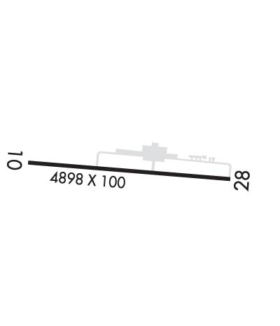
| 5001x100 | 4801' | 5001x100 | 4898' | 110.50 - 284° | ||||
| Runway ID | Single Wheel | Double Wheel | Double Tandem Wheel | Dual Double Wheel |
| 10/28 | 47,000 | 74,000 | N/A | N/A |
| These numbers are Advisory and are not limits. The Airport Manager should have more accurate Weight Limits | ||||
 Airport Diagram might not be current. | |
| Facility Name: | HAZLETON RGNL |
| City Name: | HAZLETON |
| County: | LUZERNE |
| State abbrev: | PA |
| State Name: | PENNSYLVANIA |
| Ownership: | PUBLICLY OWNED |
| Use: | OPEN TO THE PUBLIC |
| Owner's Name: | CITY OF HAZLETON |
| Address: | 40 N CHURCH ST |
| HAZLETON, PA 18201 | |
| Owner's Phone: | (570) 436-6676 |
| Manager's Name: | DAVE CHRONOWSKI |
| Address: | 5175 OLD AIRPORT RD |
| HAZLE TWP, PA 18202 | |
| Phone: | (484) 661-8994 |
| FAA Region: | EASTERN |
| FAA Field Office: | HAR |
| Date | Sunrise | Sunset |
|---|---|---|
| 09/24/21 Friday | 6:53 | 18:58 |
| 09/25/21 Saturday | 6:54 | 18:56 |
| 09/26/21 Sunday | 6:55 | 18:55 |
| 09/27/21 Monday | 6:56 | 18:53 |
| 09/28/21 Tuesday | 6:57 | 18:51 |
| 09/29/21 Wednesday | 6:58 | 18:50 |
| 09/30/21 Thursday | 6:59 | 18:48 |
| 10/01/21 Friday | 7:00 | 18:46 |
| 10/02/21 Saturday | 7:01 | 18:45 |
| 10/03/21 Sunday | 7:02 | 18:43 |
| 10/04/21 Monday | 7:03 | 18:41 |
| 10/05/21 Tuesday | 7:04 | 18:40 |
| 10/06/21 Wednesday | 7:05 | 18:38 |
| 10/07/21 Thursday | 7:07 | 18:36 |
| Airport Attendance Schedule | 7 Days A Week 0730-1600 |
| Airport Status | OPERATIONAL (This Status can change at any time - please check NOTAMS) |
| Airport Lighting Schedule | ACTVT MALS RWY 28; REIL RWY 10; PAPI RWY 10; MIRL RWY 10/28 (3,5,7 CLICKS) - CTAF. |
| Airport Storage Available | Tie Downs, Hanger |
| Extra Services Available | Air Ambulance, Parachute Jumping |
| Wind Indicator | YES - (lighted) |
| Control Tower | NO |
| CTAF Frequency | 123.000 |
| Unicom Frequency | 123.000 |
| Rotating Beacon Color | CLEAR-GREEN (Light Land Airport) |
| Segmented Circle | YES |
| Landing Fee | NO; JET, TURBOPROP AND CORPORATE AIRCRAFT ONLY. |
| Airport Inspected | STATE - performed by STATE AERONAUTICAL PERSONNEL |
| Inspection Date | 09/18/2020 |
| Type of Fuel Available | Grade 100LL, JET A (freeze point -40C); -10FUEL SVC AFT HRS BY PRIOR REQ 570-468-2479 OR 570-817-9698. |
| Airframe Repair Service | MINOR |
| Power Plant Repair Service | MINOR |
| Latitude | N4059.2 |
| Longitude | W07559.7 (ESTIMATED) |
| Arpt Elevation | 1603ft (SURVEYED) |
| Magnetic Variation | 10W |
| 2 miles NW | of HAZLETON |
| Traffic Pattern Altitude | |
| Sectional Chart | NEW YORK |
| Operations (Reported) | Yearly | Avg. Daily |
|---|---|---|
| General Aviation Transient | 9000 | 25 |
| General Aviation Local | 18000 | 49 |
| Air Taxi | 0 | 0 |
| Commerical | 0 | 0 |
| Commuter | 0 | 0 |
| Military | 100 | 0 |
| Aircraft based on Field | |
|---|---|
| General Aviation Singles | 44 |
| General Aviation Multi | 2 |
| Jet Aircraft | 3 |
| General Aviation Helicopters | 9 |
| Military Aircraft | 0 |
| Gliders | 0 |
| Ultralights | 0 |
| FSS on field | NO |
| FSS tie-in | WILLIAMSPORT |
| FSS Phone | 1-800-WX-BRIEF |
| Who issues Notams | IPT |
| Notam D service at airport | YES |
| ARTCC Name | NEW YORK |
| Airport Certification | |
| Aircraft Rescue & Firefighting Index | None |
| Airport of Entry | No |
| Custom Landing Rights | No |
| Joint Civil/Military | No |
| Military Landing rights | YES |
| NATIONAL PLAN OF INTEGRATED AIRPORT SYSTEMS (NPIAS) |
| GRANT AGREEMENTS UNDER FAAP/ADAP/AIP |
| ASSURANCES PURSUANT TO TITLE VI, CIVIL RIGHTS ACT OF 1964 |
| AWOS AVBL 570-459-4901. |
| TYPE 1 DEICING AVBL. |
Airport Communications & Frequencies:
| ||||||||||||||||
| Runway: 10 | Runway: 28 | ||
| Mag heading: | 104° | Mag heading: | 284° |
| Rwy Slope: | -.02% Down | Rwy Slope: | .02% Up |
| Approach: | Approach: | LOC/DME | |
| Pattern: | Left Traffic | Pattern: | Right Traffic; VFR DEP PROCEDURE RIGHT TURN HEADING 300 DEGS AT END OF RY. |
| Markings: | NONPRECISION INSTRUMENT | Markings: | NONPRECISION INSTRUMENT |
| Marking Condition: | GOOD | Marking Condition: | GOOD |
| Arresting Dev: | Arresting Dev: | ||
| Lat & Long: | N4059.2 W07600.2 | Lat. & Long.: | N4059.2 W07559.1 |
| Elev: | 1595.5 ft. MSL | Elev: | 1594.5 ft. MSL |
| TCH: | 46 ft. AGL | TCH: | 40 ft. AGL |
| Visual Glide Path: | 3.50 degrees | Visual Glide Path: | 3.17 degrees |
| Displaced Threshold: | 200 feet | Displaced Threshold: | 103 feet |
| Touchdown Zone: | YES | Touchdown Zone: | YES |
| Touchdown Elev.: | 1603.4 feet | Touchdown Elev.: | 1603.4 feet |
| Visual Glide Slope: | 4-Light PAPI on LEFT side of Runway | Visual Glide Slope: | 4-Light PAPI on LEFT side of Runway |
| RVR Equipment: | RVR Equipment: | ||
| RVV Equipment: | NO | RVV Equipment: | NO |
| Approach Lights: | Approach Lights: | MALS - 1,400 foot medium intensity approach lighting system | |
| REIL: | YES | REIL: | NO |
| Centerline Lights: | NO | Centerline Lights: | NO |
| Touchdown lights: | NO | Touchdown lights: | NO |
| Runway Category: | Runway with a Non-precision Approach having visibility minimums greater than 3/4 mile | Runway Category: | Runway with a Non-precision Approach having visibility minimums greater than 3/4 mile |
| Declared Distances: | TORA:5001' TODA:5001' ASDA:5001' LDA:4801' | Declared Distances: | TORA:5001' TODA:5001' ASDA:5001' LDA:4898' |
| Obstructions: | TREES | Obstructions: | TREE |
| Marked: | NOT Marked/Lighted | Marked: | NOT Marked/Lighted |
| Clearance slope: | 25:1; RWY 10 APCH SLP 27:1 TO 200 FT DTHR. | Clearance slope: | 22:1; RWY 28 APCH SLP 27:1 TO 103 FT DTHR. |
| Obstruction height: | 190 feet AGL | Obstruction height: | 56 feet AGL |
| Dist. from runway: | 4970 feet | Dist. from runway: | 1436 feet |
| Centerline offset: | 300 right of centerline | Centerline offset: | 411 feet left of centerline |
| Comments: | Comments: |
Thanks for using FltPlan.com
all rights reserved © 1999-2021 by Flight Plan LLC
