
| KIRSCH MUNI STURGIS MI |
| |
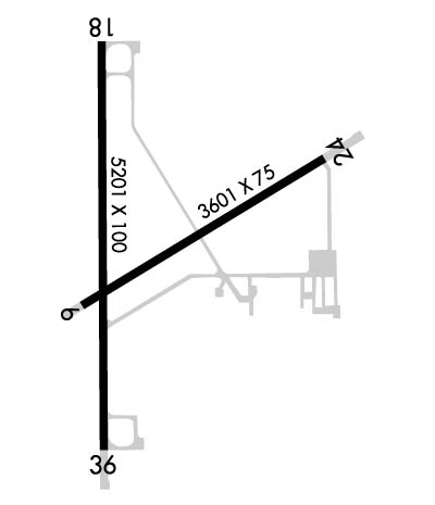
| Lat: N 4148.8 Long: W 08526.3 Elev: 925 Var: +04 Longest Runway: 5201 | ||
| Clr Del: 118.325 AWOS: 121.32 CTAF: 123.05 | ||
| ||||||
| ||||||
|
| Rwy | Rwy | |||||||
| 3601x75 | 3601' | 3601x75 | 3601' | |||||
| 5201x100 | 5201' | 5201x100 | 5201' | |||||
| Runway ID | Single Wheel | Double Wheel | Double Tandem Wheel | Dual Double Wheel |
| 06/24 | 19,000 | 25,000 | 58,000 | N/A |
| 18/36 | 47,000 | 57,500 | 90,000 | N/A |
| These numbers are Advisory and are not limits. The Airport Manager should have more accurate Weight Limits | ||||
 Airport Diagram might not be current. | |
| Facility Name: | KIRSCH MUNI |
| City Name: | STURGIS |
| County: | ST JOSEPH |
| State abbrev: | MI |
| State Name: | MICHIGAN |
| Ownership: | PUBLICLY OWNED |
| Use: | OPEN TO THE PUBLIC |
| Owner's Name: | CITY OF STURGIS |
| Address: | 130 N. NOTTAWA |
| STURGIS, MI 49091-1433 | |
| Owner's Phone: | 269-651-2321 |
| Manager's Name: | MICHAEL HUGHES, CITY/AIRPORT MGR; ARPT/CITY MGR 269-651-2321. ASST MGR/FBO BRIAN RILEY 269-651-2821. |
| Address: | 130 NORTH NOTTAWA, P O BOX 280 |
| STURGIS, MI 49091-1433 | |
| Phone: | (269) 651-2821 |
| FAA Region: | GREAT LAKES |
| FAA Field Office: | DET |
| Date | Sunrise | Sunset |
|---|---|---|
| 09/24/21 Friday | 7:31 | 19:36 |
| 09/25/21 Saturday | 7:32 | 19:34 |
| 09/26/21 Sunday | 7:33 | 19:32 |
| 09/27/21 Monday | 7:34 | 19:31 |
| 09/28/21 Tuesday | 7:35 | 19:29 |
| 09/29/21 Wednesday | 7:36 | 19:27 |
| 09/30/21 Thursday | 7:37 | 19:26 |
| 10/01/21 Friday | 7:38 | 19:24 |
| 10/02/21 Saturday | 7:39 | 19:22 |
| 10/03/21 Sunday | 7:41 | 19:20 |
| 10/04/21 Monday | 7:42 | 19:19 |
| 10/05/21 Tuesday | 7:43 | 19:17 |
| 10/06/21 Wednesday | 7:44 | 19:15 |
| 10/07/21 Thursday | 7:45 | 19:14 |
| Airport Attendance Schedule | MON-FRI 0800-1700 |
| Airport Status | OPERATIONAL (This Status can change at any time - please check NOTAMS) |
| Airport Lighting Schedule | ACTVT MIRL RYS 06/24 & 18/36, REIL RYS 24 ,18, & 36, PAPI RYS 24, 18, & 36 - CTAF. |
| Airport Storage Available | Tie Downs, Hanger |
| Extra Services Available | Charter, Aircraft Sales |
| Wind Indicator | YES - (lighted) |
| Control Tower | NO |
| CTAF Frequency | 123.050 |
| Unicom Frequency | 123.050 |
| Rotating Beacon Color | CLEAR-GREEN (Light Land Airport) |
| Segmented Circle | NO |
| Landing Fee | NO |
| Airport Inspected | STATE - performed by STATE AERONAUTICAL PERSONNEL |
| Inspection Date | 09/18/2019 |
| Type of Fuel Available | Grade 100LL, JET A-1 (icing inhibitor, freeze point -50C) |
| Airframe Repair Service | MAJOR |
| Power Plant Repair Service | MAJOR |
| Latitude | N4148.8 |
| Longitude | W08526.3 (ESTIMATED) |
| Arpt Elevation | 924ft (SURVEYED) |
| Magnetic Variation | 04W |
| 2 miles NW | of STURGIS |
| Traffic Pattern Altitude | |
| Sectional Chart | CHICAGO |
| Operations (Reported) | Yearly | Avg. Daily |
|---|---|---|
| General Aviation Transient | 6000 | 16 |
| General Aviation Local | 2000 | 5 |
| Air Taxi | 0 | 0 |
| Commerical | 0 | 0 |
| Commuter | 0 | 0 |
| Military | 0 | 0 |
| Aircraft based on Field | |
|---|---|
| General Aviation Singles | 15 |
| General Aviation Multi | 0 |
| Jet Aircraft | 0 |
| General Aviation Helicopters | 0 |
| Military Aircraft | 0 |
| Gliders | 0 |
| Ultralights | 0 |
| FSS on field | NO |
| FSS tie-in | LANSING |
| FSS Phone | 1-800-WX-BRIEF |
| Who issues Notams | IRS |
| Notam D service at airport | YES |
| ARTCC Name | CHICAGO |
| Airport Certification | |
| Aircraft Rescue & Firefighting Index | None |
| Airport of Entry | No |
| Custom Landing Rights | No |
| Joint Civil/Military | No |
| Military Landing rights | YES |
| NATIONAL PLAN OF INTEGRATED AIRPORT SYSTEMS (NPIAS) |
| GRANT AGREEMENTS UNDER FAAP/ADAP/AIP |
| ASSURANCES PURSUANT TO TITLE VI, CIVIL RIGHTS ACT OF 1964 |
| FOR CD WHEN GREAT LAKES APCH CLSD CTC CHICAGO ARTCC AT 630-906-8921. |
| CALL FOR SNOW REMOVAL INFO & RWY COND RPRT. |
| DEER AND BIRDS ON & INVOF RWYS. |
Airport Communications & Frequencies:
| |||||||||||||||||||
| Runway: 06 | Runway: 24 | ||
| Mag heading: | 63° | Mag heading: | 243° |
| Rwy Slope: | .35% Up | Rwy Slope: | -.35% Down |
| Approach: | Approach: | ||
| Pattern: | Left Traffic | Pattern: | Left Traffic |
| Markings: | BASIC | Markings: | BASIC |
| Marking Condition: | GOOD | Marking Condition: | GOOD |
| Arresting Dev: | Arresting Dev: | ||
| Lat & Long: | N4148.7 W08526.5 | Lat. & Long.: | N4149.0 W08525.8 |
| Elev: | 912.2 ft. MSL | Elev: | 924.8 ft. MSL |
| TCH: | TCH: | 22 ft. AGL | |
| Visual Glide Path: | Visual Glide Path: | 4.00 degrees | |
| Displaced Threshold: | No | Displaced Threshold: | No |
| Touchdown Zone: | YES | Touchdown Zone: | YES |
| Touchdown Elev.: | 923.3 feet | Touchdown Elev.: | 924.8 feet |
| Visual Glide Slope: | Visual Glide Slope: | 2-Light PAPI on LEFT side of Runway | |
| RVR Equipment: | RVR Equipment: | ||
| RVV Equipment: | NO | RVV Equipment: | NO |
| Approach Lights: | Approach Lights: | ||
| REIL: | NO | REIL: | YES |
| Centerline Lights: | NO | Centerline Lights: | NO |
| Touchdown lights: | NO | Touchdown lights: | NO |
| Runway Category: | Runway with a Visual Approach | Runway Category: | Runway with a Non-precision Approach |
| Declared Distances: | Declared Distances: | ||
| Obstructions: | TREES | Obstructions: | TREES |
| Marked: | NOT Marked/Lighted | Marked: | NOT Marked/Lighted |
| Clearance slope: | 23:1 | Clearance slope: | 20:1 |
| Obstruction height: | 74 feet AGL | Obstruction height: | 55 feet AGL |
| Dist. from runway: | 1960 feet | Dist. from runway: | 1300 feet |
| Centerline offset: | 125 right of centerline | Centerline offset: | 120 feet right of centerline |
| Comments: | Comments: |
| Runway: 18 | Runway: 36 | ||
| Mag heading: | 184° | Mag heading: | 4° |
| Rwy Slope: | .07% Up | Rwy Slope: | -.07% Down |
| Approach: | Approach: | ||
| Pattern: | Left Traffic | Pattern: | Left Traffic |
| Markings: | NONPRECISION INSTRUMENT | Markings: | NONPRECISION INSTRUMENT |
| Marking Condition: | GOOD | Marking Condition: | GOOD |
| Arresting Dev: | Arresting Dev: | ||
| Lat & Long: | N4149.2 W08526.5 | Lat. & Long.: | N4148.4 W08526.4 |
| Elev: | 908.2 ft. MSL | Elev: | 912.0 ft. MSL |
| TCH: | 27 ft. AGL | TCH: | 26 ft. AGL |
| Visual Glide Path: | 3.00 degrees | Visual Glide Path: | 3.00 degrees |
| Displaced Threshold: | No | Displaced Threshold: | No |
| Touchdown Zone: | YES | Touchdown Zone: | YES |
| Touchdown Elev.: | 914.5 feet | Touchdown Elev.: | 914.8 feet |
| Visual Glide Slope: | 4-Light PAPI on LEFT side of Runway | Visual Glide Slope: | 4-Light PAPI on LEFT side of Runway |
| RVR Equipment: | RVR Equipment: | ||
| RVV Equipment: | NO | RVV Equipment: | NO |
| Approach Lights: | Approach Lights: | ||
| REIL: | YES | REIL: | YES |
| Centerline Lights: | NO | Centerline Lights: | NO |
| Touchdown lights: | NO | Touchdown lights: | NO |
| Runway Category: | Runway with a Non-precision Approach having visibility minimums greater than 3/4 mile | Runway Category: | Runway with a Visual Approach |
| Declared Distances: | Declared Distances: | ||
| Obstructions: | TREES | Obstructions: | TREES |
| Marked: | NOT Marked/Lighted | Marked: | NOT Marked/Lighted |
| Clearance slope: | 24:1 | Clearance slope: | 30:1 |
| Obstruction height: | 133 feet AGL | Obstruction height: | 60 feet AGL |
| Dist. from runway: | 3427 feet | Dist. from runway: | 2020 feet |
| Centerline offset: | Centerline offset: | 106 feet right of centerline | |
| Comments: | Comments: |
Thanks for using FltPlan.com
all rights reserved © 1999-2021 by Flight Plan LLC
