
| LAWRENCEBURG-LAWRENCE COUNTY LAWRENCEBURG TN |
| |
| Lat: N 3514.1 Long: W 08715.5 Elev: 937 Var: +01 Longest Runway: 5002 | ||
| Clr Del: 121.72 (GCO) AWOS: 120.17 CTAF: 122.8 | ||
| ||||||||||||||||||||||||||||||||||||||||||||
| ||||||||||||||||||||||||||||||||||||||||||||
| ||||||||||||||||||||||||||||||||||||||||||||
| Rwy | Rwy | |||||||
| 5002x100 | 5002' | 5002x100 | 5002' | |||||
| Runway ID | Single Wheel | Double Wheel | Double Tandem Wheel | Dual Double Wheel |
| 17/35 | 33,500 | 50,000 | N/A | N/A |
| These numbers are Advisory and are not limits. The Airport Manager should have more accurate Weight Limits | ||||
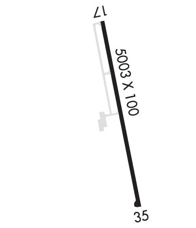 Airport Diagram might not be current. | |
| Facility Name: | LAWRENCEBURG/LAWRENCE COUNTY (FLEEMAN FLD) |
| City Name: | LAWRENCEBURG |
| County: | LAWRENCE |
| State abbrev: | TN |
| State Name: | TENNESSEE |
| Ownership: | PUBLICLY OWNED |
| Use: | OPEN TO THE PUBLIC |
| Owner's Name: | CITY OF LAWRENCEBURG |
| Address: | 233 WEST GAINES |
| LAWRENCEBURG, TN 38464 | |
| Owner's Phone: | 931-762-5133; 931-766-4128. |
| Manager's Name: | DOUG SMITH |
| Address: | 4110 AIRPORT DR |
| LAWRENCEBURG, TN 38464 | |
| Phone: | 931-762-5133 |
| FAA Region: | SOUTHERN |
| FAA Field Office: | MEM |
| Date | Sunrise | Sunset |
|---|---|---|
| 04/26/25 Saturday | 6:04 | 19:31 |
| 04/27/25 Sunday | 6:02 | 19:31 |
| 04/28/25 Monday | 6:01 | 19:32 |
| 04/29/25 Tuesday | 6:00 | 19:33 |
| 04/30/25 Wednesday | 5:59 | 19:34 |
| 05/01/25 Thursday | 5:58 | 19:35 |
| 05/02/25 Friday | 5:57 | 19:36 |
| 05/03/25 Saturday | 5:56 | 19:36 |
| 05/04/25 Sunday | 5:55 | 19:37 |
| 05/05/25 Monday | 5:54 | 19:38 |
| 05/06/25 Tuesday | 5:53 | 19:39 |
| 05/07/25 Wednesday | 5:52 | 19:40 |
| 05/08/25 Thursday | 5:51 | 19:40 |
| 05/09/25 Friday | 5:50 | 19:41 |
| Airport Attendance Schedule | 7 Days A Week 0800-1700; AFT HR - 931-231-4075. |
| Airport Status | OPERATIONAL (This Status can change at any time - please check NOTAMS) |
| Airport Lighting Schedule | SS-SR |
| Airport Storage Available | Tie Downs, Hanger |
| Extra Services Available | Crop Dusting, Flight Instruction |
| Wind Indicator | YES - (lighted) |
| Control Tower | NO |
| CTAF Frequency | 122.800 |
| Unicom Frequency | 122.800 |
| Rotating Beacon Color | WG |
| Segmented Circle | YES |
| Landing Fee | NO |
| Airport Inspected | STATE - performed by STATE AERONAUTICAL PERSONNEL |
| Inspection Date | 04/24/2023 |
| Type of Fuel Available | Grade 100LL, JET A |
| Airframe Repair Service | MAJOR; BOTH ON SITE |
| Power Plant Repair Service | MINOR |
| Latitude | N3514.1 |
| Longitude | W08715.5 (ESTIMATED) |
| Arpt Elevation | 936ft (SURVEYED) |
| Magnetic Variation | 01W |
| 3 miles NE | of LAWRENCEBURG |
| Traffic Pattern Altitude | |
| Sectional Chart | ATLANTA |
| Operations (Reported) | Yearly | Avg. Daily |
|---|---|---|
| General Aviation Transient | 0 | 0 |
| General Aviation Local | 0 | 0 |
| Air Taxi | 0 | 0 |
| Commerical | 0 | 0 |
| Commuter | 0 | 0 |
| Military | 0 | 0 |
| Aircraft based on Field | |
|---|---|
| General Aviation Singles | 0 |
| General Aviation Multi | 0 |
| Jet Aircraft | 0 |
| General Aviation Helicopters | 0 |
| Military Aircraft | 0 |
| Gliders | 0 |
| Ultralights | 0 |
| FSS on field | NO |
| FSS tie-in | JACKSON |
| FSS Phone | 1-800-WX-BRIEF |
| Who issues Notams | MKL |
| Notam D service at airport | YES |
| ARTCC Name | MEMPHIS |
| Airport Certification | |
| Aircraft Rescue & Firefighting Index | None |
| Airport of Entry | No |
| Custom Landing Rights | No |
| Joint Civil/Military | No |
| Military Landing rights | YES |
| NATIONAL PLAN OF INTEGRATED AIRPORT SYSTEMS (NPIAS) |
| GRANT AGREEMENT HAS EXPIRED; HOWEVER, AGREEMENT REMAINS IN EFFECT FOR THIS FACILITY AS LONG AS IT IS PUBLIC USE. |
| FOR CD CTC MEMPHIS ARTCC AT 901-368-8453/8449. |
Airport Communications & Frequencies:
| |||||||||
| Runway: 17 | Runway: 35 | ||
| Mag heading: | 168° | Mag heading: | 348° |
| Rwy Slope: | -.18% Down | Rwy Slope: | .18% Up |
| Approach: | Approach: | ||
| Pattern: | Left Traffic | Pattern: | Left Traffic |
| Markings: | NONPRECISION INSTRUMENT | Markings: | NONPRECISION INSTRUMENT |
| Marking Condition: | FAIR | Marking Condition: | FAIR |
| Arresting Dev: | Arresting Dev: | ||
| Lat & Long: | N3514.5 W08715.6 | Lat. & Long.: | N3513.7 W08715.4 |
| Elev: | 936.5 ft. MSL | Elev: | 927.3 ft. MSL |
| TCH: | 25 ft. AGL | TCH: | 24 ft. AGL |
| Visual Glide Path: | 3.00 degrees | Visual Glide Path: | 3.00 degrees |
| Displaced Threshold: | No | Displaced Threshold: | No |
| Touchdown Zone: | YES | Touchdown Zone: | YES |
| Touchdown Elev.: | 936.5 feet | Touchdown Elev.: | 927.3 feet |
| Visual Glide Slope: | 4-Light PAPI on LEFT side of Runway | Visual Glide Slope: | 4-Light PAPI on LEFT side of Runway |
| RVR Equipment: | RVR Equipment: | ||
| RVV Equipment: | NO | RVV Equipment: | NO |
| Approach Lights: | Approach Lights: | ||
| REIL: | YES | REIL: | YES |
| Centerline Lights: | NO | Centerline Lights: | NO |
| Touchdown lights: | NO | Touchdown lights: | NO |
| Runway Category: | Runway with a Non-precision Approach having visibility minimums greater than 3/4 mile | Runway Category: | Runway with a Non-precision Approach having visibility minimums greater than 3/4 mile |
| Declared Distances: | Declared Distances: | ||
| Obstructions: | TREES | Obstructions: | TREES |
| Marked: | NOT Marked/Lighted | Marked: | NOT Marked/Lighted |
| Clearance slope: | 15:1 | Clearance slope: | 24:1 |
| Obstruction height: | 99 feet AGL | Obstruction height: | 113 feet AGL |
| Dist. from runway: | 1732 feet | Dist. from runway: | 2818 feet |
| Centerline offset: | 127 left of centerline | Centerline offset: | 167 feet left of centerline |
| Comments: | Comments: |
Thanks for using FltPlan.com
all rights reserved © 1999-2025 by Flight Plan LLC
