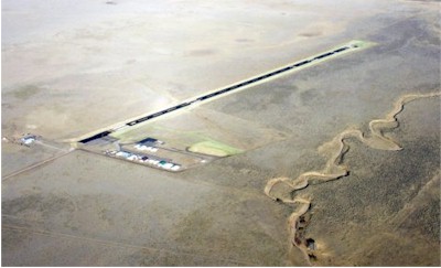
| SPANISH PEAKS AIRFIELD WALSENBURG CO |
| |
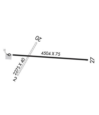
| Lat: N 3741.8 Long: W 10447.1 Elev: 6055 Var: -08 Longest Runway: 4715 | ||
| AWOS: 123.6 CTAF: 122.8 | ||
| ||||||
| ||||||
|
| Rwy | Rwy | |||||||
| 2238x40 | 2238' | 2238x40 | 2238' | |||||
| 4715x75 | 4505' | 4715x75 | 4715' | |||||
| Runway ID | Single Wheel | Double Wheel | Double Tandem Wheel | Dual Double Wheel |
| 02/20 | N/A | N/A | N/A | N/A |
| 09/27 | 17,000 | 17,000 | N/A | N/A |
| These numbers are Advisory and are not limits. The Airport Manager should have more accurate Weight Limits | ||||
 Airport Diagram might not be current. | |
| Facility Name: | SPANISH PEAKS AIRFIELD |
| City Name: | WALSENBURG |
| County: | HUERFANO |
| State abbrev: | CO |
| State Name: | COLORADO |
| Ownership: | PUBLICLY OWNED |
| Use: | OPEN TO THE PUBLIC |
| Owner's Name: | HUERFANO COUNTY |
| Address: | COUNTY COURTHOUSE |
| WALSENBURG, CO 81089 | |
| Owner's Phone: | 719-738-2370 |
| Manager's Name: | DUSTIN HRIBAR |
| Address: | 401 MAIN ST |
| WALSENBURG, CO 81089 | |
| Phone: | 719-989-0376 |
| FAA Region: | NORTHWEST MOUNTAIN |
| FAA Field Office: | DEN |
| Date | Sunrise | Sunset |
|---|---|---|
| 04/17/25 Thursday | 6:22 | 19:36 |
| 04/18/25 Friday | 6:20 | 19:37 |
| 04/19/25 Saturday | 6:19 | 19:38 |
| 04/20/25 Sunday | 6:18 | 19:39 |
| 04/21/25 Monday | 6:16 | 19:40 |
| 04/22/25 Tuesday | 6:15 | 19:41 |
| 04/23/25 Wednesday | 6:14 | 19:42 |
| 04/24/25 Thursday | 6:12 | 19:43 |
| 04/25/25 Friday | 6:11 | 19:44 |
| 04/26/25 Saturday | 6:10 | 19:45 |
| 04/27/25 Sunday | 6:09 | 19:46 |
| 04/28/25 Monday | 6:07 | 19:47 |
| 04/29/25 Tuesday | 6:06 | 19:47 |
| 04/30/25 Wednesday | 6:05 | 19:48 |
| Airport Attendance Schedule | IRREGULAR |
| Airport Status | OPERATIONAL (This Status can change at any time - please check NOTAMS) |
| Airport Lighting Schedule | ACTVT PAPI RWY 09 & 27; MIRL RWY 09/27 - CTAF. |
| Airport Storage Available | Tie Downs |
| Extra Services Available | Flight Instruction, Aircraft Rental |
| Wind Indicator | YES - (lighted) |
| Control Tower | NO |
| CTAF Frequency | 122.800 |
| Unicom Frequency | 122.800 |
| Rotating Beacon Color | |
| Segmented Circle | NO |
| Landing Fee | NO |
| Airport Inspected | STATE - performed by STATE AERONAUTICAL PERSONNEL |
| Inspection Date | 04/17/2023 |
| Type of Fuel Available | Grade 100LL, JET A (freeze point -40C); -1024 HR CREDIT CARD FUEL AVBL. |
| Airframe Repair Service | None |
| Power Plant Repair Service | None |
| Latitude | N3741.8 |
| Longitude | W10447.1 (ESTIMATED) |
| Arpt Elevation | 6054ft (SURVEYED) |
| Magnetic Variation | 08E |
| 5 miles N | of WALSENBURG |
| Traffic Pattern Altitude | |
| Sectional Chart | DENVER |
| Operations (Reported) | Yearly | Avg. Daily |
|---|---|---|
| General Aviation Transient | 0 | 0 |
| General Aviation Local | 0 | 0 |
| Air Taxi | 0 | 0 |
| Commerical | 0 | 0 |
| Commuter | 0 | 0 |
| Military | 0 | 0 |
| Aircraft based on Field | |
|---|---|
| General Aviation Singles | 0 |
| General Aviation Multi | 0 |
| Jet Aircraft | 0 |
| General Aviation Helicopters | 0 |
| Military Aircraft | 0 |
| Gliders | 0 |
| Ultralights | 0 |
| FSS on field | NO |
| FSS tie-in | DENVER |
| FSS Phone | 1-800-WX-BRIEF |
| Who issues Notams | DEN |
| Notam D service at airport | YES |
| ARTCC Name | DENVER |
| Airport Certification | |
| Aircraft Rescue & Firefighting Index | None |
| Airport of Entry | No |
| Custom Landing Rights | No |
| Joint Civil/Military | No |
| Military Landing rights | No |
| NATIONAL PLAN OF INTEGRATED AIRPORT SYSTEMS (NPIAS) |
| BE ALERT: INTENSIVE USAF STUDENT TRNG ACT INVOF COLORADO SPRINGS & PUEBLO, CO. |
| FOR CD CTC DENVER ARTCC AT 303-651-4257. |
| RWY 02/2 0 RWY 02/20 CLSD EXCP PPR CTC AMGR PRIOR TO USE 719-742-5323 OR 719-859-5323. |
| RWY 02/2 0 RWY 02 ROUGH AND NOT WELL MAINTAINED. |
| RWY 02/2 0 1RWY 02 FIRST 1000 FT HAS RUTS AND BUMPS. |
Airport Communications & Frequencies:
| |||||||||
| Runway: 02 | Runway: 20 | ||
| Mag heading: | 23° | Mag heading: | 203° |
| Rwy Slope: | -.97% Down | Rwy Slope: | .97% Up |
| Approach: | Approach: | ||
| Pattern: | Left Traffic | Pattern: | Left Traffic |
| Markings: | NONSTANDARD | Markings: | NONSTANDARD |
| Marking Condition: | FAIR | Marking Condition: | FAIR |
| Arresting Dev: | Arresting Dev: | ||
| Lat & Long: | N3741.6 W10447.4 | Lat. & Long.: | N3741.9 W10447.2 |
| Elev: | 6054.7 ft. MSL | Elev: | 6033.0 ft. MSL |
| TCH: | TCH: | ||
| Visual Glide Path: | Visual Glide Path: | ||
| Displaced Threshold: | No | Displaced Threshold: | No |
| Touchdown Zone: | YES | Touchdown Zone: | YES |
| Touchdown Elev.: | 6050.6 feet | Touchdown Elev.: | 6050.6 feet |
| Visual Glide Slope: | Visual Glide Slope: | ||
| RVR Equipment: | RVR Equipment: | ||
| RVV Equipment: | NO | RVV Equipment: | NO |
| Approach Lights: | Approach Lights: | ||
| REIL: | NO | REIL: | NO |
| Centerline Lights: | NO | Centerline Lights: | NO |
| Touchdown lights: | NO | Touchdown lights: | NO |
| Runway Category: | Runway with a Visual Approach | Runway Category: | Runway with a Visual Approach |
| Declared Distances: | TORA:2012' TODA:2012' ASDA:2012' LDA:2012' | Declared Distances: | TORA:2012' TODA:2012' ASDA:2012' LDA:2012' |
| Obstructions: | FENCE | Obstructions: | |
| Marked: | NOT Marked/Lighted | Marked: | |
| Clearance slope: | 16:1 | Clearance slope: | 50:1 |
| Obstruction height: | 12 feet AGL | Obstruction height: | |
| Dist. from runway: | 200 feet | Dist. from runway: | |
| Centerline offset: | Centerline offset: | ||
| Comments: | RWY 02 5 FT FENCE AT THLD BOTH SIDES OF CNTRLN. | Comments: | RWY 20 4 FT FENCE 240 FT FM THLD BOTH SIDES OF CNTRLN. |
| Runway: 09 | Runway: 27 | ||
| Mag heading: | 85° | Mag heading: | 265° |
| Rwy Slope: | -.59% Down | Rwy Slope: | .59% Up |
| Approach: | Approach: | ||
| Pattern: | Left Traffic | Pattern: | Left Traffic |
| Markings: | NONPRECISION INSTRUMENT | Markings: | NONPRECISION INSTRUMENT |
| Marking Condition: | GOOD | Marking Condition: | GOOD |
| Arresting Dev: | Arresting Dev: | ||
| Lat & Long: | N3741.8 W10447.5 | Lat. & Long.: | N3741.8 W10446.5 |
| Elev: | 6046.9 ft. MSL | Elev: | 6019.1 ft. MSL |
| TCH: | 45 ft. AGL | TCH: | 45 ft. AGL |
| Visual Glide Path: | 3.00 degrees | Visual Glide Path: | 3.00 degrees |
| Displaced Threshold: | 210 feet | Displaced Threshold: | No |
| Touchdown Zone: | YES | Touchdown Zone: | YES |
| Touchdown Elev.: | 6047.0 feet | Touchdown Elev.: | 6036.8 feet |
| Visual Glide Slope: | 2-Light PAPI on LEFT side of Runway | Visual Glide Slope: | 2-Light PAPI on LEFT side of Runway |
| RVR Equipment: | RVR Equipment: | ||
| RVV Equipment: | NO | RVV Equipment: | NO |
| Approach Lights: | Approach Lights: | ||
| REIL: | NO | REIL: | NO |
| Centerline Lights: | NO | Centerline Lights: | NO |
| Touchdown lights: | NO | Touchdown lights: | NO |
| Runway Category: | Runway with a Visual Approach | Runway Category: | Runway with a Visual Approach |
| Declared Distances: | TORA:4502' TODA:4502' ASDA:4502' LDA:4502' | Declared Distances: | TORA:4712' TODA:4712' ASDA:4712' LDA:4712' |
Thanks for using FltPlan.com
all rights reserved © 1999-2025 by Flight Plan LLC