
| LENAWEE COUNTY ADRIAN MI |
| |
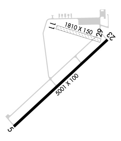
| Lat: N 4152.1 Long: W 08404.6 Elev: 798 Var: +06 Longest Runway: 5001 | ||
| AWOS: 118.37 CTAF: 122.8 | ||
| ||||||
| ||||||
|
| Rwy | Rwy | |||||||
| 5001x100 | 5001' | 5001x100 | 5001' | |||||
| 1810x150 | 1810' | 1810x150 | 1810' | |||||
| Runway ID | Single Wheel | Double Wheel | Double Tandem Wheel | Dual Double Wheel |
| 05/23 | 20,000 | N/A | N/A | N/A |
| 11/29 | N/A | N/A | N/A | N/A |
| These numbers are Advisory and are not limits. The Airport Manager should have more accurate Weight Limits | ||||
 Airport Diagram might not be current. | |
| Facility Name: | LENAWEE COUNTY |
| City Name: | ADRIAN |
| County: | LENAWEE |
| State abbrev: | MI |
| State Name: | MICHIGAN |
| Ownership: | PUBLICLY OWNED |
| Use: | OPEN TO THE PUBLIC |
| Owner's Name: | LENAWEE COUNTY |
| Address: | 301 N. MAIN ST. |
| ADRIAN, MI 49221 | |
| Owner's Phone: | 517-265-2827 |
| Manager's Name: | JOSEPH MALAK |
| Address: | 2651 CADMUS RD |
| ADRIAN, MI 49221 | |
| Phone: | (517) 265-8993; AFTER HOURS 517-673-4252 |
| FAA Region: | GREAT LAKES |
| FAA Field Office: | DET |
| Date | Sunrise | Sunset |
|---|---|---|
| 09/24/21 Friday | 7:26 | 19:30 |
| 09/25/21 Saturday | 7:27 | 19:29 |
| 09/26/21 Sunday | 7:28 | 19:27 |
| 09/27/21 Monday | 7:29 | 19:25 |
| 09/28/21 Tuesday | 7:30 | 19:24 |
| 09/29/21 Wednesday | 7:31 | 19:22 |
| 09/30/21 Thursday | 7:32 | 19:20 |
| 10/01/21 Friday | 7:33 | 19:18 |
| 10/02/21 Saturday | 7:34 | 19:17 |
| 10/03/21 Sunday | 7:35 | 19:15 |
| 10/04/21 Monday | 7:36 | 19:13 |
| 10/05/21 Tuesday | 7:37 | 19:12 |
| 10/06/21 Wednesday | 7:38 | 19:10 |
| 10/07/21 Thursday | 7:39 | 19:08 |
| Airport Attendance Schedule | M-F 0800-DUSK, SAT 0800-1200; UNATNDD MAJOR HOLS. |
| Airport Status | OPERATIONAL (This Status can change at any time - please check NOTAMS) |
| Airport Lighting Schedule | HIRL RY 05/23 PRESET LOW INTST; TO INCR INTST & ACTVT REIL RY 05; PAPI RY 05/23; HIRL RY 05/23 - CTAF. |
| Airport Storage Available | Tie Downs |
| Extra Services Available | Charter, Glider, Flight Instruction, Aircraft Sales |
| Wind Indicator | YES - (lighted) |
| Control Tower | NO |
| CTAF Frequency | 122.800 |
| Unicom Frequency | 122.800 |
| Rotating Beacon Color | CLEAR-GREEN (Light Land Airport) |
| Segmented Circle | YES |
| Landing Fee | NO |
| Airport Inspected | STATE - performed by STATE AERONAUTICAL PERSONNEL |
| Inspection Date | 06/04/2018 |
| Type of Fuel Available | Grade 100LL, JET A (freeze point -40C); -1024 HR SELF SERVE FUEL (100 LL ONLY) WITH CREDIT CARD. |
| Airframe Repair Service | MAJOR |
| Power Plant Repair Service | MAJOR |
| Latitude | N4152.1 |
| Longitude | W08404.6 (ESTIMATED) |
| Arpt Elevation | 798ft (SURVEYED) |
| Magnetic Variation | 06W |
| 3 miles SW | of ADRIAN |
| Traffic Pattern Altitude | |
| Sectional Chart | DETROIT |
| Operations (Reported) | Yearly | Avg. Daily |
|---|---|---|
| General Aviation Transient | 6000 | 16 |
| General Aviation Local | 12000 | 33 |
| Air Taxi | 0 | 0 |
| Commerical | 0 | 0 |
| Commuter | 0 | 0 |
| Military | 0 | 0 |
| Aircraft based on Field | |
|---|---|
| General Aviation Singles | 45 |
| General Aviation Multi | 2 |
| Jet Aircraft | 0 |
| General Aviation Helicopters | 1 |
| Military Aircraft | 0 |
| Gliders | 11 |
| Ultralights | 0 |
| FSS on field | NO |
| FSS tie-in | LANSING |
| FSS Phone | 1-800-WX-BRIEF |
| Who issues Notams | ADG |
| Notam D service at airport | YES |
| ARTCC Name | CLEVELAND |
| Airport Certification | |
| Aircraft Rescue & Firefighting Index | None |
| Airport of Entry | No |
| Custom Landing Rights | No |
| Joint Civil/Military | No |
| Military Landing rights | YES |
| NATIONAL PLAN OF INTEGRATED AIRPORT SYSTEMS (NPIAS) |
| GRANT AGREEMENTS UNDER FAAP/ADAP/AIP |
| ASSURANCES PURSUANT TO TITLE VI, CIVIL RIGHTS ACT OF 1964 |
| SNOW REMOVAL RWY 05/23 & TWYS ONLY. |
| TAXI ON HARD SFCS ONLY DURG SPRING THAW & WET CONDTIONS. |
| EXTSV GLDR OPS APR-OCT. |
| LANDING FEE FOR COMM A/C - WAIVED W/FUEL PURCHASE. |
| CTC CG OPS ON 156.8/381.8/2182.0/2687.0/5696.0. |
| FOR CD CTC TOLEDO APCH AT 419-865-1495 |
| RWY 11/2 9 CLSD DEC-APR & WHEN SN COVD, EXC FOR SKI EQUIPPED ACFT. NO SN REMOVAL. |
Airport Communications & Frequencies:
| ||||||||||||||
| Runway: 05 | Runway: 23 | ||
| Mag heading: | 53° | Mag heading: | 233° |
| Rwy Slope: | .08% Up | Rwy Slope: | -.08% Down |
| Approach: | Approach: | ||
| Pattern: | Left Traffic | Pattern: | Left Traffic |
| Markings: | NONPRECISION INSTRUMENT | Markings: | NONPRECISION INSTRUMENT |
| Marking Condition: | FAIR | Marking Condition: | FAIR |
| Arresting Dev: | Arresting Dev: | ||
| Lat & Long: | N4151.7 W08405.1 | Lat. & Long.: | N4152.3 W08404.3 |
| Elev: | 793.8 ft. MSL | Elev: | 798.0 ft. MSL |
| TCH: | 32 ft. AGL | TCH: | 32 ft. AGL |
| Visual Glide Path: | 3.00 degrees | Visual Glide Path: | 3.00 degrees |
| Displaced Threshold: | No | Displaced Threshold: | No |
| Touchdown Zone: | YES | Touchdown Zone: | YES |
| Touchdown Elev.: | 798.2 feet | Touchdown Elev.: | 798.2 feet |
| Visual Glide Slope: | 4-Light PAPI on LEFT side of Runway | Visual Glide Slope: | 4-Light PAPI on LEFT side of Runway |
| RVR Equipment: | RVR Equipment: | ||
| RVV Equipment: | NO | RVV Equipment: | NO |
| Approach Lights: | Approach Lights: | ||
| REIL: | YES | REIL: | NO |
| Centerline Lights: | NO | Centerline Lights: | NO |
| Touchdown lights: | NO | Touchdown lights: | NO |
| Runway Category: | D | Runway Category: | Runway with a Non-precision Approach having visibility minimums greater than 3/4 mile |
| Declared Distances: | Declared Distances: | ||
| Obstructions: | TREES | Obstructions: | TREES |
| Marked: | NOT Marked/Lighted | Marked: | NOT Marked/Lighted |
| Clearance slope: | 27:1 | Clearance slope: | 20:1 |
| Obstruction height: | 62 feet AGL | Obstruction height: | 52 feet AGL |
| Dist. from runway: | 1900 feet | Dist. from runway: | 1280 feet |
| Centerline offset: | Centerline offset: | 590 feet right of centerline | |
| Comments: | Comments: |
| Runway: 11 | Runway: 29 | ||
| Mag heading: | 113° | Mag heading: | 293° |
| Rwy Slope: | -.06% Down | Rwy Slope: | .06% Up |
| Approach: | Approach: | ||
| Pattern: | Left Traffic | Pattern: | Left Traffic |
| Markings: | Markings: | ||
| Marking Condition: | 11/29 MKD WITH 3 FT YELLOW CONES. | Marking Condition: | |
| Arresting Dev: | Arresting Dev: | ||
| Lat & Long: | N4152.3 W08404.7 | Lat. & Long.: | N4152.3 W08404.3 |
| Elev: | 798.0 ft. MSL | Elev: | 797.0 ft. MSL |
| TCH: | TCH: | ||
| Visual Glide Path: | Visual Glide Path: | ||
| Displaced Threshold: | No | Displaced Threshold: | No |
| Touchdown Zone: | NO | Touchdown Zone: | NO |
| Touchdown Elev.: | Touchdown Elev.: | ||
| Visual Glide Slope: | Visual Glide Slope: | ||
| RVR Equipment: | RVR Equipment: | ||
| RVV Equipment: | NO | RVV Equipment: | NO |
| Approach Lights: | Approach Lights: | ||
| REIL: | NO | REIL: | NO |
| Centerline Lights: | NO | Centerline Lights: | NO |
| Touchdown lights: | NO | Touchdown lights: | NO |
| Runway Category: | Runway with a Visual Approach | Runway Category: | Runway with a Visual Approach |
| Declared Distances: | Declared Distances: | ||
| Obstructions: | TREES | Obstructions: | TREES |
| Marked: | NOT Marked/Lighted | Marked: | NOT Marked/Lighted |
| Clearance slope: | 20:1 | Clearance slope: | 25:1 |
| Obstruction height: | 100 feet AGL | Obstruction height: | 46 feet AGL |
| Dist. from runway: | 2000 feet | Dist. from runway: | 1150 feet |
| Centerline offset: | Centerline offset: | ||
| Comments: | Comments: |
Thanks for using FltPlan.com
all rights reserved © 1999-2021 by Flight Plan LLC
