
| AUDUBON COUNTY AUDUBON IA |
| |
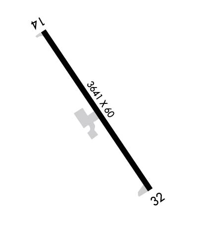
| Lat: N 4142.1 Long: W 09455.2 Elev: 1288 Var: -04 Longest Runway: 3641 | ||
| AWOS: 118.07 CTAF: 122.8 | ||
| ||||||||||||||||||||||||||||||||
| ||||||||||||||||||||||||||||||||
| ||||||||||||||||||||||||||||||||
| Rwy | Rwy | |||||||
| 3641x60 | 3501' | 3641x60 | 3641' | |||||
| Runway ID | Single Wheel | Double Wheel | Double Tandem Wheel | Dual Double Wheel |
| 14/32 | 15,000 | N/A | N/A | N/A |
| These numbers are Advisory and are not limits. The Airport Manager should have more accurate Weight Limits | ||||
 Airport Diagram might not be current. | |
| Facility Name: | AUDUBON COUNTY |
| City Name: | AUDUBON |
| County: | AUDUBON |
| State abbrev: | IA |
| State Name: | IOWA |
| Ownership: | PUBLICLY OWNED |
| Use: | OPEN TO THE PUBLIC |
| Owner's Name: | AUDUBON COUNTY ARPT AUTH; LOU HERBERS CHAIRMAN OFFICE# 712-563-4440. |
| Address: | P.O. BOX 1 |
| AUDUBON, IA 50025 | |
| Owner's Phone: | (712) 563-4440 |
| Manager's Name: | LOU HERBERS |
| Address: | 2110 HIGHWAY 71 |
| AUDUBON, IA 50025 | |
| Phone: | (712) 563-4440 |
| FAA Region: | CENTRAL |
| FAA Field Office: | NONE |

| Date | Sunrise | Sunset |
|---|---|---|
| 09/24/21 Friday | 7:09 | 19:14 |
| 09/25/21 Saturday | 7:10 | 19:12 |
| 09/26/21 Sunday | 7:11 | 19:10 |
| 09/27/21 Monday | 7:12 | 19:09 |
| 09/28/21 Tuesday | 7:13 | 19:07 |
| 09/29/21 Wednesday | 7:14 | 19:05 |
| 09/30/21 Thursday | 7:15 | 19:03 |
| 10/01/21 Friday | 7:16 | 19:02 |
| 10/02/21 Saturday | 7:17 | 19:00 |
| 10/03/21 Sunday | 7:18 | 18:58 |
| 10/04/21 Monday | 7:19 | 18:57 |
| 10/05/21 Tuesday | 7:21 | 18:55 |
| 10/06/21 Wednesday | 7:22 | 18:53 |
| 10/07/21 Thursday | 7:23 | 18:52 |
| Airport Attendance Schedule | UNATTENDED |
| Airport Status | OPERATIONAL (This Status can change at any time - please check NOTAMS) |
| Airport Lighting Schedule | ACTVT MIRL RY 14/32 AND PAPI & REIL RYS 14 & 32 - CTAF. |
| Airport Storage Available | Tie Downs, Hanger |
| Extra Services Available | Crop Dusting |
| Wind Indicator | YES - (lighted) |
| Control Tower | NO |
| CTAF Frequency | 122.800; CTAF OTS INDEFLY. |
| Unicom Frequency | 122.800 |
| Rotating Beacon Color | CLEAR-GREEN (Light Land Airport); ROTG BCN OTS INDEFLY. |
| Segmented Circle | NO |
| Landing Fee | NO |
| Airport Inspected | STATE - performed by STATE AERONAUTICAL PERSONNEL |
| Inspection Date | 12/21/2020 |
| Type of Fuel Available | Grade 100LL, JET A (freeze point -40C) |
| Airframe Repair Service | NONE |
| Power Plant Repair Service | NONE |
| Latitude | N4142.1 |
| Longitude | W09455.2 (ESTIMATED) |
| Arpt Elevation | 1287ft (SURVEYED) |
| Magnetic Variation | 04E |
| 1 miles SE | of AUDUBON |
| Traffic Pattern Altitude | |
| Sectional Chart | OMAHA |
| Operations (Reported) | Yearly | Avg. Daily |
|---|---|---|
| General Aviation Transient | 141 | 0 |
| General Aviation Local | 109 | 0 |
| Air Taxi | 0 | 0 |
| Commerical | 0 | 0 |
| Commuter | 0 | 0 |
| Military | 0 | 0 |
| Aircraft based on Field | |
|---|---|
| General Aviation Singles | 1 |
| General Aviation Multi | 0 |
| Jet Aircraft | 0 |
| General Aviation Helicopters | 0 |
| Military Aircraft | 0 |
| Gliders | 0 |
| Ultralights | 0 |
| FSS on field | NO |
| FSS tie-in | FORT DODGE |
| FSS Phone | 1-800-WX-BRIEF |
| Who issues Notams | ADU |
| Notam D service at airport | YES |
| ARTCC Name | MINNEAPOLIS |
| Airport Certification | |
| Aircraft Rescue & Firefighting Index | None |
| Airport of Entry | No |
| Custom Landing Rights | No |
| Joint Civil/Military | No |
| Military Landing rights | YES |
| NATIONAL PLAN OF INTEGRATED AIRPORT SYSTEMS (NPIAS) |
| GRANT AGREEMENT HAS EXPIRED; HOWEVER, AGREEMENT REMAINS IN EFFECT FOR THIS FACILITY AS LONG AS IT IS PUBLIC USE. |
| RY 14 HAS 64 FT LGTD POLE 1200 FT FM THLD 350 FT L. |
| FOR CD CTC MINNEAPOLIS ARTCC AT 651-463-5588. |
Airport Communications & Frequencies:
| |||||||||
| Runway: 14 | Runway: 32 | ||
| Mag heading: | 143° | Mag heading: | 323° |
| Rwy Slope: | -.29% Down | Rwy Slope: | .29% Up |
| Approach: | Approach: | ||
| Pattern: | Left Traffic | Pattern: | Left Traffic |
| Markings: | NONPRECISION INSTRUMENT | Markings: | NONPRECISION INSTRUMENT |
| Marking Condition: | GOOD | Marking Condition: | GOOD |
| Arresting Dev: | Arresting Dev: | ||
| Lat & Long: | N4142.3 W09455.4 | Lat. & Long.: | N4141.8 W09455.0 |
| Elev: | 1287.7 ft. MSL | Elev: | 1277.2 ft. MSL |
| TCH: | 40 ft. AGL | TCH: | 40 ft. AGL |
| Visual Glide Path: | 3.00 degrees | Visual Glide Path: | 3.25 degrees |
| Displaced Threshold: | 140 feet | Displaced Threshold: | No |
| Touchdown Zone: | YES | Touchdown Zone: | YES |
| Touchdown Elev.: | 1287.5 feet | Touchdown Elev.: | 1286.0 feet |
| Visual Glide Slope: | 2-Light PAPI on LEFT side of Runway | Visual Glide Slope: | 2-Light PAPI on LEFT side of Runway |
| RVR Equipment: | RVR Equipment: | ||
| RVV Equipment: | NO | RVV Equipment: | NO |
| Approach Lights: | Approach Lights: | ||
| REIL: | YES | REIL: | YES |
| Centerline Lights: | NO | Centerline Lights: | NO |
| Touchdown lights: | NO | Touchdown lights: | NO |
| Runway Category: | Runway with a Visual Approach | Runway Category: | Runway with a Non-precision Approach |
| Declared Distances: | Declared Distances: | ||
| Obstructions: | TREE | Obstructions: | BRDG |
| Marked: | NOT Marked/Lighted | Marked: | NOT Marked/Lighted |
| Clearance slope: | 24:1; RWY 14 APCH SLOPE 32:1 TO DSPLCD THLD. | Clearance slope: | 20:1 |
| Obstruction height: | 43 feet AGL | Obstruction height: | 20 feet AGL |
| Dist. from runway: | 1241 feet | Dist. from runway: | 613 feet |
| Centerline offset: | 39 left of centerline | Centerline offset: | 208 feet left of centerline |
| Comments: | Comments: |
Thanks for using FltPlan.com
all rights reserved © 1999-2021 by Flight Plan LLC