
| GASTONIA MUNI GASTONIA NC |
| |
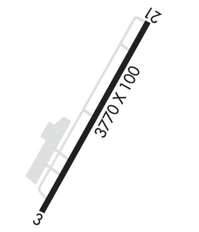
| Lat: N 3512.2 Long: W 08109.0 Elev: 798 Var: +06 Longest Runway: 3769 | ||
| Clr Del: 127.2 AWOS: 135.72 CTAF: 123.0 | ||
| ||||||||||||||||||||||||||||||||||||||||||||
| ||||||||||||||||||||||||||||||||||||||||||||
| ||||||||||||||||||||||||||||||||||||||||||||
| Rwy | Rwy | |||||||
| 3769x100 | 3769' | 3769x100 | 3688' | |||||
| Runway ID | Single Wheel | Double Wheel | Double Tandem Wheel | Dual Double Wheel |
| 03/21 | 24,000 | N/A | N/A | N/A |
| These numbers are Advisory and are not limits. The Airport Manager should have more accurate Weight Limits | ||||
 Airport Diagram might not be current. | |
| Facility Name: | GASTONIA MUNI |
| City Name: | GASTONIA |
| County: | GASTON |
| State abbrev: | NC |
| State Name: | NORTH CAROLINA |
| Ownership: | PUBLICLY OWNED |
| Use: | OPEN TO THE PUBLIC |
| Owner's Name: | CITY OF GASTONIA; STEVE HUSS. |
| Address: | PO BOX 1748 |
| GASTONIA, NC 28053 | |
| Owner's Phone: | (704) 214-9160 |
| Manager's Name: | STEVE HUSS |
| Address: | 1126 GASTON DAY SCHOOL ROAD |
| GASTONIA, NC 28056 | |
| Phone: | 704-869-7844 |
| FAA Region: | SOUTHERN |
| FAA Field Office: | MEM |

| Date | Sunrise | Sunset |
|---|---|---|
| 02/05/25 Wednesday | 7:21 | 17:57 |
| 02/06/25 Thursday | 7:20 | 17:58 |
| 02/07/25 Friday | 7:19 | 17:59 |
| 02/08/25 Saturday | 7:18 | 18:00 |
| 02/09/25 Sunday | 7:17 | 18:01 |
| 02/10/25 Monday | 7:16 | 18:02 |
| 02/11/25 Tuesday | 7:15 | 18:03 |
| 02/12/25 Wednesday | 7:14 | 18:04 |
| 02/13/25 Thursday | 7:13 | 18:05 |
| 02/14/25 Friday | 7:12 | 18:06 |
| 02/15/25 Saturday | 7:11 | 18:07 |
| 02/16/25 Sunday | 7:10 | 18:08 |
| 02/17/25 Monday | 7:09 | 18:09 |
| 02/18/25 Tuesday | 7:08 | 18:10 |
| Airport Attendance Schedule | MON-SUN 0800-1700; UNATNDD CHRISTMAS DAY. |
| Airport Status | OPERATIONAL (This Status can change at any time - please check NOTAMS) |
| Airport Lighting Schedule | ACTVT ODALS RWY 03; PAPI RWY 03 & 21; MIRL RWY 03/21 - CTAF. |
| Airport Storage Available | Tie Downs |
| Extra Services Available | Avionics, Charter |
| Wind Indicator | YES - (lighted) |
| Control Tower | NO |
| CTAF Frequency | 123.000 |
| Unicom Frequency | 123.000 |
| Rotating Beacon Color | WG |
| Segmented Circle | YES |
| Landing Fee | NO |
| Airport Inspected | STATE - performed by STATE AERONAUTICAL PERSONNEL |
| Inspection Date | 07/04/2022 |
| Type of Fuel Available | Grade 100LL, JET A-1 (icing inhibitor, freeze point -50C) |
| Airframe Repair Service | MAJOR |
| Power Plant Repair Service | MAJOR |
| Latitude | N3512.2 |
| Longitude | W08109.0 (ESTIMATED) |
| Arpt Elevation | 797ft (SURVEYED) |
| Magnetic Variation | 06W |
| 4 miles S | of GASTONIA |
| Traffic Pattern Altitude | |
| Sectional Chart | CHARLOTTE |
| Operations (Reported) | Yearly | Avg. Daily |
|---|---|---|
| General Aviation Transient | 0 | 0 |
| General Aviation Local | 0 | 0 |
| Air Taxi | 0 | 0 |
| Commerical | 0 | 0 |
| Commuter | 0 | 0 |
| Military | 0 | 0 |
| Aircraft based on Field | |
|---|---|
| General Aviation Singles | 0 |
| General Aviation Multi | 0 |
| Jet Aircraft | 0 |
| General Aviation Helicopters | 0 |
| Military Aircraft | 0 |
| Gliders | 0 |
| Ultralights | 0 |
| FSS on field | NO |
| FSS tie-in | RALEIGH |
| FSS Phone | 1-800-WX-BRIEF |
| Who issues Notams | AKH |
| Notam D service at airport | YES |
| ARTCC Name | ATLANTA |
| Airport Certification | |
| Aircraft Rescue & Firefighting Index | None |
| Airport of Entry | No |
| Custom Landing Rights | No |
| Joint Civil/Military | No |
| Military Landing rights | YES |
| NATIONAL PLAN OF INTEGRATED AIRPORT SYSTEMS (NPIAS) |
| ASSURANCES PURSUANT TO TITLE VI, CIVIL RIGHTS ACT OF 1964 |
| GRANT AGREEMENT HAS EXPIRED; HOWEVER, AGREEMENT REMAINS IN EFFECT FOR THIS FACILITY AS LONG AS IT IS PUBLIC USE. |
| RWY 03 - 15 FT ROAD 292 FT FM THR L & R OF CNTRLN. |
| RWY 21 - 50 FT DROP-OFF 300 FT FM DSPLCD THR L&R OF CNTRLN AND UNMARKED PLINES 370 FT FM DSPLCD THR L&R OF CNTRLN. |
| NOISE ABATEMENT: FROM 2200-0600 PILOTS ARE REQUESTED TO USE RWY 21 AS CALM WIND RWY & DO RUNUPS ON RAMP; NOT RWY END. TO AVOID LOW ALT TURNS TO THE WEST REQ CLNC THRU CLASS B ASP FROM CHARLOTTE APCH. |
| DEER ON & INVOF ARPT. |
| FOR CD CTC CHARLOTTE APCH AT 704-359-0241. |
| RWY 03/21 NO LINE OF SIGHT BTN RWY ENDS. |
Airport Communications & Frequencies:
| ||||||||||||||||
| Runway: 03 | Runway: 21 | ||
| Mag heading: | 34° | Mag heading: | 214° |
| Rwy Slope: | -.42% Down | Rwy Slope: | .42% Up |
| Approach: | Approach: | ||
| Pattern: | Left Traffic | Pattern: | Left Traffic |
| Markings: | NONPRECISION INSTRUMENT | Markings: | NONPRECISION INSTRUMENT |
| Marking Condition: | GOOD | Marking Condition: | GOOD |
| Arresting Dev: | Arresting Dev: | ||
| Lat & Long: | N3511.9 W08109.2 | Lat. & Long.: | N3512.4 W08108.8 |
| Elev: | 795.5 ft. MSL | Elev: | 779.8 ft. MSL |
| TCH: | 26 ft. AGL | TCH: | 38 ft. AGL |
| Visual Glide Path: | 3.00 degrees | Visual Glide Path: | 3.00 degrees |
| Displaced Threshold: | No | Displaced Threshold: | 81 feet |
| Touchdown Zone: | YES | Touchdown Zone: | YES |
| Touchdown Elev.: | 797.9 feet | Touchdown Elev.: | 797.9 feet |
| Visual Glide Slope: | 2-Light PAPI on RIGHT side of Runway | Visual Glide Slope: | 2-Light PAPI on LEFT side of Runway |
| RVR Equipment: | RVR Equipment: | ||
| RVV Equipment: | NO | RVV Equipment: | NO |
| Approach Lights: | ODALS - omnidirectional approach lighting system | Approach Lights: | |
| REIL: | NO | REIL: | NO |
| Centerline Lights: | NO | Centerline Lights: | NO |
| Touchdown lights: | NO | Touchdown lights: | NO |
| Runway Category: | Runway with a Non-precision Approach | Runway Category: | Runway with a Non-precision Approach |
| Declared Distances: | Declared Distances: | ||
| Obstructions: | ROAD | Obstructions: | TREES |
| Marked: | NOT Marked/Lighted | Marked: | NOT Marked/Lighted |
| Clearance slope: | 7:1 | Clearance slope: | 1:1; APCH SLOPE 4:1 TO DSPLCD THR DUE TO 30 FT TREES LOCATED 333 FT FRM DSPLCD THR OFFSET 93 FT RIGHT OF CNTRLN. |
| Obstruction height: | 10 feet AGL | Obstruction height: | 31 feet AGL |
| Dist. from runway: | 279 feet | Dist. from runway: | 255 feet |
| Centerline offset: | Centerline offset: | 90 feet right of centerline | |
| Comments: | Comments: |
Thanks for using FltPlan.com
all rights reserved © 1999-2025 by Flight Plan LLC