
| HARRIET ALEXANDER FIELD SALIDA CO |
| |
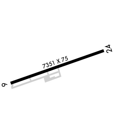
| Lat: N 3832.3 Long: W 10602.9 Elev: 7523 Var: -09 Longest Runway: 7351 | ||
| AWOS: 133.85 CTAF: 122.7 | ||
| |||||||||||||||||||||||||||||||||||||||||||||||||||||||||||||
| |||||||||||||||||||||||||||||||||||||||||||||||||||||||||||||
| |||||||||||||||||||||||||||||||||||||||||||||||||||||||||||||
| |||||||||||||||||||||||||||||||||||||||||||||||||||||||||||||
| Rwy | Rwy | |||||||
| 7351x75 | 7351' | 7351x75 | 7351' | |||||
| Runway ID | Single Wheel | Double Wheel | Double Tandem Wheel | Dual Double Wheel |
| 06/24 | 30,000 | 60,000 | N/A | N/A |
| H1 | N/A | N/A | N/A | N/A |
| These numbers are Advisory and are not limits. The Airport Manager should have more accurate Weight Limits | ||||
 Airport Diagram might not be current. | |
| Facility Name: | SALIDA/HARRIETT ALEXANDER FLD |
| City Name: | SALIDA |
| County: | CHAFFEE |
| State abbrev: | CO |
| State Name: | COLORADO |
| Ownership: | PUBLICLY OWNED |
| Use: | OPEN TO THE PUBLIC |
| Owner's Name: | CITY OF SALIDA/CHAFFEE COUNTY; COUNTY CONTACT: ROBERT CHRISTIANSEN |
| Address: | COUNTY COURTHOUSE |
| SALIDA, CO 81201 | |
| Owner's Phone: | 719-539-2218 |
| Manager's Name: | ZECHARIAH PAPP |
| Address: | 9255 COUNTY ROAD 140 |
| SALIDA, CO 81201 | |
| Phone: | (719) 239-1648 |
| FAA Region: | NORTHWEST MOUNTAIN |
| FAA Field Office: | DEN |
| Date | Sunrise | Sunset |
|---|---|---|
| 03/29/25 Saturday | 6:54 | 19:25 |
| 03/30/25 Sunday | 6:52 | 19:26 |
| 03/31/25 Monday | 6:51 | 19:27 |
| 04/01/25 Tuesday | 6:49 | 19:27 |
| 04/02/25 Wednesday | 6:48 | 19:28 |
| 04/03/25 Thursday | 6:46 | 19:29 |
| 04/04/25 Friday | 6:45 | 19:30 |
| 04/05/25 Saturday | 6:43 | 19:31 |
| 04/06/25 Sunday | 6:42 | 19:32 |
| 04/07/25 Monday | 6:40 | 19:33 |
| 04/08/25 Tuesday | 6:39 | 19:34 |
| 04/09/25 Wednesday | 6:37 | 19:35 |
| 04/10/25 Thursday | 6:36 | 19:36 |
| 04/11/25 Friday | 6:34 | 19:37 |
| Airport Attendance Schedule | WED-SUN 0800-1700 |
| Airport Status | OPERATIONAL (This Status can change at any time - please check NOTAMS) |
| Airport Lighting Schedule | ACTVT PAPI RWY 06 & 24; MIRL RWY 06/24 - CTAF. |
| Airport Storage Available | Tie Downs |
| Extra Services Available | Air Ambulance |
| Wind Indicator | YES - (lighted) |
| Control Tower | NO |
| CTAF Frequency | 122.700 |
| Unicom Frequency | 122.700 |
| Rotating Beacon Color | WG |
| Segmented Circle | YES |
| Landing Fee | NO |
| Airport Inspected | STATE - performed by STATE AERONAUTICAL PERSONNEL |
| Inspection Date | 06/17/2024 |
| Type of Fuel Available | Grade 100LL, JET A; -10FUEL AVBL WITH CREDIT CARD. |
| Airframe Repair Service | None |
| Power Plant Repair Service | None |
| Latitude | N3832.3 |
| Longitude | W10602.9 (ESTIMATED) |
| Arpt Elevation | 7522ft (SURVEYED) |
| Magnetic Variation | 09E |
| 2 miles W | of SALIDA |
| Traffic Pattern Altitude | |
| Sectional Chart | DENVER |
| Operations (Reported) | Yearly | Avg. Daily |
|---|---|---|
| General Aviation Transient | 0 | 0 |
| General Aviation Local | 0 | 0 |
| Air Taxi | 0 | 0 |
| Commerical | 0 | 0 |
| Commuter | 0 | 0 |
| Military | 0 | 0 |
| Aircraft based on Field | |
|---|---|
| General Aviation Singles | 0 |
| General Aviation Multi | 0 |
| Jet Aircraft | 0 |
| General Aviation Helicopters | 0 |
| Military Aircraft | 0 |
| Gliders | 0 |
| Ultralights | 0 |
| FSS on field | NO |
| FSS tie-in | DENVER |
| FSS Phone | 1-800-WX-BRIEF |
| Who issues Notams | DEN |
| Notam D service at airport | YES |
| ARTCC Name | DENVER |
| Airport Certification | |
| Aircraft Rescue & Firefighting Index | None |
| Airport of Entry | No |
| Custom Landing Rights | No |
| Joint Civil/Military | No |
| Military Landing rights | YES |
| NATIONAL PLAN OF INTEGRATED AIRPORT SYSTEMS (NPIAS) |
| GRANT AGREEMENTS UNDER FAAP/ADAP/AIP |
| ASSURANCES PURSUANT TO TITLE VI, CIVIL RIGHTS ACT OF 1964 |
| BE ALERT; INTENSIVE USAF STUDENT TRAINING IN VICINITY OF COLORADO SPRINGS & PUEBLO COLORADO. |
| FOR CD CTC DENVER ARTCC AT 303-651-4257. |
| RY 24 HAS 365 FT UNLIGHTED SMOKESTACK 5082 FT FM THLD 2500 FT R OF CNTRLN. |
| DURING HIGH WIND CONDITIONS DOWNDRAFTS APPROACHING RY 24. |
| RY 24 RECOMMENDED FOR LANDING; RY 06 FOR DEPARTURE WEATHER & TRAFFIC PERMITTING. |
| RY 06 +60 FT POWERLINE MARKED WITH ORANGE BALLS 630 FT FM THLD, 435 FT LEFT OF RY EXTDD CNTRLN. |
Airport Communications & Frequencies:
| |||||||||
| Runway: 06 | Runway: 24 | ||
| Mag heading: | 62° | Mag heading: | 242° |
| Rwy Slope: | -1.88% Down | Rwy Slope: | 1.88% Up |
| Approach: | Approach: | ||
| Pattern: | Left Traffic | Pattern: | Left Traffic |
| Markings: | BASIC | Markings: | BASIC |
| Marking Condition: | GOOD | Marking Condition: | GOOD |
| Arresting Dev: | Arresting Dev: | ||
| Lat & Long: | N3832.1 W10603.6 | Lat. & Long.: | N3832.5 W10602.2 |
| Elev: | 7523.0 ft. MSL | Elev: | 7384.7 ft. MSL |
| TCH: | 35 ft. AGL | TCH: | 42 ft. AGL |
| Visual Glide Path: | 3.50 degrees | Visual Glide Path: | 3.00 degrees |
| Displaced Threshold: | No | Displaced Threshold: | No |
| Touchdown Zone: | YES | Touchdown Zone: | YES |
| Touchdown Elev.: | 7523.0 feet | Touchdown Elev.: | 7441.5 feet |
| Visual Glide Slope: | 2-Light PAPI on LEFT side of Runway | Visual Glide Slope: | 2-Light PAPI on LEFT side of Runway; PAPI DOES NOT PROVIDE OBSTACLE CLEARANCE BYD 2 NM FROM THRESHOLD, UNUSABLE BYD 2 NM. |
| RVR Equipment: | RVR Equipment: | ||
| RVV Equipment: | NO | RVV Equipment: | NO |
| Approach Lights: | Approach Lights: | ||
| REIL: | NO | REIL: | NO |
| Centerline Lights: | NO | Centerline Lights: | NO |
| Touchdown lights: | NO | Touchdown lights: | NO |
| Runway Category: | Runway with a Visual Approach | Runway Category: | Runway with a Visual Approach |
| Declared Distances: | Declared Distances: | ||
| Obstructions: | ROAD | Obstructions: | |
| Marked: | NOT Marked/Lighted | Marked: | |
| Clearance slope: | 20:1 | Clearance slope: | 50:1 |
| Obstruction height: | 32 feet AGL | Obstruction height: | |
| Dist. from runway: | 850 feet | Dist. from runway: | |
| Centerline offset: | 24 right of centerline | Centerline offset: | |
| Comments: | Comments: |
Thanks for using FltPlan.com
all rights reserved © 1999-2025 by Flight Plan LLC

