
| ALTOONA-BLAIR COUNTY ALTOONA PA |
| |
| Lat: N 4017.8 Long: W 07819.2 Elev: 1503 Var: +10 Longest Runway: 5465 | ||
| AWOS: 127.12 CTAF: 123.6 | ||
| ||||||
| ||||||
|
| Rwy | Rwy | |||||||
| 5465x100 | 5465' | 5465x100 | 5465' | 111.10 - 206° | ||||
| 3668x75 | 3668' | 3668x75 | 3668' | |||||
| Runway ID | Single Wheel | Double Wheel | Double Tandem Wheel | Dual Double Wheel |
| 03/21 | 16,000 | 44,000 | N/A | N/A |
| 12/30 | 11,500 | 33,000 | N/A | N/A |
| These numbers are Advisory and are not limits. The Airport Manager should have more accurate Weight Limits | ||||
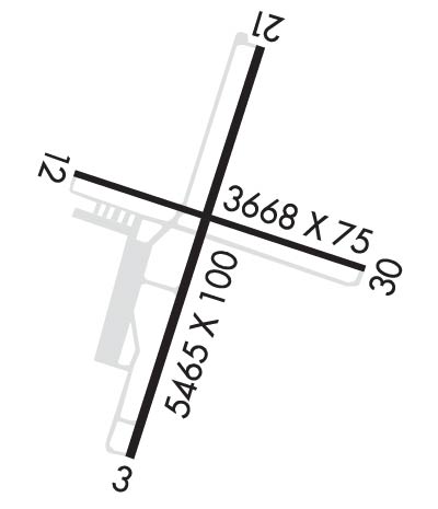 Airport Diagram might not be current. | |
| Facility Name: | ALTOONA-BLAIR COUNTY |
| City Name: | ALTOONA |
| County: | BLAIR |
| State abbrev: | PA |
| State Name: | PENNSYLVANIA |
| Ownership: | PUBLICLY OWNED |
| Use: | OPEN TO THE PUBLIC |
| Owner's Name: | BLAIR COUNTY AIRPORT AUTH |
| Address: | 310 AIRPORT DRIVE, SUITE 6 |
| MARTINSBURG, PA 16662 | |
| Owner's Phone: | (814) 793-2027 |
| Manager's Name: | TRACY PLESSINGER |
| Address: | 310 AIRPORT DRIVE, SUITE 6 |
| MARTINSBURG, PA 16662 | |
| Phone: | 814-793-2027 |
| FAA Region: | EASTERN |
| FAA Field Office: | HAR |
| Date | Sunrise | Sunset |
|---|---|---|
| 09/24/21 Friday | 7:02 | 19:07 |
| 09/25/21 Saturday | 7:03 | 19:06 |
| 09/26/21 Sunday | 7:04 | 19:04 |
| 09/27/21 Monday | 7:05 | 19:02 |
| 09/28/21 Tuesday | 7:06 | 19:01 |
| 09/29/21 Wednesday | 7:07 | 18:59 |
| 09/30/21 Thursday | 7:08 | 18:58 |
| 10/01/21 Friday | 7:09 | 18:56 |
| 10/02/21 Saturday | 7:10 | 18:54 |
| 10/03/21 Sunday | 7:11 | 18:53 |
| 10/04/21 Monday | 7:12 | 18:51 |
| 10/05/21 Tuesday | 7:13 | 18:49 |
| 10/06/21 Wednesday | 7:14 | 18:48 |
| 10/07/21 Thursday | 7:15 | 18:46 |
| Airport Attendance Schedule | MON-FRI 0430-2230, SAT 0730-1930, SUN 0830-2030 |
| Airport Status | OPERATIONAL (This Status can change at any time - please check NOTAMS) |
| Airport Lighting Schedule | HIRL RY 03/21 & MIRL RY 12/30 PRESET LOW INTST, INCR INTST & ACTVT PAPI RYS 12, 30, 03 & 21, MALSR RY 21 & REIL RYS 03, 12, & 30 - CTAF. |
| Airport Storage Available | Tie Downs, Hanger |
| Extra Services Available | Avionics, Cargo Handling, Charter, Flight Instruction, Aircraft Rental, Aircraft Sales |
| Wind Indicator | YES - (lighted) |
| Control Tower | NO |
| CTAF Frequency | 123.600 |
| Unicom Frequency | 123.000 |
| Rotating Beacon Color | CLEAR-GREEN (Light Land Airport) |
| Segmented Circle | YES |
| Landing Fee | NO |
| Airport Inspected | STATE - performed by FAA AIRPORTS FIELD PERSONNEL |
| Inspection Date | 03/05/2019 |
| Type of Fuel Available | Grade 100LL, JET A (freeze point -40C) |
| Airframe Repair Service | MAJOR |
| Power Plant Repair Service | MAJOR |
| Latitude | N4017.8 |
| Longitude | W07819.2 (ESTIMATED) |
| Arpt Elevation | 1503ft (SURVEYED) |
| Magnetic Variation | 10W |
| 12 miles S | of ALTOONA |
| Traffic Pattern Altitude | |
| Sectional Chart | DETROIT |
| Operations (Reported) | Yearly | Avg. Daily |
|---|---|---|
| General Aviation Transient | 14000 | 38 |
| General Aviation Local | 4500 | 12 |
| Air Taxi | 5150 | 14 |
| Commerical | 0 | 0 |
| Commuter | 0 | 0 |
| Military | 100 | 0 |
| Aircraft based on Field | |
|---|---|
| General Aviation Singles | 23 |
| General Aviation Multi | 4 |
| Jet Aircraft | 1 |
| General Aviation Helicopters | 0 |
| Military Aircraft | 0 |
| Gliders | 0 |
| Ultralights | 0 |
| FSS on field | NO |
| FSS tie-in | ALTOONA |
| FSS Phone | 1-800-WX-BRIEF |
| Who issues Notams | AOO |
| Notam D service at airport | YES |
| ARTCC Name | CLEVELAND |
| Airport Certification | AIRPORT RECEIVING SCHEDULED AIR CARRIER SERVICE FROM CARRIERS CERTIFICATED BY THE CIVIL AERONAUTICS BOARD; PPR 24 FOR UNSKED ACR & NON-ACR OPNS WITH MORE THAN 30 PSGR SEATS; CALL AMGR 814-793-2027. |
| Aircraft Rescue & Firefighting Index | AIRPORT HAS A CERTIFICATE UNDER CFR PART 139 |
| Airport of Entry | No |
| Custom Landing Rights | No |
| Joint Civil/Military | No |
| Military Landing rights | YES |
| NATIONAL PLAN OF INTEGRATED AIRPORT SYSTEMS (NPIAS) |
| GRANT AGREEMENTS UNDER FAAP/ADAP/AIP |
| ASSURANCES PURSUANT TO TITLE VI, CIVIL RIGHTS ACT OF 1964 |
| COMPLIANCE WITH ACCESSIBILITY TO THE HANDICAPPED |
| PREFERRED RWY IS RWY 21; FOR NOISE ABATEMENT WHEN DEP RWY 03 MAINT RWY HDG TIL 2 NM N OF ARPT. |
| SPECIALIZED ACFT (ULTRALGT, HOMEBUILT, ETC) CTC AMGR 814-793-2027 OR UNICOM PRIOR TO LDG. |
| RWY/TWY CONDITIONS UNMONITORED OUTSIDE OF NML ATTENDANCE HRS. |
| FOR CD CTC JOHNSTOWN APCH AT 814-532-5960, WHEN APCH CLSD CTC CLEVELAND ARTCC AT 440-774-0234. |
| RWY 03/2 1 RY 03/21, THRESHOLD LGTS & EDGE LGTS OTS EXCEPT WITH PCL, AVBL FM 0100-1300Z DAILY. |
| RWY 12/3 0 RY 12/30, THRESHOLD LGTS & EDGE LGTS OTS EXCEPT WITH PCL, AVBL FM 0100-1300Z DAILY. |
Airport Communications & Frequencies:
| |||||||||||||||||
| Runway: 03 | Runway: 21 | ||
| Mag heading: | 26° | Mag heading: | 206° |
| Rwy Slope: | -.62% Down | Rwy Slope: | .62% Up |
| Approach: | Approach: | ILS | |
| Pattern: | Left Traffic | Pattern: | Left Traffic |
| Markings: | NONPRECISION INSTRUMENT | Markings: | PRECISION INSTRUMENT |
| Marking Condition: | GOOD | Marking Condition: | GOOD |
| Arresting Dev: | Arresting Dev: | ||
| Lat & Long: | N4017.3 W07819.4 | Lat. & Long.: | N4018.2 W07819.1 |
| Elev: | 1503.4 ft. MSL | Elev: | 1469.3 ft. MSL |
| TCH: | 43 ft. AGL | TCH: | 52 ft. AGL |
| Visual Glide Path: | 3.00 degrees | Visual Glide Path: | 3.00 degrees |
| Displaced Threshold: | No | Displaced Threshold: | No |
| Touchdown Zone: | YES | Touchdown Zone: | YES |
| Touchdown Elev.: | 1503.4 feet | Touchdown Elev.: | 1486.2 feet |
| Visual Glide Slope: | 4-Light PAPI on LEFT side of Runway | Visual Glide Slope: | 4-Light PAPI on LEFT side of Runway |
| RVR Equipment: | RVR Equipment: | ||
| RVV Equipment: | NO | RVV Equipment: | NO |
| Approach Lights: | Approach Lights: | MALSR - 1,400 foot medium intensity approach lighting system with runway alignment indicator lights | |
| REIL: | YES | REIL: | NO |
| Centerline Lights: | NO | Centerline Lights: | NO |
| Touchdown lights: | NO | Touchdown lights: | NO |
| Runway Category: | Runway with a Non-precision Approach having visibility minimums greater than 3/4 mile | Runway Category: | Precision Instrument Runway |
| Declared Distances: | TORA:5465' TODA:5465' ASDA:5465' LDA:5465' | Declared Distances: | TORA:5465' TODA:5465' ASDA:5465' LDA:5465' |
| Obstructions: | TREES | Obstructions: | TREES |
| Marked: | NOT Marked/Lighted | Marked: | NOT Marked/Lighted |
| Clearance slope: | 15:1 | Clearance slope: | 26:1 |
| Obstruction height: | 45 feet AGL | Obstruction height: | 67 feet AGL |
| Dist. from runway: | 904 feet | Dist. from runway: | 1949 feet |
| Centerline offset: | 522 left of centerline | Centerline offset: | 687 feet right of centerline |
| Comments: | Comments: |
| Runway: 12 | Runway: 30 | ||
| Mag heading: | 118° | Mag heading: | 298° |
| Rwy Slope: | .24% Up | Rwy Slope: | -.24% Down |
| Approach: | Approach: | ||
| Pattern: | Left Traffic | Pattern: | Left Traffic |
| Markings: | BASIC | Markings: | BASIC |
| Marking Condition: | GOOD | Marking Condition: | GOOD |
| Arresting Dev: | Arresting Dev: | ||
| Lat & Long: | N4017.9 W07819.5 | Lat. & Long.: | N4017.7 W07818.8 |
| Elev: | 1472.8 ft. MSL | Elev: | 1481.5 ft. MSL |
| TCH: | 54 ft. AGL | TCH: | 54 ft. AGL |
| Visual Glide Path: | 3.00 degrees | Visual Glide Path: | 4.00 degrees |
| Displaced Threshold: | No | Displaced Threshold: | No |
| Touchdown Zone: | YES | Touchdown Zone: | YES |
| Touchdown Elev.: | 1479.8 feet | Touchdown Elev.: | 1481.6 feet |
| Visual Glide Slope: | 4-Light PAPI on LEFT side of Runway | Visual Glide Slope: | 4-Light PAPI on RIGHT side of Runway |
| RVR Equipment: | RVR Equipment: | ||
| RVV Equipment: | NO | RVV Equipment: | NO |
| Approach Lights: | Approach Lights: | ||
| REIL: | YES | REIL: | YES |
| Centerline Lights: | NO | Centerline Lights: | NO |
| Touchdown lights: | NO | Touchdown lights: | NO |
| Runway Category: | Runway with a Visual Approach | Runway Category: | Runway with a Visual Approach |
| Declared Distances: | TORA:3668' TODA:3668' ASDA:3668' LDA:3668' | Declared Distances: | TORA:3668' TODA:3668' ASDA:3668' LDA:3668' |
| Obstructions: | TREES | Obstructions: | TREE |
| Marked: | NOT Marked/Lighted | Marked: | NOT Marked/Lighted |
| Clearance slope: | 18:1 | Clearance slope: | 15:1 |
| Obstruction height: | 39 feet AGL | Obstruction height: | 36 feet AGL |
| Dist. from runway: | 919 feet | Dist. from runway: | 711 feet |
| Centerline offset: | 287 left of centerline | Centerline offset: | 93 feet right of centerline |
| Comments: | Comments: | HAS + 4 FT GND 20 FT FM RY END 215 FT RIGHT. |
Thanks for using FltPlan.com
all rights reserved © 1999-2021 by Flight Plan LLC
