
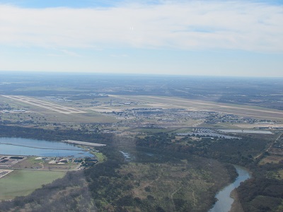
| AUSTIN-BERGSTROM INTL AUSTIN TX |
| |
| Lat: N 3011.7 Long: W 09740.2 Elev: 542 Var: -04 Longest Runway: 12250 | ||
| Clr Del: 125.5 Dept. ATIS: 124.4 Arr. ATIS: 124.4 Ground: 121.7/121.9 Tower: 121.0 | ||

| |||||||||||||||||||||||||||||||||||||||||||||||||||||||||||||||||||||
| |||||||||||||||||||||||||||||||||||||||||||||||||||||||||||||||||||||
| |||||||||||||||||||||||||||||||||||||||||||||||||||||||||||||||||||||
| |||||||||||||||||||||||||||||||||||||||||||||||||||||||||||||||||||||
| |||||||||||||||||||||||||||||||||||||||||||||||||||||||||||||||||||||
| |||||||||||||||||||||||||||||||||||||||||||||||||||||||||||||||||||||
| FBOs at nearby airports who want your business: | |||||||||||
| |||||||||||
| Rwy | Rwy | |||||||
| 9000x150 | 9000' | 110.50 - 174° | 9000x150 | 9000' | 110.50 - 354° | |||
| 12250x150 | 12250' | 110.95 - 174° | 12250x150 | 12250' | 110.95 - 354° | |||
| Runway ID | Single Wheel | Double Wheel | Double Tandem Wheel | Dual Double Wheel |
| 18L/36R | 75,000 | 210,000 | 618,000 | 913,000 |
| 18R/36L | 75,000 | 210,000 | 618,000 | 913,000 |
| H1 | N/A | N/A | N/A | N/A |
| H2 | N/A | N/A | N/A | N/A |
| H3 | N/A | N/A | N/A | N/A |
| These numbers are Advisory and are not limits. The Airport Manager should have more accurate Weight Limits | ||||
 Airport Diagram might not be current. | |
| Facility Name: | AUSTIN-BERGSTROM INTL |
| City Name: | AUSTIN |
| County: | TRAVIS |
| State abbrev: | TX |
| State Name: | TEXAS |
| Ownership: | PUBLICLY OWNED |
| Use: | OPEN TO THE PUBLIC |
| Owner's Name: | CITY OF AUSTIN |
| Address: | PO BOX 1088 |
| AUSTIN, TX 78767 | |
| Owner's Phone: | 512-974-2000 |
| Manager's Name: | JACQUELINE YAFT |
| Address: | 3600 PRESIDENTIAL BLVD, SUITE 411 |
| AUSTIN, TX 78719 | |
| Phone: | 512-530-2242 |
| FAA Region: | SOUTHWEST |
| FAA Field Office: | TEX |
| Date | Sunrise | Sunset |
|---|---|---|
| 09/24/21 Friday | 7:20 | 19:25 |
| 09/25/21 Saturday | 7:21 | 19:24 |
| 09/26/21 Sunday | 7:21 | 19:22 |
| 09/27/21 Monday | 7:22 | 19:21 |
| 09/28/21 Tuesday | 7:22 | 19:20 |
| 09/29/21 Wednesday | 7:23 | 19:19 |
| 09/30/21 Thursday | 7:23 | 19:18 |
| 10/01/21 Friday | 7:24 | 19:16 |
| 10/02/21 Saturday | 7:25 | 19:15 |
| 10/03/21 Sunday | 7:25 | 19:14 |
| 10/04/21 Monday | 7:26 | 19:13 |
| 10/05/21 Tuesday | 7:26 | 19:11 |
| 10/06/21 Wednesday | 7:27 | 19:10 |
| 10/07/21 Thursday | 7:28 | 19:09 |
| Airport Attendance Schedule | CONTINUOUS |
| Airport Status | OPERATIONAL (This Status can change at any time - please check NOTAMS) |
| Airport Lighting Schedule | SS-SR |
| Airport Storage Available | Tie Downs, Hanger |
| Extra Services Available | Air Freight, Avionics, Cargo Handling, Charter, Flight Instruction, Aircraft Rental, Aircraft Sales |
| Wind Indicator | YES - (lighted) |
| Control Tower | YES |
| CTAF Frequency | |
| Unicom Frequency | 122.950 |
| Rotating Beacon Color | CLEAR-GREEN (Light Land Airport) |
| Segmented Circle | NO |
| Landing Fee | NO |
| Airport Inspected | FEDERAL - performed by FAA AIRPORTS FIELD PERSONNEL |
| Inspection Date | 05/12/2021 |
| Type of Fuel Available | Grade 100LL, JET A (freeze point -40C) |
| Airframe Repair Service | MINOR |
| Power Plant Repair Service | MINOR |
| Latitude | N3011.7 |
| Longitude | W09740.2 (ESTIMATED) |
| Arpt Elevation | 541ft (SURVEYED) |
| Magnetic Variation | 04E |
| 5 miles SE | of AUSTIN |
| Traffic Pattern Altitude | |
| Sectional Chart | SAN ANTONIO |
| Operations (Reported) | Yearly | Avg. Daily |
|---|---|---|
| General Aviation Transient | 34084 | 93 |
| General Aviation Local | 200 | 1 |
| Air Taxi | 14683 | 40 |
| Commerical | 64280 | 176 |
| Commuter | 0 | 0 |
| Military | 5093 | 14 |
| Aircraft based on Field | |
|---|---|
| General Aviation Singles | 80 |
| General Aviation Multi | 13 |
| Jet Aircraft | 54 |
| General Aviation Helicopters | 5 |
| Military Aircraft | 22 |
| Gliders | 0 |
| Ultralights | 0 |
| FSS on field | NO |
| FSS tie-in | SAN ANGELO |
| FSS Phone | 1-800-WX-BRIEF |
| Who issues Notams | AUS |
| Notam D service at airport | YES |
| ARTCC Name | HOUSTON |
| Airport Certification | AIRPORT RECEIVING SCHEDULED AIR CARRIER SERVICE FROM CARRIERS CERTIFICATED BY THE CIVIL AERONAUTICS BOARD |
| Aircraft Rescue & Firefighting Index | AIRPORT HAS A CERTIFICATE UNDER CFR PART 139 |
| Airport of Entry | No |
| Custom Landing Rights | YES |
| Joint Civil/Military | No |
| Military Landing rights | YES |
| NATIONAL PLAN OF INTEGRATED AIRPORT SYSTEMS (NPIAS) |
| GRANT AGREEMENTS UNDER FAAP/ADAP/AIP |
| SURPLUS PROPERTY AGREEMENT UNDER PUBLIC LAW 289 |
| ASSURANCES PURSUANT TO TITLE VI, CIVIL RIGHTS ACT OF 1964 |
| BIRD ACTIVITY ON & INVOF ARPT. |
| DECLARED LOW VISIBILITY CONDS REQUIRE ATCT COMMUNICATION PRIOR TO PUSH BACK. |
| TXLN C2 BTWN G1 AND G3, AND TXLN R1 AND R5 CLSD 2000-0800L |
| PPR GA ACFT ON THE PSGR TERMINAL APRON, CALL OPS 512-530-7550. |
| ARNG: OPR 1300-2300++ TUE-FRI, DSN 954-5001 EXT 7024614, C512-356-7900 EXT 7024614. |
| TWY A CLSD TO ACFT WITH WINGSPAN MORE THAN 171 FT. |
| PPR FOR NON STATE OF TEXAS AIRCRAFT ENTERING THE STATE RAMP ABEAM TWY E. CALL STATE OPS 512-936-8900 OR FREQ. 131.375. |
| DURG THE HRS 0000-0600 ARRG ACFT WILL BE ASGND RWY 36L OR RWY 36R & DEPARTING ACFT WILL BE ASGND RWY 18L OR RWY 18R TO AVOID NOISE SENSITIVE AREAS. |
| NOISE ABATEMENT: ALL DEP FOLLOW ATC INSTRUCTIONS; CLIMB ASAP TO 4000 FT OR ABOVE. |
| PPR ENGINE MAINTENANCE RUN UPS CALL OPS 512-530-7550. |
Airport Communications & Frequencies:
| ||||||||||||||||||||||||||||||||||||||||||||||||||||||||||||
| Runway: 18L | Runway: 36R | ||
| Mag heading: | 175° | Mag heading: | 355° |
| Rwy Slope: | -.20% Down | Rwy Slope: | .20% Up |
| Approach: | ILS/DME | Approach: | ILS/DME |
| Pattern: | Left Traffic | Pattern: | Right Traffic |
| Markings: | PRECISION INSTRUMENT | Markings: | PRECISION INSTRUMENT |
| Marking Condition: | GOOD | Marking Condition: | GOOD |
| Arresting Dev: | Arresting Dev: | ||
| Lat & Long: | N3012.2 W09739.5 | Lat. & Long.: | N3010.7 W09739.4 |
| Elev: | 491.6 ft. MSL | Elev: | 473.6 ft. MSL |
| TCH: | 74 ft. AGL | TCH: | 59 ft. AGL |
| Visual Glide Path: | 3.00 degrees | Visual Glide Path: | 3.00 degrees |
| Displaced Threshold: | No | Displaced Threshold: | No |
| Touchdown Zone: | YES | Touchdown Zone: | YES |
| Touchdown Elev.: | 491.6 feet | Touchdown Elev.: | 479.6 feet |
| Visual Glide Slope: | 4-Light PAPI on LEFT side of Runway | Visual Glide Slope: | 4-Light PAPI on LEFT side of Runway |
| RVR Equipment: | TOUCHDOWN-MIDFIELD-ROLLOUT | RVR Equipment: | TOUCHDOWN-MIDFIELD-ROLLOUT |
| RVV Equipment: | NO | RVV Equipment: | NO |
| Approach Lights: | ALSF2 - standard 2,400 foot high intensity approach lighting system with sequenced flashers, Category II or III | Approach Lights: | MALSR - 1,400 foot medium intensity approach lighting system with runway alignment indicator lights |
| REIL: | NO | REIL: | NO |
| Centerline Lights: | YES | Centerline Lights: | YES |
| Touchdown lights: | YES | Touchdown lights: | YES |
| Runway Category: | Precision Instrument Runway | Runway Category: | Precision Instrument Runway |
| Declared Distances: | TORA:9000' TODA:9000' ASDA:9000' LDA:9000' | Declared Distances: | TORA:9000' TODA:9000' ASDA:9000' LDA:9000' |
| Obstructions: | TOWER | Obstructions: | |
| Marked: | LIGHTED | Marked: | |
| Clearance slope: | 40:1 | Clearance slope: | 50:1 |
| Obstruction height: | 90 feet AGL | Obstruction height: | |
| Dist. from runway: | 3807 feet | Dist. from runway: | |
| Centerline offset: | 236 right of centerline | Centerline offset: | |
| Comments: | Comments: |
| Runway: 18R | Runway: 36L | ||
| Mag heading: | 175° | Mag heading: | 355° |
| Rwy Slope: | -.44% Down | Rwy Slope: | .44% Up |
| Approach: | ILS/DME | Approach: | ILS/DME |
| Pattern: | Right Traffic | Pattern: | Left Traffic |
| Markings: | PRECISION INSTRUMENT | Markings: | PRECISION INSTRUMENT |
| Marking Condition: | GOOD | Marking Condition: | GOOD |
| Arresting Dev: | BAK-12B | Arresting Dev: | |
| Lat & Long: | N3012.8 W09740.8 | Lat. & Long.: | N3010.8 W09740.7 |
| Elev: | 541.4 ft. MSL | Elev: | 487.3 ft. MSL |
| TCH: | 60 ft. AGL | TCH: | 60 ft. AGL |
| Visual Glide Path: | 3.00 degrees | Visual Glide Path: | 3.00 degrees |
| Displaced Threshold: | No | Displaced Threshold: | No |
| Touchdown Zone: | YES | Touchdown Zone: | YES |
| Touchdown Elev.: | 541.5 feet | Touchdown Elev.: | 495.7 feet |
| Visual Glide Slope: | 4-Light PAPI on LEFT side of Runway | Visual Glide Slope: | 4-Light PAPI on LEFT side of Runway |
| RVR Equipment: | TOUCHDOWN-ROLLOUT | RVR Equipment: | TOUCHDOWN-ROLLOUT |
| RVV Equipment: | NO | RVV Equipment: | NO |
| Approach Lights: | MALS - 1,400 foot medium intensity approach lighting system | Approach Lights: | MALS - 1,400 foot medium intensity approach lighting system |
| REIL: | NO | REIL: | NO |
| Centerline Lights: | NO | Centerline Lights: | NO |
| Touchdown lights: | NO | Touchdown lights: | NO |
| Runway Category: | Precision Instrument Runway | Runway Category: | Precision Instrument Runway |
| Declared Distances: | TORA:12250' TODA:12250' ASDA:12250' LDA:12250' | Declared Distances: | TORA:12250' TODA:12250' ASDA:12250' LDA:12250' |
Thanks for using FltPlan.com
all rights reserved © 1999-2021 by Flight Plan LLC