
| BOYNE MOUNTAIN BOYNE FALLS MI |
| |
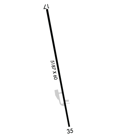
| Lat: N 4510.0 Long: W 08455.4 Elev: 719 Var: +06 Longest Runway: 5187 | ||
| CTAF: 122.8 | ||
| ||||||||||||||||||||||||||||||||||||||||||||
| ||||||||||||||||||||||||||||||||||||||||||||
| Rwy | Rwy | |||||||
| 5187x100 | 4887' | 5187x100 | 4687' | |||||
| Runway ID | Single Wheel | Double Wheel | Double Tandem Wheel | Dual Double Wheel |
| 17/35 | N/A | N/A | N/A | N/A |
| These numbers are Advisory and are not limits. The Airport Manager should have more accurate Weight Limits | ||||
 Airport Diagram might not be current. | |
| Facility Name: | BOYNE MOUNTAIN |
| City Name: | BOYNE FALLS |
| County: | CHARLEVOIX |
| State abbrev: | MI |
| State Name: | MICHIGAN |
| Ownership: | PRIVATELY OWNED |
| Use: | OPEN TO THE PUBLIC |
| Owner's Name: | BOYNE USA INC |
| Address: | 1 BOYNE MOUNTAIN RD |
| BOYNE FALLS, MI 49713-9642 | |
| Owner's Phone: | 231-549-6001 |
| Manager's Name: | CHRIS ADAMS |
| Address: | BOYNE MOUNTAIN RESORT, PO BOX 19 |
| BOYNE FALLS, MI 49713-0019 | |
| Phone: | 231-549-6852 |
| FAA Region: | GREAT LAKES |
| FAA Field Office: | DET |
| Date | Sunrise | Sunset |
|---|---|---|
| 03/15/25 Saturday | 7:53 | 19:45 |
| 03/16/25 Sunday | 7:51 | 19:47 |
| 03/17/25 Monday | 7:49 | 19:48 |
| 03/18/25 Tuesday | 7:47 | 19:49 |
| 03/19/25 Wednesday | 7:45 | 19:51 |
| 03/20/25 Thursday | 7:43 | 19:52 |
| 03/21/25 Friday | 7:41 | 19:53 |
| 03/22/25 Saturday | 7:40 | 19:55 |
| 03/23/25 Sunday | 7:38 | 19:56 |
| 03/24/25 Monday | 7:36 | 19:57 |
| 03/25/25 Tuesday | 7:34 | 19:58 |
| 03/26/25 Wednesday | 7:32 | 20:00 |
| 03/27/25 Thursday | 7:30 | 20:01 |
| 03/28/25 Friday | 7:28 | 20:02 |
| Airport Attendance Schedule | UNATTENDED |
| Airport Status | OPERATIONAL (This Status can change at any time - please check NOTAMS) |
| Airport Lighting Schedule | ACTVT REIL RWY 17 & 35; PAPI RWY 35; MIRL RWY 17/35 - CTAF. |
| Airport Storage Available | Tie Downs |
| Extra Services Available | NONE |
| Wind Indicator | YES - (lighted) |
| Control Tower | NO |
| CTAF Frequency | 122.800 |
| Unicom Frequency | 122.800 |
| Rotating Beacon Color | |
| Segmented Circle | YES |
| Landing Fee | YES; FOR LDG FEES CTC AMGR FOR DTLS. |
| Airport Inspected | STATE - performed by STATE AERONAUTICAL PERSONNEL |
| Inspection Date | 10/08/2024 |
| Type of Fuel Available | Grade 100LL; -10AVBL H24 SELF SVC VIA CREDIT CARD. |
| Airframe Repair Service | None |
| Power Plant Repair Service | None |
| Latitude | N4510.0 |
| Longitude | W08455.4 (ESTIMATED) |
| Arpt Elevation | 719ft (SURVEYED) |
| Magnetic Variation | 06W |
| 1 miles W | of BOYNE FALLS |
| Traffic Pattern Altitude | |
| Sectional Chart | LAKE HURON |
| Operations (Reported) | Yearly | Avg. Daily |
|---|---|---|
| General Aviation Transient | 0 | 0 |
| General Aviation Local | 0 | 0 |
| Air Taxi | 0 | 0 |
| Commerical | 0 | 0 |
| Commuter | 0 | 0 |
| Military | 0 | 0 |
| Aircraft based on Field | |
|---|---|
| General Aviation Singles | 0 |
| General Aviation Multi | 0 |
| Jet Aircraft | 0 |
| General Aviation Helicopters | 0 |
| Military Aircraft | 0 |
| Gliders | 0 |
| Ultralights | 0 |
| FSS on field | NO |
| FSS tie-in | LANSING |
| FSS Phone | 1-800-WX-BRIEF |
| Who issues Notams | LAN |
| Notam D service at airport | YES |
| ARTCC Name | MINNEAPOLIS |
| Airport Certification | |
| Aircraft Rescue & Firefighting Index | None |
| Airport of Entry | No |
| Custom Landing Rights | No |
| Joint Civil/Military | No |
| Military Landing rights | No |
| DEER, BIRDS, & WILDLIFE ON & INVOF ARPT. |
| FOR CD CTC MINNEAPOLIS ARTCC AT 651-463-5588. |
| RWY 17/35 TREES, BLDGS, & ROADS IN PRI SFC. |
| PEDESTRIANS INVOF RWY ENVIRONMENT - LODGING 200 FT WEST OF RWY 35 DESIGNATOR. |
Airport Communications & Frequencies:
| |||||||||
| Runway: 17 | Runway: 35 | ||
| Mag heading: | 175° | Mag heading: | 355° |
| Rwy Slope: | .31% Up | Rwy Slope: | -.31% Down |
| Approach: | Approach: | ||
| Pattern: | Left Traffic | Pattern: | Left Traffic |
| Markings: | NONPRECISION INSTRUMENT | Markings: | NONPRECISION INSTRUMENT |
| Marking Condition: | GOOD | Marking Condition: | GOOD |
| Arresting Dev: | Arresting Dev: | ||
| Lat & Long: | N4510.4 W08455.6 | Lat. & Long.: | N4509.5 W08455.3 |
| Elev: | 703.0 ft. MSL | Elev: | 719.0 ft. MSL |
| TCH: | TCH: | 40 ft. AGL | |
| Visual Glide Path: | Visual Glide Path: | 3.00 degrees | |
| Displaced Threshold: | 300 feet | Displaced Threshold: | 500 feet |
| Touchdown Zone: | YES | Touchdown Zone: | YES |
| Touchdown Elev.: | 707.0 feet | Touchdown Elev.: | 719.0 feet |
| Visual Glide Slope: | Visual Glide Slope: | 2-Light PAPI on LEFT side of Runway | |
| RVR Equipment: | RVR Equipment: | ||
| RVV Equipment: | NO | RVV Equipment: | NO |
| Approach Lights: | Approach Lights: | ||
| REIL: | YES | REIL: | YES |
| Centerline Lights: | NO | Centerline Lights: | NO |
| Touchdown lights: | NO | Touchdown lights: | NO |
| Runway Category: | Runway with a Non-precision Approach | Runway Category: | Runway with a Non-precision Approach |
| Declared Distances: | Declared Distances: | ||
| Obstructions: | ROAD | Obstructions: | TREES |
| Marked: | NOT Marked/Lighted | Marked: | NOT Marked/Lighted |
| Clearance slope: | APCH RATIO 20:1 TO DTHR OVR 15 FT ROAD, 300 FT DIST, 100 FT L. | Clearance slope: | APCH RATIO 11:1 TO DTHR OVR 44 FT TREES, 510 FT DIST, 166 FT R. |
| Obstruction height: | 15 feet AGL | Obstruction height: | 22 feet AGL |
| Dist. from runway: | 200 feet | Dist. from runway: | 200 feet |
| Centerline offset: | 55 right of centerline | Centerline offset: | 44 feet right of centerline |
| Comments: | +15 FT ROAD, 0-199 FT DIST, 100 FT L TO 90 FT R. | Comments: | +25 FT TREES, 200-500 FT DIST, 165 FT R. |
Thanks for using FltPlan.com
all rights reserved © 1999-2025 by Flight Plan LLC
