| JACK BROOKS REGIONAL AIRPORT BEAUMONT/PORT ARTHUR TX |
| |
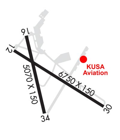
| Lat: N 2957.0 Long: W 09401.2 Elev: 15 Var: -01 Longest Runway: 6751 | ||
| Clr Del: 118.3 Dept. ATIS: 126.3 Arr. ATIS: 126.3 Ground: 124.85 Tower: 119.5 | ||
| |||||||||||||||||||||||||||||||||||||||
| |||||||||||||||||||||||||||||||||||||||
| |||||||||||||||||||||||||||||||||||||||
| |||||||||||||||||||||||||||||||||||||||
| Rwy | Rwy | |||||||
| 6751x150 | 6751' | 110.15 - 115° | 6751x150 | 6751' | ||||
| 5071x150 | 5071' | 5071x150 | 5071' | |||||
| Runway ID | Single Wheel | Double Wheel | Double Tandem Wheel | Dual Double Wheel |
| 12/30 | 90,000 | 170,000 | 230,000 | N/A |
| 16/34 | 70,000 | 90,000 | 145,000 | N/A |
| These numbers are Advisory and are not limits. The Airport Manager should have more accurate Weight Limits | ||||
 Airport Diagram might not be current. | |
| Facility Name: | JACK BROOKS RGNL |
| City Name: | BEAUMONT/PORT ARTHUR |
| County: | JEFFERSON |
| State abbrev: | TX |
| State Name: | TEXAS |
| Ownership: | PUBLICLY OWNED |
| Use: | OPEN TO THE PUBLIC |
| Owner's Name: | JEFFERSON COUNTY |
| Address: | 1149 PEARL ST 4TH FLOOR |
| BEAUMONT, TX 77701 | |
| Owner's Phone: | 409-835-8466 |
| Manager's Name: | ALEX RUPP |
| Address: | 5000 JERRY WARE DR SUITE 100 |
| BEAUMONT, TX 77705 | |
| Phone: | 409-719-4900 |
| FAA Region: | SOUTHWEST |
| FAA Field Office: | TEX |
| Date | Sunrise | Sunset |
|---|---|---|
| 03/17/25 Monday | 7:24 | 19:26 |
| 03/18/25 Tuesday | 7:23 | 19:26 |
| 03/19/25 Wednesday | 7:21 | 19:27 |
| 03/20/25 Thursday | 7:20 | 19:27 |
| 03/21/25 Friday | 7:19 | 19:28 |
| 03/22/25 Saturday | 7:18 | 19:29 |
| 03/23/25 Sunday | 7:17 | 19:29 |
| 03/24/25 Monday | 7:15 | 19:30 |
| 03/25/25 Tuesday | 7:14 | 19:31 |
| 03/26/25 Wednesday | 7:13 | 19:31 |
| 03/27/25 Thursday | 7:12 | 19:32 |
| 03/28/25 Friday | 7:11 | 19:32 |
| 03/29/25 Saturday | 7:09 | 19:33 |
| 03/30/25 Sunday | 7:08 | 19:34 |
| Airport Attendance Schedule | CONTINUOUS |
| Airport Status | OPERATIONAL (This Status can change at any time - please check NOTAMS) |
| Airport Lighting Schedule | DUSK-DAWN. WHEN ATCT CLSD REIL RWYS 16, 30 & 34; HIRL RWY 12/30 & 16/34 PRESET MED INTST. ACTVT MALSR RWY 12 - CTAF. |
| Airport Storage Available | Tie Downs, Hanger |
| Extra Services Available | Air Freight, Charter, Flight Instruction, Aircraft Rental |
| Wind Indicator | YES - (lighted) |
| Control Tower | YES |
| CTAF Frequency | 119.500 |
| Unicom Frequency | 122.950 |
| Rotating Beacon Color | WG |
| Segmented Circle | YES |
| Landing Fee | NO |
| Airport Inspected | FEDERAL - performed by FAA AIRPORTS FIELD PERSONNEL |
| Inspection Date | 12/05/2024 |
| Type of Fuel Available | Grade 100LL, JET A (freeze point -40C) |
| Airframe Repair Service | MINOR |
| Power Plant Repair Service | MINOR |
| Latitude | N2957.0 |
| Longitude | W09401.2 (ESTIMATED) |
| Arpt Elevation | 14ft (SURVEYED) |
| Magnetic Variation | 01E |
| 9 miles SE | of BEAUMONT/PORT ARTHUR |
| Traffic Pattern Altitude | |
| Sectional Chart | HOUSTON |
| Operations (Reported) | Yearly | Avg. Daily |
|---|---|---|
| General Aviation Transient | 0 | 0 |
| General Aviation Local | 0 | 0 |
| Air Taxi | 0 | 0 |
| Commerical | 0 | 0 |
| Commuter | 0 | 0 |
| Military | 0 | 0 |
| Aircraft based on Field | |
|---|---|
| General Aviation Singles | 0 |
| General Aviation Multi | 0 |
| Jet Aircraft | 0 |
| General Aviation Helicopters | 0 |
| Military Aircraft | 0 |
| Gliders | 0 |
| Ultralights | 0 |
| FSS on field | NO |
| FSS tie-in | MONTGOMERY COUNTY |
| FSS Phone | 1-800-WX-BRIEF |
| Who issues Notams | BPT |
| Notam D service at airport | YES |
| ARTCC Name | HOUSTON |
| Airport Certification | AIRPORT RECEIVING SCHEDULED AIR CARRIER SERVICE FROM CARRIERS CERTIFICATED BY THE CIVIL AERONAUTICS BOARD |
| Aircraft Rescue & Firefighting Index | AIRPORT HAS A CERTIFICATE UNDER CFR PART 139 |
| Airport of Entry | No |
| Custom Landing Rights | YES |
| Joint Civil/Military | No |
| Military Landing rights | YES |
| NATIONAL PLAN OF INTEGRATED AIRPORT SYSTEMS (NPIAS) |
| GRANT AGREEMENTS UNDER FAAP/ADAP/AIP |
| SURPLUS PROPERTY AGREEMENT UNDER PUBLIC LAW 289 |
| ASSURANCES PURSUANT TO TITLE VI, CIVIL RIGHTS ACT OF 1964 |
| AGREEMENT UNDER DLAND OR DCLA HAS EXPIRED. |
| BIRD ACTVTY ON & INVOF ARPT. |
| FOR CD WHEN ATCT IS CLSD CTC HOUSTON APCH AT 281-443-5844 TO CNL IFR AT 281-443-5888. |
| RWY 16/3 4 FIRST 1000 FT RWY 16 MUCH DARKER THAN REMAINDER OF RWY. |
| RWY 16/3 4 FIRST 4271 FT OF RWY 34 GRVD. |
| RWY 12/3 0 PCR VALUE: 578/R/C/W/T |
| RWY 16/3 4 PCR VALUE: 172/R/D/W/T |
Airport Communications & Frequencies:
| ||||||||||||||||||||||||||
| Runway: 12 | Runway: 30 | ||
| Mag heading: | 120° | Mag heading: | 300° |
| Rwy Slope: | -.13% Down | Rwy Slope: | .13% Up |
| Approach: | ILS/DME | Approach: | |
| Pattern: | Left Traffic | Pattern: | Left Traffic |
| Markings: | PRECISION INSTRUMENT | Markings: | PRECISION INSTRUMENT |
| Marking Condition: | GOOD | Marking Condition: | GOOD |
| Arresting Dev: | Arresting Dev: | ||
| Lat & Long: | N2957.3 W09401.7 | Lat. & Long.: | N2956.7 W09400.6 |
| Elev: | 14.4 ft. MSL | Elev: | 5.8 ft. MSL |
| TCH: | TCH: | 54 ft. AGL | |
| Visual Glide Path: | Visual Glide Path: | 3.00 degrees | |
| Displaced Threshold: | No | Displaced Threshold: | No |
| Touchdown Zone: | YES | Touchdown Zone: | YES |
| Touchdown Elev.: | 14.8 feet | Touchdown Elev.: | 11.7 feet |
| Visual Glide Slope: | Visual Glide Slope: | 4-BOX VASI ON LEFT SIDE OF RUNWAY | |
| RVR Equipment: | TOUCHDOWN | RVR Equipment: | ROLLOUT |
| RVV Equipment: | NO | RVV Equipment: | NO |
| Approach Lights: | MALSR - 1,400 foot medium intensity approach lighting system with runway alignment indicator lights | Approach Lights: | |
| REIL: | NO | REIL: | YES |
| Centerline Lights: | NO | Centerline Lights: | NO |
| Touchdown lights: | NO | Touchdown lights: | NO |
| Runway Category: | Precision Instrument Runway | Runway Category: | Runway with a Non-precision Approach having visibility minimums greater than 3/4 mile |
| Declared Distances: | TORA:6751' TODA:6751' ASDA:6508' LDA:6508' | Declared Distances: | TORA:6751' TODA:6751' ASDA:6751' LDA:6751' |
| Obstructions: | TREE | Obstructions: | TREE |
| Marked: | NOT Marked/Lighted | Marked: | NOT Marked/Lighted |
| Clearance slope: | 18:1 | Clearance slope: | 20:1 |
| Obstruction height: | 46 feet AGL | Obstruction height: | 41 feet AGL |
| Dist. from runway: | 1041 feet | Dist. from runway: | 1024 feet |
| Centerline offset: | 618 right of centerline | Centerline offset: | 529 feet right of centerline |
| Comments: | Comments: |
| Runway: 16 | Runway: 34 | ||
| Mag heading: | 165° | Mag heading: | 345° |
| Rwy Slope: | -.07% Down | Rwy Slope: | .07% Up |
| Approach: | Approach: | ||
| Pattern: | Left Traffic | Pattern: | Left Traffic |
| Markings: | NONPRECISION INSTRUMENT | Markings: | NONPRECISION INSTRUMENT |
| Marking Condition: | GOOD | Marking Condition: | GOOD |
| Arresting Dev: | Arresting Dev: | ||
| Lat & Long: | N2957.5 W09401.5 | Lat. & Long.: | N2956.7 W09401.3 |
| Elev: | 14.4 ft. MSL | Elev: | 10.9 ft. MSL |
| TCH: | 53 ft. AGL | TCH: | 53 ft. AGL |
| Visual Glide Path: | 3.00 degrees | Visual Glide Path: | 3.00 degrees |
| Displaced Threshold: | No | Displaced Threshold: | No |
| Touchdown Zone: | YES | Touchdown Zone: | YES |
| Touchdown Elev.: | 14.7 feet | Touchdown Elev.: | 14.4 feet |
| Visual Glide Slope: | 4-Light PAPI on RIGHT side of Runway | Visual Glide Slope: | 4-BOX VASI ON LEFT SIDE OF RUNWAY |
| RVR Equipment: | RVR Equipment: | ||
| RVV Equipment: | NO | RVV Equipment: | NO |
| Approach Lights: | Approach Lights: | ||
| REIL: | YES | REIL: | YES |
| Centerline Lights: | NO | Centerline Lights: | NO |
| Touchdown lights: | NO | Touchdown lights: | NO |
| Runway Category: | Runway with a Non-precision Approach having visibility minimums greater than 3/4 mile | Runway Category: | Runway with a Non-precision Approach having visibility minimums greater than 3/4 mile |
| Declared Distances: | TORA:5070' TODA:5070' ASDA:5070' LDA:5070' | Declared Distances: | TORA:5070' TODA:5070' ASDA:5070' LDA:5070' |
Thanks for using FltPlan.com
all rights reserved © 1999-2025 by Flight Plan LLC