
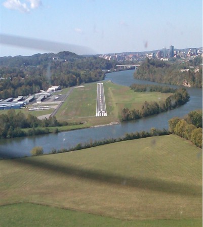
| KNOXVILLE DOWNTOWN ISLAND KNOXVILLE TN |
| |
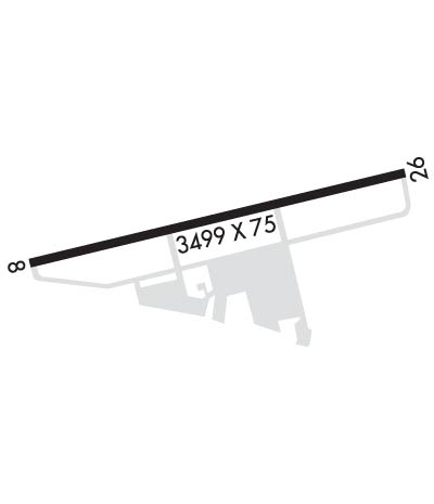
| Lat: N 3557.8 Long: W 08352.4 Elev: 833 Var: +05 Longest Runway: 3499 | ||
| Clr Del: 121.7 AWOS: 125.37 CTAF: 126.60 | ||
| ||||||
| ||||||
|
| Rwy | Rwy | |||||||
| 3499x75 | 3499' | 3499x75 | 3499' | 111.30 - 260° | ||||
| Runway ID | Single Wheel | Double Wheel | Double Tandem Wheel | Dual Double Wheel |
| 08/26 | 22,000 | N/A | N/A | N/A |
| These numbers are Advisory and are not limits. The Airport Manager should have more accurate Weight Limits | ||||
 Airport Diagram might not be current. | |
| Facility Name: | KNOXVILLE DOWNTOWN ISLAND |
| City Name: | KNOXVILLE |
| County: | KNOX |
| State abbrev: | TN |
| State Name: | TENNESSEE |
| Ownership: | PUBLICLY OWNED |
| Use: | OPEN TO THE PUBLIC |
| Owner's Name: | KNOXVILLE METRO ARPT AUTH |
| Address: | PO BOX 15600 |
| KNOXVILLE, TN 37901 | |
| Owner's Phone: | 865-342-3000 |
| Manager's Name: | BRIAN SHUTT |
| Address: | 2701 SPENCE PLACE |
| KNOXVILLE, TN 37920 | |
| Phone: | (865) 342-3182 |
| FAA Region: | SOUTHERN |
| FAA Field Office: | MEM |
| Date | Sunrise | Sunset |
|---|---|---|
| 09/24/21 Friday | 7:25 | 19:30 |
| 09/25/21 Saturday | 7:26 | 19:28 |
| 09/26/21 Sunday | 7:26 | 19:27 |
| 09/27/21 Monday | 7:27 | 19:25 |
| 09/28/21 Tuesday | 7:28 | 19:24 |
| 09/29/21 Wednesday | 7:29 | 19:22 |
| 09/30/21 Thursday | 7:30 | 19:21 |
| 10/01/21 Friday | 7:30 | 19:19 |
| 10/02/21 Saturday | 7:31 | 19:18 |
| 10/03/21 Sunday | 7:32 | 19:17 |
| 10/04/21 Monday | 7:33 | 19:15 |
| 10/05/21 Tuesday | 7:34 | 19:14 |
| 10/06/21 Wednesday | 7:34 | 19:12 |
| 10/07/21 Thursday | 7:35 | 19:11 |
| Airport Attendance Schedule | 7 Days A Week 0700-2200 |
| Airport Status | OPERATIONAL (This Status can change at any time - please check NOTAMS) |
| Airport Lighting Schedule | DUSK-DAWN; MIRL RWY 08/26; REIL RWY 08 & 26 & TWY LGTS PRESET LOW INTST; INCR INTST - CTAF. |
| Airport Storage Available | Tie Downs |
| Extra Services Available | Air Ambulance, Charter, Glider, Flight Instruction, Aircraft Rental, Glider Towing |
| Wind Indicator | YES - (lighted) |
| Control Tower | NO |
| CTAF Frequency | 126.600 |
| Unicom Frequency | 122.950 |
| Rotating Beacon Color | CLEAR-GREEN (Light Land Airport) |
| Segmented Circle | YES |
| Landing Fee | NO |
| Airport Inspected | STATE - performed by STATE AERONAUTICAL PERSONNEL |
| Inspection Date | 09/11/2019 |
| Type of Fuel Available | Grade 100LL, JET A; -10100LL SELF SERV H24 WITH CREDIT CARD. |
| Airframe Repair Service | MAJOR |
| Power Plant Repair Service | MAJOR |
| Latitude | N3557.8 |
| Longitude | W08352.4 (ESTIMATED) |
| Arpt Elevation | 833ft (SURVEYED) |
| Magnetic Variation | 05W |
| 3 miles E | of KNOXVILLE |
| Traffic Pattern Altitude | |
| Sectional Chart | ATLANTA |
| Operations (Reported) | Yearly | Avg. Daily |
|---|---|---|
| General Aviation Transient | 35000 | 96 |
| General Aviation Local | 36000 | 99 |
| Air Taxi | 400 | 1 |
| Commerical | 0 | 0 |
| Commuter | 0 | 0 |
| Military | 0 | 0 |
| Aircraft based on Field | |
|---|---|
| General Aviation Singles | 110 |
| General Aviation Multi | 19 |
| Jet Aircraft | 0 |
| General Aviation Helicopters | 6 |
| Military Aircraft | 0 |
| Gliders | 2 |
| Ultralights | 0 |
| FSS on field | NO |
| FSS tie-in | NASHVILLE |
| FSS Phone | 1-800-WX-BRIEF |
| Who issues Notams | BNA |
| Notam D service at airport | YES |
| ARTCC Name | ATLANTA |
| Airport Certification | |
| Aircraft Rescue & Firefighting Index | None |
| Airport of Entry | No |
| Custom Landing Rights | No |
| Joint Civil/Military | No |
| Military Landing rights | YES |
| NATIONAL PLAN OF INTEGRATED AIRPORT SYSTEMS (NPIAS) |
| GRANT AGREEMENTS UNDER FAAP/ADAP/AIP |
| ASSURANCES PURSUANT TO TITLE VI, CIVIL RIGHTS ACT OF 1964 |
| GEESE ON & INVOF ARPT. |
| TFR MAY BE IN EFFECT OVER STADIUM 2.5 MILES W - CALL 865-577-4461 FOR TIMES. |
| FOR CD CTC KNOXVILLE APCH AT 865-980-3034; IF UNA FOR CD CTC KNOXVILLE APCH AT 865-980-3033. |
| RWY 08 CALM WIND RWY. |
| RWY 26 DEP AVOID TURNS OVER NEIGHBORHOOD 1 NM SW OF ARPT. NOISE SENSITIVE AREA. |
Airport Communications & Frequencies:
| ||||||||||||||||
| Runway: 08 | Runway: 26 | ||
| Mag heading: | 80° | Mag heading: | 260° |
| Rwy Slope: | -.07% Down | Rwy Slope: | .07% Up |
| Approach: | Approach: | LOCALIZER | |
| Pattern: | Left Traffic | Pattern: | Left Traffic |
| Markings: | NONPRECISION INSTRUMENT | Markings: | NONPRECISION INSTRUMENT |
| Marking Condition: | FAIR | Marking Condition: | FAIR |
| Arresting Dev: | Arresting Dev: | ||
| Lat & Long: | N3557.8 W08352.8 | Lat. & Long.: | N3557.9 W08352.1 |
| Elev: | 833.0 ft. MSL | Elev: | 830.7 ft. MSL |
| TCH: | 43 ft. AGL | TCH: | 44 ft. AGL |
| Visual Glide Path: | 3.80 degrees | Visual Glide Path: | 3.35 degrees |
| Displaced Threshold: | No | Displaced Threshold: | No |
| Touchdown Zone: | YES | Touchdown Zone: | YES |
| Touchdown Elev.: | 833.2 feet | Touchdown Elev.: | 832.4 feet |
| Visual Glide Slope: | 2-Light PAPI on LEFT side of Runway | Visual Glide Slope: | 2-Light PAPI on LEFT side of Runway |
| RVR Equipment: | RVR Equipment: | ||
| RVV Equipment: | NO | RVV Equipment: | NO |
| Approach Lights: | Approach Lights: | ||
| REIL: | YES | REIL: | YES |
| Centerline Lights: | NO | Centerline Lights: | NO |
| Touchdown lights: | NO | Touchdown lights: | NO |
| Runway Category: | Runway with a Visual Approach | Runway Category: | Runway with a Non-precision Approach |
| Declared Distances: | Declared Distances: |
Thanks for using FltPlan.com
all rights reserved © 1999-2021 by Flight Plan LLC