| DUPAGE CHICAGO/WEST CHICAGO IL |
| |
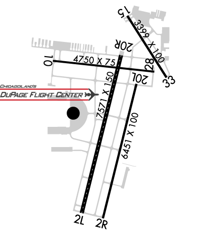
| Lat: N 4154.4 Long: W 08814.9 Elev: 759 Var: +01 Longest Runway: 7571 | ||
| Clr Del: 119.75 Dept. ATIS: 132.07 Arr. ATIS: 132.07 Ground: 121.8 Tower: 120.9/124.5 | ||
| |||||||||||||||||||||||||||||||||||||||||||||||||||||||||||||||||||||
| |||||||||||||||||||||||||||||||||||||||||||||||||||||||||||||||||||||
| |||||||||||||||||||||||||||||||||||||||||||||||||||||||||||||||||||||
| Rwy | Rwy | |||||||
| 7571x150 | 7571' | 111.70 - 015° | 7571x150 | 7571' | ||||
| 6451x100 | 6451' | 6451x100 | 6451' | |||||
| 4750x75 | 4750' | 109.50 - 097° | 4750x75 | 4750' | ||||
| 3399x100 | 3399' | 3399x100 | 3209' | |||||
| Runway ID | Single Wheel | Double Wheel | Double Tandem Wheel | Dual Double Wheel |
| 02L/20R | 30,000 | 45,000 | N/A | N/A |
| 02R/20L | 30,000 | 45,000 | N/A | N/A |
| 10/28 | 30,000 | 45,000 | N/A | N/A |
| 15/33 | 30,000 | 45,000 | 100,000 | N/A |
| These numbers are Advisory and are not limits. The Airport Manager should have more accurate Weight Limits | ||||
 Airport Diagram might not be current. | |
| Facility Name: | DUPAGE |
| City Name: | CHICAGO/WEST CHICAGO |
| County: | DU PAGE |
| State abbrev: | IL |
| State Name: | ILLINOIS |
| Ownership: | PUBLICLY OWNED |
| Use: | OPEN TO THE PUBLIC |
| Owner's Name: | DUPAGE ARPT AUTH |
| Address: | 2700 INTERNATIONAL DRIVE STE 200 |
| WEST CHICAGO, IL 60185-0787 | |
| Owner's Phone: | 630-584-2211 |
| Manager's Name: | MARK DOLES |
| Address: | 2700 INT'L DRIVE, STE 200; EMAIL ADDRESS: MDOLES@DUPAGEAIRPORT.COM (ALL LOWER CASE) |
| WEST CHICAGO, IL 60185-0787 | |
| Phone: | 630-584-2211 |
| FAA Region: | GREAT LAKES |
| FAA Field Office: | CHI |
| Date | Sunrise | Sunset |
|---|---|---|
| 09/24/21 Friday | 6:42 | 18:47 |
| 09/25/21 Saturday | 6:43 | 18:45 |
| 09/26/21 Sunday | 6:44 | 18:44 |
| 09/27/21 Monday | 6:45 | 18:42 |
| 09/28/21 Tuesday | 6:46 | 18:40 |
| 09/29/21 Wednesday | 6:47 | 18:38 |
| 09/30/21 Thursday | 6:49 | 18:37 |
| 10/01/21 Friday | 6:50 | 18:35 |
| 10/02/21 Saturday | 6:51 | 18:33 |
| 10/03/21 Sunday | 6:52 | 18:32 |
| 10/04/21 Monday | 6:53 | 18:30 |
| 10/05/21 Tuesday | 6:54 | 18:28 |
| 10/06/21 Wednesday | 6:55 | 18:27 |
| 10/07/21 Thursday | 6:56 | 18:25 |
| Airport Attendance Schedule | CONTINUOUS |
| Airport Status | OPERATIONAL (This Status can change at any time - please check NOTAMS) |
| Airport Lighting Schedule | ATC-CTL |
| Airport Storage Available | Tie Downs, Hanger |
| Extra Services Available | Air Freight, Avionics, Cargo Handling, Charter, Flight Instruction, Aircraft Rental, Aircraft Sales |
| Wind Indicator | YES - (lighted) |
| Control Tower | YES |
| CTAF Frequency | |
| Unicom Frequency | 122.950 |
| Rotating Beacon Color | CLEAR-GREEN (Light Land Airport) |
| Segmented Circle | NO |
| Landing Fee | NO |
| Airport Inspected | STATE - performed by STATE AERONAUTICAL PERSONNEL |
| Inspection Date | 08/20/2020 |
| Type of Fuel Available | Grade 100LL, JET A (freeze point -40C); -10100LL SELF SERVICE AVAILABLE 24HR WITH CREDIT CARD |
| Airframe Repair Service | MAJOR |
| Power Plant Repair Service | MAJOR |
| Latitude | N4154.4 |
| Longitude | W08814.9 (ESTIMATED) |
| Arpt Elevation | 758ft (SURVEYED) |
| Magnetic Variation | 01W |
| 29 miles W | of CHICAGO/WEST CHICAGO |
| Traffic Pattern Altitude | |
| Sectional Chart | CHICAGO |
| Operations (Reported) | Yearly | Avg. Daily |
|---|---|---|
| General Aviation Transient | 50356 | 138 |
| General Aviation Local | 77275 | 212 |
| Air Taxi | 5244 | 14 |
| Commerical | 0 | 0 |
| Commuter | 0 | 0 |
| Military | 235 | 1 |
| Aircraft based on Field | |
|---|---|
| General Aviation Singles | 160 |
| General Aviation Multi | 31 |
| Jet Aircraft | 60 |
| General Aviation Helicopters | 4 |
| Military Aircraft | 0 |
| Gliders | 0 |
| Ultralights | 0 |
| FSS on field | NO |
| FSS tie-in | KANKAKEE |
| FSS Phone | 1-800-WX-BRIEF |
| Who issues Notams | DPA |
| Notam D service at airport | YES |
| ARTCC Name | CHICAGO |
| Airport Certification | |
| Aircraft Rescue & Firefighting Index | ARFF INDEX B PPR |
| Airport of Entry | No |
| Custom Landing Rights | No; US CUSTOMS USER FEE ARPT. |
| Joint Civil/Military | No |
| Military Landing rights | YES |
| NATIONAL PLAN OF INTEGRATED AIRPORT SYSTEMS (NPIAS) |
| GRANT AGREEMENTS UNDER FAAP/ADAP/AIP |
| SURPLUS PROPERTY AGREEMENT UNDER REGULATION 16-WAA |
| ASSURANCES PURSUANT TO TITLE VI, CIVIL RIGHTS ACT OF 1964 |
| DEER, COYOTE, BIRDS & MIGRATORY WATERFOWL ON & INVOF ARPT. |
| ACFT ON SHORT FINAL TO RY 15 ARE NOT VSB FROM ATCT DUE TO TREES. |
| ARFF INDEX B PPR |
| US CUST SVC AVBL PPR. |
| INT DEP RWY 20R AT TWY G HAS 6141'. |
Airport Communications & Frequencies:
| |||||||||||||||||||||||||||
| Runway: 02L | Runway: 20R | ||
| Mag heading: | 15° | Mag heading: | 195° |
| Rwy Slope: | .06% Up | Rwy Slope: | -.06% Down |
| Approach: | ILS | Approach: | |
| Pattern: | Left Traffic | Pattern: | Left Traffic |
| Markings: | PRECISION INSTRUMENT | Markings: | PRECISION INSTRUMENT |
| Marking Condition: | GOOD | Marking Condition: | GOOD |
| Arresting Dev: | Arresting Dev: | ||
| Lat & Long: | N4153.6 W08815.2 | Lat. & Long.: | N4154.9 W08814.8 |
| Elev: | 750.8 ft. MSL | Elev: | 755.5 ft. MSL |
| TCH: | TCH: | 40 ft. AGL | |
| Visual Glide Path: | Visual Glide Path: | 3.00 degrees | |
| Displaced Threshold: | No | Displaced Threshold: | No |
| Touchdown Zone: | YES | Touchdown Zone: | YES |
| Touchdown Elev.: | 753.7 feet | Touchdown Elev.: | 757.1 feet |
| Visual Glide Slope: | Visual Glide Slope: | 4-Light PAPI on LEFT side of Runway | |
| RVR Equipment: | TOUCHDOWN | RVR Equipment: | ROLLOUT |
| RVV Equipment: | NO | RVV Equipment: | NO |
| Approach Lights: | MALSR - 1,400 foot medium intensity approach lighting system with runway alignment indicator lights | Approach Lights: | |
| REIL: | NO | REIL: | NO |
| Centerline Lights: | YES | Centerline Lights: | YES |
| Touchdown lights: | YES | Touchdown lights: | NO |
| Runway Category: | Precision Instrument Runway | Runway Category: | Runway with a Non-precision Approach having visibility minimums greater than 3/4 mile |
| Declared Distances: | Declared Distances: |
| Runway: 02R | Runway: 20L | ||
| Mag heading: | 15° | Mag heading: | 195° |
| Rwy Slope: | .12% Up | Rwy Slope: | -.12% Down |
| Approach: | Approach: | ||
| Pattern: | Right Traffic | Pattern: | Left Traffic |
| Markings: | NONPRECISION INSTRUMENT | Markings: | NONPRECISION INSTRUMENT |
| Marking Condition: | GOOD | Marking Condition: | GOOD |
| Arresting Dev: | Arresting Dev: | ||
| Lat & Long: | N4153.6 W08815.0 | Lat. & Long.: | N4154.6 W08814.7 |
| Elev: | 750.5 ft. MSL | Elev: | 758.5 ft. MSL |
| TCH: | TCH: | ||
| Visual Glide Path: | Visual Glide Path: | ||
| Displaced Threshold: | No | Displaced Threshold: | No |
| Touchdown Zone: | YES | Touchdown Zone: | YES |
| Touchdown Elev.: | 751.1 feet | Touchdown Elev.: | 758.5 feet |
| Visual Glide Slope: | Visual Glide Slope: | ||
| RVR Equipment: | RVR Equipment: | ||
| RVV Equipment: | NO | RVV Equipment: | NO |
| Approach Lights: | Approach Lights: | ||
| REIL: | NO | REIL: | NO |
| Centerline Lights: | NO | Centerline Lights: | NO |
| Touchdown lights: | NO | Touchdown lights: | NO |
| Runway Category: | Runway with a Non-precision Approach having visibility minimums greater than 3/4 mile | Runway Category: | Runway with a Non-precision Approach having visibility minimums greater than 3/4 mile |
| Declared Distances: | Declared Distances: |
| Runway: 10 | Runway: 28 | ||
| Mag heading: | 97° | Mag heading: | 277° |
| Rwy Slope: | .05% Up | Rwy Slope: | -.05% Down |
| Approach: | ILS | Approach: | |
| Pattern: | Left Traffic | Pattern: | Left Traffic |
| Markings: | PRECISION INSTRUMENT | Markings: | PRECISION INSTRUMENT |
| Marking Condition: | GOOD | Marking Condition: | GOOD |
| Arresting Dev: | Arresting Dev: | ||
| Lat & Long: | N4154.8 W08815.5 | Lat. & Long.: | N4154.7 W08814.5 |
| Elev: | 753.3 ft. MSL | Elev: | 755.9 ft. MSL |
| TCH: | 50 ft. AGL | TCH: | 40 ft. AGL |
| Visual Glide Path: | 3.00 degrees | Visual Glide Path: | 3.00 degrees |
| Displaced Threshold: | No | Displaced Threshold: | No |
| Touchdown Zone: | YES | Touchdown Zone: | YES |
| Touchdown Elev.: | 756.3 feet | Touchdown Elev.: | 756.6 feet |
| Visual Glide Slope: | 4-BOX VASI ON LEFT SIDE OF RUNWAY; UNUSBL BYD 5 DEG RIGHT AND LEFT OF CNTRLN. | Visual Glide Slope: | 4-Light PAPI on LEFT side of Runway |
| RVR Equipment: | RVR Equipment: | ||
| RVV Equipment: | NO | RVV Equipment: | NO |
| Approach Lights: | RLLS | Approach Lights: | |
| REIL: | YES | REIL: | YES |
| Centerline Lights: | NO | Centerline Lights: | NO |
| Touchdown lights: | NO | Touchdown lights: | NO |
| Runway Category: | Precision Instrument Runway | Runway Category: | Runway with a Visual Approach |
| Declared Distances: | Declared Distances: | ||
| Obstructions: | BLDG | Obstructions: | |
| Marked: | NOT Marked/Lighted | Marked: | |
| Clearance slope: | 44:1 | Clearance slope: | 20:1 |
| Obstruction height: | 34 feet AGL | Obstruction height: | |
| Dist. from runway: | 1743 feet | Dist. from runway: | |
| Centerline offset: | Centerline offset: | ||
| Comments: | Comments: |
| Runway: 15 | Runway: 33 | ||
| Mag heading: | 149° | Mag heading: | 329° |
| Rwy Slope: | .02% Up | Rwy Slope: | -.02% Down |
| Approach: | Approach: | ||
| Pattern: | Left Traffic | Pattern: | Left Traffic |
| Markings: | BASIC | Markings: | BASIC |
| Marking Condition: | GOOD | Marking Condition: | GOOD |
| Arresting Dev: | Arresting Dev: | ||
| Lat & Long: | N4155.2 W08814.7 | Lat. & Long.: | N4154.7 W08814.3 |
| Elev: | 756.9 ft. MSL | Elev: | 757.6 ft. MSL |
| TCH: | 42 ft. AGL | TCH: | |
| Visual Glide Path: | 3.90 degrees | Visual Glide Path: | |
| Displaced Threshold: | No | Displaced Threshold: | 190 feet |
| Touchdown Zone: | YES | Touchdown Zone: | YES |
| Touchdown Elev.: | 757.2 feet | Touchdown Elev.: | 757.8 feet |
| Visual Glide Slope: | 4-Light PAPI on RIGHT side of Runway | Visual Glide Slope: | |
| RVR Equipment: | RVR Equipment: | ||
| RVV Equipment: | NO | RVV Equipment: | NO |
| Approach Lights: | Approach Lights: | ||
| REIL: | YES | REIL: | YES |
| Centerline Lights: | NO | Centerline Lights: | NO |
| Touchdown lights: | NO | Touchdown lights: | NO |
| Runway Category: | Runway with a Visual Approach | Runway Category: | Runway with a Visual Approach |
| Declared Distances: | Declared Distances: | ||
| Obstructions: | TREE | Obstructions: | TREE |
| Marked: | NOT Marked/Lighted | Marked: | NOT Marked/Lighted |
| Clearance slope: | 18:1 | Clearance slope: | 12:1; APCH RATIO IS 20:1 TO DSPLCD THLD. |
| Obstruction height: | 86 feet AGL | Obstruction height: | 54 feet AGL |
| Dist. from runway: | 1750 feet | Dist. from runway: | 893 feet |
| Centerline offset: | 205 right of centerline | Centerline offset: | 183 feet left of centerline |
| Comments: | Comments: | +13 FT ROAD 199 FT FM RY END 125 FT R. |
Thanks for using FltPlan.com
all rights reserved © 1999-2021 by Flight Plan LLC