
| DETROIT LAKES-WETHING FIELD DETROIT LAKES MN |
| |
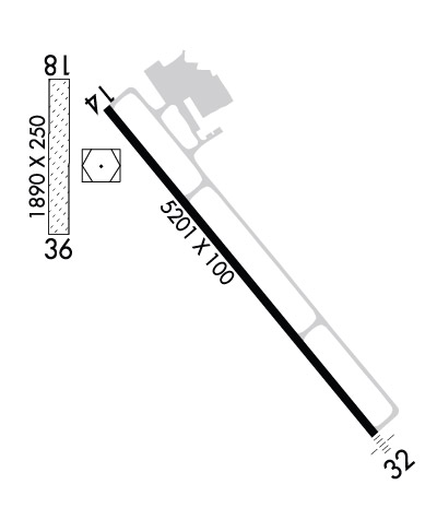
| Lat: N 4649.4 Long: W 09553.0 Elev: 1396 Var: -02 Longest Runway: 5201 | ||
| AWOS: 111.2 CTAF: 122.8 | ||
| ||||||
| ||||||
|
| Rwy | Rwy | |||||||
| 5201x100 | 5201' | 5201x100 | 5201' | |||||
| 1890x250 | 1890' | 1890x250 | 1890' | |||||
| Runway ID | Single Wheel | Double Wheel | Double Tandem Wheel | Dual Double Wheel |
| 14/32 | 23,000 | 42,000 | N/A | N/A |
| 18/36 | N/A | N/A | N/A | N/A |
| These numbers are Advisory and are not limits. The Airport Manager should have more accurate Weight Limits | ||||
 Airport Diagram might not be current. | |
| Facility Name: | DETROIT LAKES/WETHING FLD |
| City Name: | DETROIT LAKES |
| County: | BECKER |
| State abbrev: | MN |
| State Name: | MINNESOTA |
| Ownership: | PUBLICLY OWNED |
| Use: | OPEN TO THE PUBLIC |
| Owner's Name: | CITY OF DETROIT LAKES; OWNED ALSO BY BECKER COUNTY. |
| Address: | 1025 ROOSEVELT AVE, PO BOX 647 |
| DETROIT LAKES, MN 56501 | |
| Owner's Phone: | 218-847-5658 |
| Manager's Name: | ERIK CARLSON |
| Address: | 1817 US HWY 10 W |
| DETROIT LAKES, MN 56501-7979 | |
| Phone: | 218-841-8233 |
| FAA Region: | GREAT LAKES |
| FAA Field Office: | DMA |
| Date | Sunrise | Sunset |
|---|---|---|
| 04/25/25 Friday | 6:19 | 20:25 |
| 04/26/25 Saturday | 6:17 | 20:27 |
| 04/27/25 Sunday | 6:15 | 20:28 |
| 04/28/25 Monday | 6:14 | 20:29 |
| 04/29/25 Tuesday | 6:12 | 20:31 |
| 04/30/25 Wednesday | 6:10 | 20:32 |
| 05/01/25 Thursday | 6:09 | 20:33 |
| 05/02/25 Friday | 6:07 | 20:35 |
| 05/03/25 Saturday | 6:06 | 20:36 |
| 05/04/25 Sunday | 6:04 | 20:37 |
| 05/05/25 Monday | 6:03 | 20:39 |
| 05/06/25 Tuesday | 6:01 | 20:40 |
| 05/07/25 Wednesday | 6:00 | 20:41 |
| 05/08/25 Thursday | 5:58 | 20:43 |
| Airport Attendance Schedule | MON-FRI 0800-1700 |
| Airport Status | OPERATIONAL (This Status can change at any time - please check NOTAMS) |
| Airport Lighting Schedule | ACTVT MALSF RWY 32; REIL RWY 14; HIRL RWY 14/32 - CTAF. PAPI RWY 14 & 32 OPR CONSLY. |
| Airport Storage Available | Tie Downs, Hanger |
| Extra Services Available | Aircraft Sales |
| Wind Indicator | YES - (lighted) |
| Control Tower | NO |
| CTAF Frequency | 122.800 |
| Unicom Frequency | 122.800 |
| Rotating Beacon Color | WG |
| Segmented Circle | YES |
| Landing Fee | NO |
| Airport Inspected | STATE - performed by STATE AERONAUTICAL PERSONNEL |
| Inspection Date | 07/02/2024 |
| Type of Fuel Available | Grade 100LL, JET A (freeze point -40C); -10100LL AVBL H24 SELF SVC. FOR JET A SVC AFT HRS CALL AMGR. |
| Airframe Repair Service | MAJOR |
| Power Plant Repair Service | MAJOR |
| Latitude | N4649.4 |
| Longitude | W09553.0 (ESTIMATED) |
| Arpt Elevation | 1395ft (SURVEYED) |
| Magnetic Variation | 02E |
| 2 miles W | of DETROIT LAKES |
| Traffic Pattern Altitude | |
| Sectional Chart | TWIN CITIES |
| Operations (Reported) | Yearly | Avg. Daily |
|---|---|---|
| General Aviation Transient | 0 | 0 |
| General Aviation Local | 0 | 0 |
| Air Taxi | 0 | 0 |
| Commerical | 0 | 0 |
| Commuter | 0 | 0 |
| Military | 0 | 0 |
| Aircraft based on Field | |
|---|---|
| General Aviation Singles | 0 |
| General Aviation Multi | 0 |
| Jet Aircraft | 0 |
| General Aviation Helicopters | 0 |
| Military Aircraft | 0 |
| Gliders | 0 |
| Ultralights | 0 |
| FSS on field | NO |
| FSS tie-in | PRINCETON |
| FSS Phone | 1-800-WX-BRIEF |
| Who issues Notams | DTL |
| Notam D service at airport | YES |
| ARTCC Name | MINNEAPOLIS |
| Airport Certification | |
| Aircraft Rescue & Firefighting Index | None |
| Airport of Entry | No |
| Custom Landing Rights | No |
| Joint Civil/Military | No |
| Military Landing rights | YES |
| NATIONAL PLAN OF INTEGRATED AIRPORT SYSTEMS (NPIAS) |
| GRANT AGREEMENTS UNDER FAAP/ADAP/AIP |
| ASSURANCES PURSUANT TO TITLE VI, CIVIL RIGHTS ACT OF 1964 |
| FOR CD IF UNA TO CTC ON FSS FREQ, CTC MINNEAPOLIS ARTCC AT 651-463-5588. |
| RWY 18/3 6 NOT PLOWED WINTER MONTHS. |
Airport Communications & Frequencies:
| |||||||||
| Runway: 14 | Runway: 32 | ||
| Mag heading: | 138° | Mag heading: | 318° |
| Rwy Slope: | -.59% Down | Rwy Slope: | .59% Up |
| Approach: | Approach: | ||
| Pattern: | Left Traffic | Pattern: | Left Traffic |
| Markings: | PRECISION INSTRUMENT | Markings: | PRECISION INSTRUMENT |
| Marking Condition: | GOOD | Marking Condition: | GOOD |
| Arresting Dev: | Arresting Dev: | ||
| Lat & Long: | N4649.6 W09553.2 | Lat. & Long.: | N4649.0 W09552.4 |
| Elev: | 1392.8 ft. MSL | Elev: | 1362.0 ft. MSL |
| TCH: | 43 ft. AGL | TCH: | 42 ft. AGL |
| Visual Glide Path: | 3.00 degrees | Visual Glide Path: | 3.00 degrees |
| Displaced Threshold: | No | Displaced Threshold: | No |
| Touchdown Zone: | YES | Touchdown Zone: | YES |
| Touchdown Elev.: | 1392.8 feet | Touchdown Elev.: | 1371.5 feet |
| Visual Glide Slope: | 4-Light PAPI on LEFT side of Runway | Visual Glide Slope: | 4-Light PAPI on LEFT side of Runway |
| RVR Equipment: | RVR Equipment: | ||
| RVV Equipment: | NO | RVV Equipment: | NO |
| Approach Lights: | Approach Lights: | MALSF - 1,400 foot medium intensity approach lighting system with sequenced flashers | |
| REIL: | YES | REIL: | NO |
| Centerline Lights: | NO | Centerline Lights: | NO |
| Touchdown lights: | NO | Touchdown lights: | NO |
| Runway Category: | Runway with a Non-precision Approach having visibility minimums greater than 3/4 mile | Runway Category: | D |
| Declared Distances: | Declared Distances: |
| Runway: 18 | Runway: 36 | ||
| Mag heading: | 178° | Mag heading: | 358° |
| Rwy Slope: | -1.21% Down | Rwy Slope: | 1.21% Up |
| Approach: | Approach: | ||
| Pattern: | Left Traffic | Pattern: | Left Traffic |
| Markings: | Markings: | ||
| Marking Condition: | CONES. | Marking Condition: | CONES. |
| Arresting Dev: | Arresting Dev: | ||
| Lat & Long: | N4649.7 W09553.4 | Lat. & Long.: | N4649.4 W09553.4 |
| Elev: | 1395.9 ft. MSL | Elev: | 1373.0 ft. MSL |
| TCH: | TCH: | ||
| Visual Glide Path: | Visual Glide Path: | ||
| Displaced Threshold: | No | Displaced Threshold: | No |
| Touchdown Zone: | YES | Touchdown Zone: | YES |
| Touchdown Elev.: | 1395.9 feet | Touchdown Elev.: | 1395.9 feet |
| Visual Glide Slope: | Visual Glide Slope: | ||
| RVR Equipment: | RVR Equipment: | ||
| RVV Equipment: | NO | RVV Equipment: | NO |
| Approach Lights: | Approach Lights: | ||
| REIL: | NO | REIL: | NO |
| Centerline Lights: | NO | Centerline Lights: | NO |
| Touchdown lights: | NO | Touchdown lights: | NO |
| Runway Category: | Runway with a Visual Approach | Runway Category: | Runway with a Visual Approach |
| Declared Distances: | Declared Distances: | ||
| Obstructions: | Obstructions: | TREES | |
| Marked: | Marked: | NOT Marked/Lighted | |
| Clearance slope: | 20:1 | Clearance slope: | 13:1 |
| Obstruction height: | Obstruction height: | 45 feet AGL | |
| Dist. from runway: | Dist. from runway: | 618 feet | |
| Centerline offset: | Centerline offset: | 176 feet left of centerline | |
| Comments: | Comments: |
Thanks for using FltPlan.com
all rights reserved © 1999-2025 by Flight Plan LLC
