
| GNOSS FIELD NOVATO CA |
| |
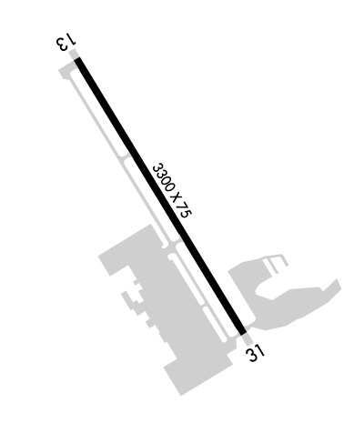
| Lat: N 3808.6 Long: W 12233.4 Elev: 4 Var: -16 Longest Runway: 3300 | ||
| AWOS: 120.67 CTAF: 123.07 | ||
| ||||||||||||||||||||||||||||||||||||||||||||
| ||||||||||||||||||||||||||||||||||||||||||||
| ||||||||||||||||||||||||||||||||||||||||||||
| Rwy | Rwy | |||||||
| 3300x75 | 3300' | 3300x75 | 3300' | |||||
| Runway ID | Single Wheel | Double Wheel | Double Tandem Wheel | Dual Double Wheel |
| 13/31 | 26,000 | N/A | N/A | N/A |
| H1 | N/A | N/A | N/A | N/A |
| These numbers are Advisory and are not limits. The Airport Manager should have more accurate Weight Limits | ||||
 Airport Diagram might not be current. | |
| Facility Name: | GNOSS FLD |
| City Name: | NOVATO |
| County: | MARIN |
| State abbrev: | CA |
| State Name: | CALIFORNIA |
| Ownership: | PUBLICLY OWNED |
| Use: | OPEN TO THE PUBLIC |
| Owner's Name: | MARIN COUNTY |
| Address: | P.O. BOX 4055 |
| SAN RAFAEL, CA 94913-4055 | |
| Owner's Phone: | 415-897-1754 |
| Manager's Name: | DAN JENSEN |
| Address: | 451 #A AIRPORT ROAD |
| NOVATO, CA 94945 | |
| Phone: | 415-897-1754 |
| FAA Region: | WESTERN-PACIFIC |
| FAA Field Office: | SFO |
| Date | Sunrise | Sunset |
|---|---|---|
| 09/24/21 Friday | 7:00 | 19:04 |
| 09/25/21 Saturday | 7:00 | 19:03 |
| 09/26/21 Sunday | 7:01 | 19:01 |
| 09/27/21 Monday | 7:02 | 19:00 |
| 09/28/21 Tuesday | 7:03 | 18:58 |
| 09/29/21 Wednesday | 7:04 | 18:56 |
| 09/30/21 Thursday | 7:05 | 18:55 |
| 10/01/21 Friday | 7:06 | 18:53 |
| 10/02/21 Saturday | 7:07 | 18:52 |
| 10/03/21 Sunday | 7:08 | 18:50 |
| 10/04/21 Monday | 7:08 | 18:49 |
| 10/05/21 Tuesday | 7:09 | 18:47 |
| 10/06/21 Wednesday | 7:10 | 18:46 |
| 10/07/21 Thursday | 7:11 | 18:44 |
| Airport Attendance Schedule | 7 Days A Week 0800-1700 |
| Airport Status | OPERATIONAL (This Status can change at any time - please check NOTAMS) |
| Airport Lighting Schedule | |
| Airport Storage Available | Tie Downs |
| Extra Services Available | Avionics, Charter, Flight Instruction, Aircraft Rental, Aircraft Sales |
| Wind Indicator | YES - (lighted) |
| Control Tower | NO |
| CTAF Frequency | 123.075 |
| Unicom Frequency | 123.075 |
| Rotating Beacon Color | CLEAR-GREEN (Light Land Airport) |
| Segmented Circle | YES |
| Landing Fee | NO |
| Airport Inspected | STATE - performed by STATE AERONAUTICAL PERSONNEL |
| Inspection Date | 05/13/2019 |
| Type of Fuel Available | Grade 100LL, JET A (freeze point -40C) |
| Airframe Repair Service | MAJOR |
| Power Plant Repair Service | MAJOR |
| Latitude | N3808.6 |
| Longitude | W12233.4 (ESTIMATED) |
| Arpt Elevation | 4ft (SURVEYED) |
| Magnetic Variation | 16E |
| 3 miles N | of NOVATO |
| Traffic Pattern Altitude | |
| Sectional Chart | SAN FRANCISCO |
| Operations (Reported) | Yearly | Avg. Daily |
|---|---|---|
| General Aviation Transient | 23500 | 64 |
| General Aviation Local | 60000 | 164 |
| Air Taxi | 2000 | 5 |
| Commerical | 0 | 0 |
| Commuter | 0 | 0 |
| Military | 0 | 0 |
| Aircraft based on Field | |
|---|---|
| General Aviation Singles | 136 |
| General Aviation Multi | 11 |
| Jet Aircraft | 4 |
| General Aviation Helicopters | 1 |
| Military Aircraft | 0 |
| Gliders | 0 |
| Ultralights | 0 |
| FSS on field | NO |
| FSS tie-in | OAKLAND |
| FSS Phone | 1-800-WX-BRIEF |
| Who issues Notams | OAK |
| Notam D service at airport | YES |
| ARTCC Name | OAKLAND |
| Airport Certification | |
| Aircraft Rescue & Firefighting Index | None |
| Airport of Entry | No |
| Custom Landing Rights | No |
| Joint Civil/Military | No |
| Military Landing rights | YES |
| NATIONAL PLAN OF INTEGRATED AIRPORT SYSTEMS (NPIAS) |
| GRANT AGREEMENTS UNDER FAAP/ADAP/AIP |
| ASSURANCES PURSUANT TO TITLE VI, CIVIL RIGHTS ACT OF 1964 |
| DITCHES SURROUND RWY. |
| MOUNTAINS W, HILLS S. |
| NOISE SENSITIVE AREA SE OF ARPT. AVOID STRAIGHT - OUT DEPS ON RY 13 & STRAIGHT - IN LNDGS ON RY 31. |
| RY 13 CALM WIND RY. |
| JET AND TURBINE ACFT LAND RY 13 DEP RY 31 AS WIND AND TRAFFIC PERMIT. |
| HELICOPTERS APCH FM EAST AND DEP TO EAST, REMAIN NORTH OF RADIO TOWERS. |
| FOR CD CTC OAKLAND ARTCC AT 510-745-3380. |
| RWY 13/3 1 RY 13 HAS PAVED 125 FT OVERRUN. RY 31 HAS 100 FT OVERRUN. |
| RWY H1 APPROACH 050/230 MAG |
Airport Communications & Frequencies:
| |||||||||
| Runway: 13 | Runway: 31 | ||
| Mag heading: | 134° | Mag heading: | 314° |
| Rwy Slope: | -.02% Down | Rwy Slope: | .02% Up |
| Approach: | Approach: | ||
| Pattern: | Left Traffic | Pattern: | Right Traffic |
| Markings: | BASIC | Markings: | BASIC |
| Marking Condition: | GOOD | Marking Condition: | GOOD |
| Arresting Dev: | Arresting Dev: | ||
| Lat & Long: | N3808.8 W12233.6 | Lat. & Long.: | N3808.4 W12233.3 |
| Elev: | 3.8 ft. MSL | Elev: | 3.1 ft. MSL |
| TCH: | 28 ft. AGL | TCH: | 56 ft. AGL |
| Visual Glide Path: | 3.50 degrees | Visual Glide Path: | 4.00 degrees |
| Displaced Threshold: | No | Displaced Threshold: | No |
| Touchdown Zone: | YES | Touchdown Zone: | YES |
| Touchdown Elev.: | 4.0 feet | Touchdown Elev.: | 4.0 feet |
| Visual Glide Slope: | 2-Light PAPI on RIGHT side of Runway | Visual Glide Slope: | 2-Light PAPI on LEFT side of Runway |
| RVR Equipment: | RVR Equipment: | ||
| RVV Equipment: | NO | RVV Equipment: | NO |
| Approach Lights: | Approach Lights: | ||
| REIL: | NO | REIL: | NO |
| Centerline Lights: | NO | Centerline Lights: | NO |
| Touchdown lights: | NO | Touchdown lights: | NO |
| Runway Category: | Runway with a Non-precision Approach | Runway Category: | Runway with a Visual Approach |
| Declared Distances: | Declared Distances: | ||
| Obstructions: | TREE | Obstructions: | HILL |
| Marked: | NOT Marked/Lighted | Marked: | NOT Marked/Lighted |
| Clearance slope: | 34:1 | Clearance slope: | 25:1 |
| Obstruction height: | 82 feet AGL | Obstruction height: | 180 feet AGL |
| Dist. from runway: | 3000 feet | Dist. from runway: | 4700 feet |
| Centerline offset: | Centerline offset: | 500 feet right of centerline | |
| Comments: | Comments: |
Thanks for using FltPlan.com
all rights reserved © 1999-2021 by Flight Plan LLC
