
| SUMMIT MIDDLETOWN DE |
| |
| Lat: N 3931.3 Long: W 07543.4 Elev: 70 Var: +10 Longest Runway: 4488 | ||
| Clr Del: 125.3 AWOS: 132.32 CTAF: 122.72 | ||
| ||||||
| ||||||
|
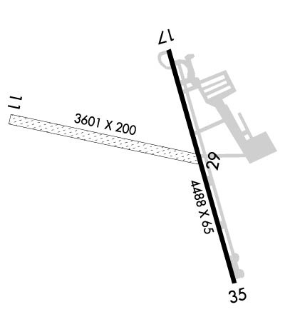
| Rwy | Rwy | |||||||
| 3601x200 | 3601' | 3601x200 | 3601' | |||||
| 4488x65 | 4488' | 4488x65 | 4488' | |||||
| Runway ID | Single Wheel | Double Wheel | Double Tandem Wheel | Dual Double Wheel |
| 11/29 | N/A | N/A | N/A | N/A |
| 17/35 | N/A | N/A | N/A | N/A |
| These numbers are Advisory and are not limits. The Airport Manager should have more accurate Weight Limits | ||||
 Airport Diagram might not be current. | |
| Facility Name: | SUMMIT |
| City Name: | MIDDLETOWN |
| County: | NEW CASTLE |
| State abbrev: | DE |
| State Name: | DELAWARE |
| Ownership: | PRIVATELY OWNED |
| Use: | OPEN TO THE PUBLIC |
| Owner's Name: | GREENWICH AEROGROUP |
| Address: | 4200 SUMMIT BRIDGE ROAD |
| MIDDLETOWN, DE 19709 | |
| Owner's Phone: | 302-834-5400 |
| Manager's Name: | RALPH KUNZ |
| Address: | 4200 SUMMIT BRIDGE ROAD |
| MIDDLETOWN, DE 19709 | |
| Phone: | 302-834-5400 |
| FAA Region: | EASTERN |
| FAA Field Office: | HAR |
| Date | Sunrise | Sunset |
|---|---|---|
| 02/05/25 Wednesday | 7:07 | 17:28 |
| 02/06/25 Thursday | 7:06 | 17:29 |
| 02/07/25 Friday | 7:05 | 17:30 |
| 02/08/25 Saturday | 7:04 | 17:31 |
| 02/09/25 Sunday | 7:03 | 17:32 |
| 02/10/25 Monday | 7:01 | 17:34 |
| 02/11/25 Tuesday | 7:00 | 17:35 |
| 02/12/25 Wednesday | 6:59 | 17:36 |
| 02/13/25 Thursday | 6:58 | 17:37 |
| 02/14/25 Friday | 6:57 | 17:38 |
| 02/15/25 Saturday | 6:55 | 17:39 |
| 02/16/25 Sunday | 6:54 | 17:40 |
| 02/17/25 Monday | 6:53 | 17:42 |
| 02/18/25 Tuesday | 6:52 | 17:43 |
| Airport Attendance Schedule | 7 Days A Week 0700-1900 |
| Airport Status | OPERATIONAL (This Status can change at any time - please check NOTAMS) |
| Airport Lighting Schedule | ACTVT LIRL & REILS RY 11/29 - 123.5. |
| Airport Storage Available | Tie Downs, Hanger |
| Extra Services Available | Avionics, Flight Instruction |
| Wind Indicator | YES - (lighted) |
| Control Tower | NO |
| CTAF Frequency | 122.725 |
| Unicom Frequency | 122.725 |
| Rotating Beacon Color | WG |
| Segmented Circle | YES |
| Landing Fee | NO |
| Airport Inspected | STATE - performed by PRIVATE CONTRACT PERSONNEL |
| Inspection Date | 09/28/2023 |
| Type of Fuel Available | Grade 100LL, JET A (freeze point -40C) |
| Airframe Repair Service | MAJOR |
| Power Plant Repair Service | MAJOR |
| Latitude | N3931.3 |
| Longitude | W07543.4 (ESTIMATED) |
| Arpt Elevation | 69ft (SURVEYED) |
| Magnetic Variation | 10W |
| 5 miles N | of MIDDLETOWN |
| Traffic Pattern Altitude | |
| Sectional Chart | WASHINGTON |
| Operations (Reported) | Yearly | Avg. Daily |
|---|---|---|
| General Aviation Transient | 0 | 0 |
| General Aviation Local | 0 | 0 |
| Air Taxi | 0 | 0 |
| Commerical | 0 | 0 |
| Commuter | 0 | 0 |
| Military | 0 | 0 |
| Aircraft based on Field | |
|---|---|
| General Aviation Singles | 0 |
| General Aviation Multi | 0 |
| Jet Aircraft | 0 |
| General Aviation Helicopters | 0 |
| Military Aircraft | 0 |
| Gliders | 0 |
| Ultralights | 0 |
| FSS on field | NO |
| FSS tie-in | MILLVILLE |
| FSS Phone | 1-800-WX-BRIEF |
| Who issues Notams | MIV |
| Notam D service at airport | YES |
| ARTCC Name | WASHINGTON |
| Airport Certification | |
| Aircraft Rescue & Firefighting Index | None |
| Airport of Entry | No |
| Custom Landing Rights | No |
| Joint Civil/Military | No |
| Military Landing rights | No |
| NATIONAL PLAN OF INTEGRATED AIRPORT SYSTEMS (NPIAS) |
| ASSURANCES PURSUANT TO TITLE VI, CIVIL RIGHTS ACT OF 1964 |
| THIS AIRPORT HAS BEEN SURVEYED BY THE NATIONAL GEODETIC SURVEY. |
| EXTSV MED/HVY HEL TRNG IN PROG ALL HRS ON & INVOF ARPT; HIGH ROTOR DOWNWASH VELOCITIES. WHEN CH47 HELICOPTERS OPERATING, REQUEST ADVISORIES ON UNICOM. |
| FOR CD CTC PHILADELPHIA APCH AT 800-354-9884. |
| RWY 11/29 CLSD FOR NIGHT OPS. |
| RWY 11/2 9 LIRL RY 11/29 OTS INDEFLY. |
Airport Communications & Frequencies:
| |||||||||||||||||
| Runway: 11 | Runway: 29 | ||
| Mag heading: | 108° | Mag heading: | 288° |
| Approach: | Approach: | ||
| Pattern: | Left Traffic | Pattern: | Left Traffic |
| Markings: | Markings: | ||
| Marking Condition: | Marking Condition: | ||
| Arresting Dev: | Arresting Dev: | ||
| Lat & Long: | N3931.3 W07544.0 | Lat. & Long.: | N3931.3 W07543.3 |
| Elev: | N/A | Elev: | N/A |
| TCH: | TCH: | ||
| Visual Glide Path: | Visual Glide Path: | ||
| Displaced Threshold: | No | Displaced Threshold: | No |
| Touchdown Zone: | NO | Touchdown Zone: | NO |
| Touchdown Elev.: | Touchdown Elev.: | ||
| Visual Glide Slope: | Visual Glide Slope: | ||
| RVR Equipment: | RVR Equipment: | ||
| RVV Equipment: | NO | RVV Equipment: | NO |
| Approach Lights: | Approach Lights: | ||
| REIL: | YES; REIL RY 11 & RY 29 OTS INDEFLY. | REIL: | YES |
| Centerline Lights: | NO | Centerline Lights: | NO |
| Touchdown lights: | NO | Touchdown lights: | NO |
| Runway Category: | Runway with a Visual Approach | Runway Category: | Runway with a Visual Approach |
| Declared Distances: | Declared Distances: | ||
| Obstructions: | TREE | Obstructions: | |
| Marked: | NOT Marked/Lighted | Marked: | |
| Clearance slope: | 10:1 | Clearance slope: | 50:1 |
| Obstruction height: | 42 feet AGL | Obstruction height: | |
| Dist. from runway: | 420 feet | Dist. from runway: | |
| Centerline offset: | 70 left of centerline | Centerline offset: | |
| Comments: | Comments: |
| Runway: 17 | Runway: 35 | ||
| Mag heading: | 175° | Mag heading: | 355° |
| Rwy Slope: | .00% Down | Rwy Slope: | .00% Up |
| Approach: | Approach: | ||
| Pattern: | Left Traffic | Pattern: | Left Traffic |
| Markings: | NONPRECISION INSTRUMENT | Markings: | NONPRECISION INSTRUMENT |
| Marking Condition: | GOOD | Marking Condition: | GOOD |
| Arresting Dev: | Arresting Dev: | ||
| Lat & Long: | N3931.6 W07543.3 | Lat. & Long.: | N3930.9 W07543.1 |
| Elev: | 64.9 ft. MSL | Elev: | 64.8 ft. MSL |
| TCH: | 41 ft. AGL | TCH: | 41 ft. AGL |
| Visual Glide Path: | 3.00 degrees | Visual Glide Path: | 3.00 degrees |
| Displaced Threshold: | No | Displaced Threshold: | No |
| Touchdown Zone: | YES | Touchdown Zone: | YES |
| Touchdown Elev.: | 69.9 feet | Touchdown Elev.: | 69.9 feet |
| Visual Glide Slope: | 4-Light PAPI on RIGHT side of Runway | Visual Glide Slope: | 4-Light PAPI on LEFT side of Runway |
| RVR Equipment: | RVR Equipment: | ||
| RVV Equipment: | NO | RVV Equipment: | NO |
| Approach Lights: | Approach Lights: | ||
| REIL: | YES | REIL: | YES |
| Centerline Lights: | NO | Centerline Lights: | NO |
| Touchdown lights: | NO | Touchdown lights: | NO |
| Runway Category: | Runway with a Visual Approach | Runway Category: | Runway with a Non-precision Approach |
| Declared Distances: | Declared Distances: | ||
| Obstructions: | TREES | Obstructions: | |
| Marked: | NOT Marked/Lighted | Marked: | |
| Clearance slope: | 15:1 | Clearance slope: | 50:1 |
| Obstruction height: | 70 feet AGL | Obstruction height: | |
| Dist. from runway: | 1250 feet | Dist. from runway: | |
| Centerline offset: | Centerline offset: | ||
| Comments: | Comments: |
Thanks for using FltPlan.com
all rights reserved © 1999-2025 by Flight Plan LLC