
| SCHOLES INTL AT GALVESTON GALVESTON TX |
| |
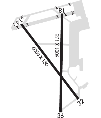
| Lat: N 2915.9 Long: W 09451.6 Elev: 6 Var: -02 Longest Runway: 6001 | ||
| Clr Del: 135.35 AWOS: 119.27 Ground: 118.62 Tower: 120.57 | ||
| ||||||||||||||||||||||||||||||||||||||||||||
| ||||||||||||||||||||||||||||||||||||||||||||
| ||||||||||||||||||||||||||||||||||||||||||||
| Rwy | Rwy | |||||||
| 6000x150 | 6000' | 111.70 - 138° | 6000x150 | 6000' | ||||
| 6001x150 | 6001' | 6001x150 | 6001' | |||||
| Runway ID | Single Wheel | Double Wheel | Double Tandem Wheel | Dual Double Wheel |
| 14/32 | 30,000 | 45,000 | 90,000 | N/A |
| 18/36 | 30,000 | 45,000 | 90,000 | N/A |
| These numbers are Advisory and are not limits. The Airport Manager should have more accurate Weight Limits | ||||
 Airport Diagram might not be current. | |
| Facility Name: | SCHOLES INTL AT GALVESTON |
| City Name: | GALVESTON |
| County: | GALVESTON |
| State abbrev: | TX |
| State Name: | TEXAS |
| Ownership: | PUBLICLY OWNED |
| Use: | OPEN TO THE PUBLIC |
| Owner's Name: | CITY OF GALVESTON |
| Address: | PO BOX 779 |
| GALVESTON, TX 77552 | |
| Owner's Phone: | (409) 797-2590 |
| Manager's Name: | MIKE SHAHAN |
| Address: | 2115 TERMINAL DRIVE |
| GALVESTON, TX 77554 | |
| Phone: | (409) 797-3590 |
| FAA Region: | SOUTHWEST |
| FAA Field Office: | TEX |

| Date | Sunrise | Sunset |
|---|---|---|
| 09/24/21 Friday | 7:09 | 19:14 |
| 09/25/21 Saturday | 7:09 | 19:13 |
| 09/26/21 Sunday | 7:10 | 19:11 |
| 09/27/21 Monday | 7:10 | 19:10 |
| 09/28/21 Tuesday | 7:11 | 19:09 |
| 09/29/21 Wednesday | 7:11 | 19:08 |
| 09/30/21 Thursday | 7:12 | 19:07 |
| 10/01/21 Friday | 7:12 | 19:05 |
| 10/02/21 Saturday | 7:13 | 19:04 |
| 10/03/21 Sunday | 7:14 | 19:03 |
| 10/04/21 Monday | 7:14 | 19:02 |
| 10/05/21 Tuesday | 7:15 | 19:01 |
| 10/06/21 Wednesday | 7:15 | 18:59 |
| 10/07/21 Thursday | 7:16 | 18:58 |
| Airport Attendance Schedule | 7 Days A Week 0600-2000 |
| Airport Status | OPERATIONAL (This Status can change at any time - please check NOTAMS) |
| Airport Lighting Schedule | HIRL RWY 14/32, MIRL RWY 18/36 PRESET ON MED INTST. WHEN ATCT CLSD ACTVT MALSR RWY 14 - CTAF. |
| Airport Storage Available | Tie Downs, Hanger |
| Extra Services Available | Charter, Flight Instruction, Aircraft Rental |
| Wind Indicator | YES - (lighted) |
| Control Tower | YES |
| CTAF Frequency | 120.575 |
| Unicom Frequency | 123.050 |
| Rotating Beacon Color | CLEAR-GREEN (Light Land Airport) |
| Segmented Circle | YES |
| Landing Fee | NO |
| Airport Inspected | STATE - performed by STATE AERONAUTICAL PERSONNEL |
| Inspection Date | 05/04/2017 |
| Type of Fuel Available | Grade 100LL, JET A (freeze point -40C); -10FOR FUEL SVC AFT HRS CALL 409-750-0195. |
| Airframe Repair Service | MINOR |
| Power Plant Repair Service | MAJOR |
| Latitude | N2915.9 |
| Longitude | W09451.6 (ESTIMATED) |
| Arpt Elevation | 5ft (SURVEYED) |
| Magnetic Variation | 02E |
| 3 miles SW | of GALVESTON |
| Traffic Pattern Altitude | |
| Sectional Chart | HOUSTON |
| Operations (Reported) | Yearly | Avg. Daily |
|---|---|---|
| General Aviation Transient | 13879 | 38 |
| General Aviation Local | 8836 | 24 |
| Air Taxi | 5712 | 16 |
| Commerical | 10 | 0 |
| Commuter | 0 | 0 |
| Military | 1619 | 4 |
| Aircraft based on Field | |
|---|---|
| General Aviation Singles | 90 |
| General Aviation Multi | 9 |
| Jet Aircraft | 8 |
| General Aviation Helicopters | 27 |
| Military Aircraft | 0 |
| Gliders | 0 |
| Ultralights | 0 |
| FSS on field | NO |
| FSS tie-in | MONTGOMERY COUNTY |
| FSS Phone | 1-800-WX-BRIEF |
| Who issues Notams | GLS |
| Notam D service at airport | YES |
| ARTCC Name | HOUSTON |
| Airport Certification | |
| Aircraft Rescue & Firefighting Index | None |
| Airport of Entry | No |
| Custom Landing Rights | YES |
| Joint Civil/Military | No |
| Military Landing rights | YES |
| NATIONAL PLAN OF INTEGRATED AIRPORT SYSTEMS (NPIAS) |
| GRANT AGREEMENTS UNDER FAAP/ADAP/AIP |
| SURPLUS PROPERTY AGREEMENT UNDER PUBLIC LAW 289 |
| ASSURANCES PURSUANT TO TITLE VI, CIVIL RIGHTS ACT OF 1964 |
| AGREEMENT UNDER DLAND OR DCLA HAS EXPIRED. |
| FLOCKS OF BIRDS INVOF ARPT BLW 200 FT AGL. |
| 124 FT LGTD CRANE NW SIDE OF ARPT. |
| FOR CD WHEN ATCT IS CLSD CTC HOUSTON APCH AT 281-443-5844 TO CNL IFR AT 281-443-5888. |
| HELS OPRG ON & INVOF ARPT. |
| 178 FT LGTD BLDG 2000 FT NE OF RWY 18 THR. |
| PAEW ADJ RWYS & TWYS. |
| TWO 157 FT MSL LGTD TOWERS BTN RWYS 32 & 36. |
| RWY 14/3 2 FIRST 1300 FT NW END IS CONC. |
Airport Communications & Frequencies:
| ||||||||||||||||||||
| Runway: 14 | Runway: 32 | ||
| Mag heading: | 138° | Mag heading: | 318° |
| Rwy Slope: | -.01% Down | Rwy Slope: | .01% Up |
| Approach: | ILS | Approach: | |
| Pattern: | Left Traffic | Pattern: | Left Traffic |
| Markings: | PRECISION INSTRUMENT | Markings: | PRECISION INSTRUMENT |
| Marking Condition: | GOOD | Marking Condition: | GOOD |
| Arresting Dev: | Arresting Dev: | ||
| Lat & Long: | N2916.3 W09452.1 | Lat. & Long.: | N2915.5 W09451.3 |
| Elev: | 5.3 ft. MSL | Elev: | 4.6 ft. MSL |
| TCH: | 52 ft. AGL | TCH: | 46 ft. AGL |
| Visual Glide Path: | 3.00 degrees | Visual Glide Path: | 3.00 degrees |
| Displaced Threshold: | No | Displaced Threshold: | No |
| Touchdown Zone: | YES | Touchdown Zone: | YES |
| Touchdown Elev.: | 5.3 feet | Touchdown Elev.: | 5.0 feet |
| Visual Glide Slope: | 4-Light PAPI on LEFT side of Runway | Visual Glide Slope: | 4-Light PAPI on LEFT side of Runway |
| RVR Equipment: | RVR Equipment: | ||
| RVV Equipment: | NO | RVV Equipment: | NO |
| Approach Lights: | MALSR - 1,400 foot medium intensity approach lighting system with runway alignment indicator lights | Approach Lights: | |
| REIL: | NO | REIL: | YES |
| Centerline Lights: | NO | Centerline Lights: | NO |
| Touchdown lights: | NO | Touchdown lights: | NO |
| Runway Category: | Precision Instrument Runway | Runway Category: | Runway with a Non-precision Approach having visibility minimums greater than 3/4 mile |
| Declared Distances: | TORA:6000' TODA:6000' ASDA:6000' LDA:6000' | Declared Distances: | TORA:6000' TODA:6000' ASDA:6000' LDA:6000' |
| Obstructions: | Obstructions: | BLDG | |
| Marked: | Marked: | NOT Marked/Lighted | |
| Clearance slope: | 50:1 | Clearance slope: | 28:1 |
| Obstruction height: | Obstruction height: | 80 feet AGL | |
| Dist. from runway: | Dist. from runway: | 2492 feet | |
| Centerline offset: | Centerline offset: | 130 feet left of centerline | |
| Comments: | Comments: |
| Runway: 18 | Runway: 36 | ||
| Mag heading: | 179° | Mag heading: | 359° |
| Rwy Slope: | -.02% Down | Rwy Slope: | .02% Up |
| Approach: | Approach: | ||
| Pattern: | Left Traffic | Pattern: | Left Traffic |
| Markings: | NONPRECISION INSTRUMENT | Markings: | NONPRECISION INSTRUMENT |
| Marking Condition: | GOOD | Marking Condition: | GOOD |
| Arresting Dev: | Arresting Dev: | ||
| Lat & Long: | N2916.4 W09451.5 | Lat. & Long.: | N2915.4 W09451.6 |
| Elev: | 5.6 ft. MSL | Elev: | 4.6 ft. MSL |
| TCH: | 44 ft. AGL | TCH: | 45 ft. AGL |
| Visual Glide Path: | 3.00 degrees | Visual Glide Path: | 3.00 degrees |
| Displaced Threshold: | No | Displaced Threshold: | No |
| Touchdown Zone: | YES | Touchdown Zone: | YES |
| Touchdown Elev.: | 5.6 feet | Touchdown Elev.: | 4.8 feet |
| Visual Glide Slope: | 4-Light PAPI on LEFT side of Runway | Visual Glide Slope: | 4-Light PAPI on LEFT side of Runway |
| RVR Equipment: | RVR Equipment: | ||
| RVV Equipment: | NO | RVV Equipment: | NO |
| Approach Lights: | Approach Lights: | ||
| REIL: | YES | REIL: | YES |
| Centerline Lights: | NO | Centerline Lights: | NO |
| Touchdown lights: | NO | Touchdown lights: | NO |
| Runway Category: | Runway with a Non-precision Approach having visibility minimums greater than 3/4 mile | Runway Category: | Runway with a Non-precision Approach having visibility minimums greater than 3/4 mile |
| Declared Distances: | TORA:6001' TODA:6001' ASDA:6001' LDA:6001' | Declared Distances: | TORA:6001' TODA:6001' ASDA:6001' LDA:6001' |
| Obstructions: | Obstructions: | BLDG | |
| Marked: | Marked: | NOT Marked/Lighted | |
| Clearance slope: | 50:1 | Clearance slope: | 23:1 |
| Obstruction height: | Obstruction height: | 120 feet AGL | |
| Dist. from runway: | Dist. from runway: | 2970 feet | |
| Centerline offset: | Centerline offset: | 240 feet right of centerline | |
| Comments: | Comments: |
Thanks for using FltPlan.com
all rights reserved © 1999-2021 by Flight Plan LLC