
| GRND RAPIDS/ITASCA CO-NEWSTROM GRAND RAPIDS MN |
| |
| Lat: N 4712.6 Long: W 09330.6 Elev: 1356 Var: -02 Longest Runway: 5756 | ||
| AWOS: 118.42 CTAF: 122.8 | ||
| |||||||||||||||||||||||||||||||||||||||||||||||||||||||||||||
| |||||||||||||||||||||||||||||||||||||||||||||||||||||||||||||
| |||||||||||||||||||||||||||||||||||||||||||||||||||||||||||||
| Rwy | Rwy | |||||||
| 3000x60 | 3000' | 3000x60 | 3000' | |||||
| 5756x100 | 5756' | 5756x100 | 5756' | 110.10 - 343° | ||||
| Runway ID | Single Wheel | Double Wheel | Double Tandem Wheel | Dual Double Wheel |
| 05/23 | 12,500 | N/A | N/A | N/A |
| 16/34 | 23,000 | 38,000 | 78,000 | N/A |
| These numbers are Advisory and are not limits. The Airport Manager should have more accurate Weight Limits | ||||
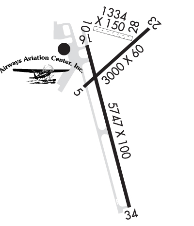 Airport Diagram might not be current. | |
| Facility Name: | GRAND RAPIDS/ITASCA COUNTY-GORDON NEWSTROM FLD |
| City Name: | GRAND RAPIDS |
| County: | ITASCA |
| State abbrev: | MN |
| State Name: | MINNESOTA |
| Ownership: | PUBLICLY OWNED |
| Use: | OPEN TO THE PUBLIC |
| Owner's Name: | GRAND RAPIDS / ITASCA CO |
| Address: | 420 N POKEGAMA AVE |
| GRAND RAPIDS, MN 55744 | |
| Owner's Phone: | 218-326-0893 |
| Manager's Name: | MATT WEGWERTH; MWEGWERTH@CI.GRAND-RAPIDS.MN.US. |
| Address: | 420 N POKEGAMA AVE |
| GRAND RAPIDS, MN 55744 | |
| Phone: | 218-326-7625 |
| FAA Region: | GREAT LAKES |
| FAA Field Office: | DMA |
| Date | Sunrise | Sunset |
|---|---|---|
| 04/26/25 Saturday | 6:07 | 20:18 |
| 04/27/25 Sunday | 6:05 | 20:19 |
| 04/28/25 Monday | 6:03 | 20:21 |
| 04/29/25 Tuesday | 6:01 | 20:22 |
| 04/30/25 Wednesday | 6:00 | 20:23 |
| 05/01/25 Thursday | 5:58 | 20:25 |
| 05/02/25 Friday | 5:57 | 20:26 |
| 05/03/25 Saturday | 5:55 | 20:28 |
| 05/04/25 Sunday | 5:54 | 20:29 |
| 05/05/25 Monday | 5:52 | 20:30 |
| 05/06/25 Tuesday | 5:50 | 20:32 |
| 05/07/25 Wednesday | 5:49 | 20:33 |
| 05/08/25 Thursday | 5:48 | 20:34 |
| 05/09/25 Friday | 5:46 | 20:36 |
| Airport Attendance Schedule | APR-OCT 7 Days A Week 0700-2100, NOV-MAR 7 Days A Week 0700-2000 |
| Airport Status | OPERATIONAL (This Status can change at any time - please check NOTAMS) |
| Airport Lighting Schedule | ACTVT MALSR RWY 34; REIL RWY 05, 16, 23; PAPI RWY 05, 16, 23, 34; MIRL RWY 05/23; HIRL RWY 16/34 - CTAF. |
| Airport Storage Available | Tie Downs, Hanger |
| Extra Services Available | Air Freight, Beaching Gear, Charter, Flight Instruction, Aircraft Rental, Aircraft Sales |
| Wind Indicator | YES - (lighted) |
| Control Tower | NO |
| CTAF Frequency | 122.800 |
| Unicom Frequency | 122.800 |
| Rotating Beacon Color | WG |
| Segmented Circle | YES |
| Landing Fee | NO |
| Airport Inspected | FEDERAL - performed by STATE AERONAUTICAL PERSONNEL |
| Inspection Date | 06/23/2022 |
| Type of Fuel Available | Grade 100LL, JET A (freeze point -40C) |
| Airframe Repair Service | MAJOR |
| Power Plant Repair Service | MAJOR |
| Latitude | N4712.6 |
| Longitude | W09330.6 (ESTIMATED) |
| Arpt Elevation | 1355ft (SURVEYED) |
| Magnetic Variation | 02E |
| 2 miles SE | of GRAND RAPIDS |
| Traffic Pattern Altitude | |
| Sectional Chart | TWIN CITIES |
| Operations (Reported) | Yearly | Avg. Daily |
|---|---|---|
| General Aviation Transient | 0 | 0 |
| General Aviation Local | 0 | 0 |
| Air Taxi | 0 | 0 |
| Commerical | 0 | 0 |
| Commuter | 0 | 0 |
| Military | 0 | 0 |
| Aircraft based on Field | |
|---|---|
| General Aviation Singles | 0 |
| General Aviation Multi | 0 |
| Jet Aircraft | 0 |
| General Aviation Helicopters | 0 |
| Military Aircraft | 0 |
| Gliders | 0 |
| Ultralights | 0 |
| FSS on field | NO |
| FSS tie-in | PRINCETON |
| FSS Phone | 1-800-WX-BRIEF |
| Who issues Notams | GPZ |
| Notam D service at airport | YES |
| ARTCC Name | MINNEAPOLIS |
| Airport Certification | |
| Aircraft Rescue & Firefighting Index | None |
| Airport of Entry | No |
| Custom Landing Rights | No |
| Joint Civil/Military | No |
| Military Landing rights | YES |
| NATIONAL PLAN OF INTEGRATED AIRPORT SYSTEMS (NPIAS) |
| GRANT AGREEMENTS UNDER FAAP/ADAP/AIP |
| ASSURANCES PURSUANT TO TITLE VI, CIVIL RIGHTS ACT OF 1964 |
| LILY LAKE SPB OPS N OF ARPT; PPR RQR CTC - (218) 326-1226. |
| DEER AND BIRDS ON & INVOF ARPT. |
| FOR CD IF UNA TO CTC ON FSS FREQ, CTC MINNEAPOLIS ARTCC AT 651-463-5588. |
| RWY 34 CALM WIND RWY. |
| RWY 16/3 4 228 FT PAVED AREA AT N END. |
Airport Communications & Frequencies:
| |||||||||
| Runway: 05 | Runway: 23 | ||
| Mag heading: | 45° | Mag heading: | 225° |
| Rwy Slope: | -.27% Down | Rwy Slope: | .27% Up |
| Approach: | Approach: | ||
| Pattern: | Left Traffic | Pattern: | Left Traffic |
| Markings: | BASIC | Markings: | BASIC |
| Marking Condition: | GOOD | Marking Condition: | GOOD |
| Arresting Dev: | Arresting Dev: | ||
| Lat & Long: | N4712.6 W09330.8 | Lat. & Long.: | N4713.0 W09330.3 |
| Elev: | 1302.3 ft. MSL | Elev: | 1294.3 ft. MSL |
| TCH: | 50 ft. AGL | TCH: | 41 ft. AGL |
| Visual Glide Path: | 3.50 degrees | Visual Glide Path: | 3.00 degrees |
| Displaced Threshold: | No | Displaced Threshold: | No |
| Touchdown Zone: | YES | Touchdown Zone: | YES |
| Touchdown Elev.: | 1302.3 feet | Touchdown Elev.: | 1302.3 feet |
| Visual Glide Slope: | 4-Light PAPI on LEFT side of Runway; UNUSBL BYD 6 DEGS LEFT AND RIGHT OF CNTRLN. | Visual Glide Slope: | 4-Light PAPI on LEFT side of Runway |
| RVR Equipment: | RVR Equipment: | ||
| RVV Equipment: | NO | RVV Equipment: | NO |
| Approach Lights: | Approach Lights: | ||
| REIL: | YES | REIL: | YES |
| Centerline Lights: | NO | Centerline Lights: | NO |
| Touchdown lights: | NO | Touchdown lights: | NO |
| Runway Category: | Runway with a Visual Approach | Runway Category: | Runway with a Visual Approach |
| Declared Distances: | Declared Distances: |
| Runway: 16 | Runway: 34 | ||
| Mag heading: | 164° | Mag heading: | 344° |
| Rwy Slope: | 1.00% Up | Rwy Slope: | -1.00% Down |
| Approach: | Approach: | ILS | |
| Pattern: | Left Traffic | Pattern: | Left Traffic |
| Markings: | PRECISION INSTRUMENT | Markings: | PRECISION INSTRUMENT |
| Marking Condition: | GOOD | Marking Condition: | GOOD |
| Arresting Dev: | Arresting Dev: | ||
| Lat & Long: | N4712.9 W09330.8 | Lat. & Long.: | N4712.0 W09330.4 |
| Elev: | 1298.1 ft. MSL | Elev: | 1355.7 ft. MSL |
| TCH: | 50 ft. AGL | TCH: | 53 ft. AGL |
| Visual Glide Path: | 3.00 degrees | Visual Glide Path: | 3.00 degrees |
| Displaced Threshold: | No | Displaced Threshold: | No |
| Touchdown Zone: | YES | Touchdown Zone: | YES |
| Touchdown Elev.: | 1326.5 feet | Touchdown Elev.: | 1355.7 feet |
| Visual Glide Slope: | 4-Light PAPI on RIGHT side of Runway | Visual Glide Slope: | 4-Light PAPI on LEFT side of Runway |
| RVR Equipment: | RVR Equipment: | ||
| RVV Equipment: | NO | RVV Equipment: | NO |
| Approach Lights: | Approach Lights: | MALSR - 1,400 foot medium intensity approach lighting system with runway alignment indicator lights | |
| REIL: | YES | REIL: | NO |
| Centerline Lights: | NO | Centerline Lights: | NO |
| Touchdown lights: | NO | Touchdown lights: | NO |
| Runway Category: | Runway with a Non-precision Approach having visibility minimums greater than 3/4 mile | Runway Category: | Precision Instrument Runway |
| Declared Distances: | Declared Distances: | ||
| Obstructions: | Obstructions: | ROAD | |
| Marked: | Marked: | NOT Marked/Lighted | |
| Clearance slope: | 34:1 | Clearance slope: | 1:1 |
| Obstruction height: | Obstruction height: | 9 feet AGL | |
| Dist. from runway: | Dist. from runway: | 212 feet | |
| Centerline offset: | Centerline offset: | 490 feet right of centerline | |
| Comments: | Comments: |
Thanks for using FltPlan.com
all rights reserved © 1999-2025 by Flight Plan LLC

