
| GREELEY-WELD COUNTY GREELEY CO |
| |
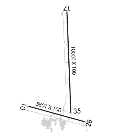
| Lat: N 4026.2 Long: W 10438.0 Elev: 4697 Var: -08 Longest Runway: 10000 | ||
| Clr Del: 126.65 AWOS: 135.17 CTAF: 122.8 | ||
| ||||||||||||||||||||||||||||||||||||||||||||
| ||||||||||||||||||||||||||||||||||||||||||||
| ||||||||||||||||||||||||||||||||||||||||||||
| Rwy | Rwy | |||||||
| 5801x100 | 5801' | 5801x100 | 5801' | |||||
| 10000x100 | 10000' | 10000x100 | 8900' | 110.30 - 349° | ||||
| Runway ID | Single Wheel | Double Wheel | Double Tandem Wheel | Dual Double Wheel |
| 10/28 | 18,000 | 30,000 | N/A | N/A |
| 17/35 | 30,000 | 45,000 | N/A | N/A |
| H1 | N/A | N/A | N/A | N/A |
| H2 | N/A | N/A | N/A | N/A |
| These numbers are Advisory and are not limits. The Airport Manager should have more accurate Weight Limits | ||||
 Airport Diagram might not be current. | |
| Facility Name: | GREELEY-WELD COUNTY |
| City Name: | GREELEY |
| County: | WELD |
| State abbrev: | CO |
| State Name: | COLORADO |
| Ownership: | PUBLICLY OWNED |
| Use: | OPEN TO THE PUBLIC |
| Owner's Name: | GREELEY-WELD CO ARPT AUTH |
| Address: | PO BOX 727 |
| GREELEY, CO 80632 | |
| Owner's Phone: | 970-336-3000 |
| Manager's Name: | COOPER ANDERSON |
| Address: | PO BOX 727 |
| GREELEY, CO 80632 | |
| Phone: | (970) 336-3001 |
| FAA Region: | NORTHWEST MOUNTAIN |
| FAA Field Office: | DEN |
| Date | Sunrise | Sunset |
|---|---|---|
| 09/24/21 Friday | 6:48 | 18:53 |
| 09/25/21 Saturday | 6:49 | 18:51 |
| 09/26/21 Sunday | 6:50 | 18:49 |
| 09/27/21 Monday | 6:51 | 18:48 |
| 09/28/21 Tuesday | 6:52 | 18:46 |
| 09/29/21 Wednesday | 6:53 | 18:44 |
| 09/30/21 Thursday | 6:54 | 18:43 |
| 10/01/21 Friday | 6:55 | 18:41 |
| 10/02/21 Saturday | 6:56 | 18:39 |
| 10/03/21 Sunday | 6:57 | 18:38 |
| 10/04/21 Monday | 6:58 | 18:36 |
| 10/05/21 Tuesday | 6:59 | 18:34 |
| 10/06/21 Wednesday | 7:00 | 18:33 |
| 10/07/21 Thursday | 7:01 | 18:31 |
| Airport Attendance Schedule | 7 Days A Week 0600-1900; PREARRANGE AFTER HOURS AIRPORT ACCESS WITH FBO'S. CALL 970-336-4866 OR 970-351-8957. |
| Airport Status | OPERATIONAL (This Status can change at any time - please check NOTAMS) |
| Airport Lighting Schedule | ACTVT MIRL RYS 10/28 & 17/35, & REIL RYS 10, 28, 17, & 35 - CTAF. PAPI RYS 10, 17, 35, & VASI RY 28 OPR 24 HRS. |
| Airport Storage Available | Tie Downs, Hanger |
| Extra Services Available | Crop Dusting, Air Ambulance, Charter, Flight Instruction, Aircraft Rental |
| Wind Indicator | YES - (lighted) |
| Control Tower | NO |
| CTAF Frequency | 122.800 |
| Unicom Frequency | 122.800 |
| Rotating Beacon Color | CLEAR-GREEN (Light Land Airport) |
| Segmented Circle | YES |
| Landing Fee | NO |
| Airport Inspected | STATE - performed by STATE AERONAUTICAL PERSONNEL |
| Inspection Date | 06/13/2019 |
| Type of Fuel Available | Grade 100LL, JET A (freeze point -40C) |
| Airframe Repair Service | MAJOR |
| Power Plant Repair Service | MAJOR |
| Latitude | N4026.2 |
| Longitude | W10438.0 (ESTIMATED) |
| Arpt Elevation | 4696ft (SURVEYED) |
| Magnetic Variation | 08E |
| 3 miles E | of GREELEY |
| Traffic Pattern Altitude | 800 |
| Sectional Chart | CHEYENNE |
| Operations (Reported) | Yearly | Avg. Daily |
|---|---|---|
| General Aviation Transient | 44064 | 121 |
| General Aviation Local | 66096 | 181 |
| Air Taxi | 0 | 0 |
| Commerical | 0 | 0 |
| Commuter | 0 | 0 |
| Military | 500 | 1 |
| Aircraft based on Field | |
|---|---|
| General Aviation Singles | 127 |
| General Aviation Multi | 18 |
| Jet Aircraft | 6 |
| General Aviation Helicopters | 3 |
| Military Aircraft | 0 |
| Gliders | 0 |
| Ultralights | 0 |
| FSS on field | NO |
| FSS tie-in | DENVER |
| FSS Phone | 1-800-WX-BRIEF |
| Who issues Notams | GXY |
| Notam D service at airport | YES |
| ARTCC Name | DENVER |
| Airport Certification | |
| Aircraft Rescue & Firefighting Index | None |
| Airport of Entry | No |
| Custom Landing Rights | No |
| Joint Civil/Military | No |
| Military Landing rights | YES |
| NATIONAL PLAN OF INTEGRATED AIRPORT SYSTEMS (NPIAS) |
| GRANT AGREEMENTS UNDER FAAP/ADAP/AIP |
| ASSURANCES PURSUANT TO TITLE VI, CIVIL RIGHTS ACT OF 1964 |
| THIS AIRPORT HAS BEEN SURVEYED BY THE NATIONAL GEODETIC SURVEY. |
| RY 17/35 PREFERRED USE WHEN CROSS WIND COMPONENT EXCEEDS 12 KT ON RY 10/28. |
| RWY 35 PREFERRED USE WHEN WIND LESS THAN 5 KNOTS. RY 35 PREFERRED FOR TGL. |
| WILDLIFE AND BRIDS ON & INVOF APRT. |
| OIL DRILLING RIGS UP TO 120 FT AGL ON AND INVICINTY OF AIRPORT. |
| BE ALERT; INTENSIVE USAF STUDENT TRAINING IN VICINITY OF COLORADO SPRINGS & PUEBLO COLORADO. |
| ACFT DEPG RWY28 AVOID SB TURN PRIOR TO XNG RWY10 THLD. |
Airport Communications & Frequencies:
| |||||||||||||||||||
| Runway: 10 | Runway: 28 | ||
| Mag heading: | 97° | Mag heading: | 277° |
| Rwy Slope: | -.28% Down | Rwy Slope: | .28% Up |
| Approach: | Approach: | ||
| Pattern: | Left Traffic | Pattern: | Right Traffic |
| Markings: | PRECISION INSTRUMENT | Markings: | PRECISION INSTRUMENT |
| Marking Condition: | GOOD | Marking Condition: | GOOD |
| Arresting Dev: | Arresting Dev: | ||
| Lat & Long: | N4025.8 W10438.8 | Lat. & Long.: | N4025.6 W10437.6 |
| Elev: | 4661.2 ft. MSL | Elev: | 4644.8 ft. MSL |
| TCH: | 43 ft. AGL | TCH: | 27 ft. AGL |
| Visual Glide Path: | 3.00 degrees | Visual Glide Path: | 3.00 degrees |
| Displaced Threshold: | No | Displaced Threshold: | No |
| Touchdown Zone: | YES | Touchdown Zone: | YES |
| Touchdown Elev.: | 4661.2 feet | Touchdown Elev.: | 4649.8 feet |
| Visual Glide Slope: | 2-Light PAPI on LEFT side of Runway | Visual Glide Slope: | 4-BOX VASI ON LEFT SIDE OF RUNWAY |
| RVR Equipment: | RVR Equipment: | ||
| RVV Equipment: | NO | RVV Equipment: | NO |
| Approach Lights: | Approach Lights: | ||
| REIL: | YES | REIL: | YES |
| Centerline Lights: | NO | Centerline Lights: | NO |
| Touchdown lights: | NO | Touchdown lights: | NO |
| Runway Category: | Runway with a Non-precision Approach having visibility minimums greater than 3/4 mile | Runway Category: | Runway with a Non-precision Approach having visibility minimums greater than 3/4 mile |
| Declared Distances: | Declared Distances: | ||
| Obstructions: | Obstructions: | POLE | |
| Marked: | Marked: | NOT Marked/Lighted | |
| Clearance slope: | 34:1 | Clearance slope: | 49:1 |
| Obstruction height: | Obstruction height: | 26 feet AGL | |
| Dist. from runway: | Dist. from runway: | 1488 feet | |
| Centerline offset: | Centerline offset: | 66 feet left of centerline | |
| Comments: | +10 FT DIRT ACCESS ROAD AT THLD & PARALLEL TO EXTDD CNTRLN; +9 FT CROPS 140 FT FM THLD 90 FT L & R OF CNTRLN. | Comments: |
| Runway: 17 | Runway: 35 | ||
| Mag heading: | 169° | Mag heading: | 349° |
| Rwy Slope: | -.48% Down | Rwy Slope: | .48% Up |
| Approach: | Approach: | ILS/DME | |
| Pattern: | Left Traffic | Pattern: | Left Traffic |
| Markings: | PRECISION INSTRUMENT | Markings: | PRECISION INSTRUMENT |
| Marking Condition: | GOOD | Marking Condition: | GOOD |
| Arresting Dev: | Arresting Dev: | ||
| Lat & Long: | N4027.4 W10437.9 | Lat. & Long.: | N4025.7 W10437.9 |
| Elev: | 4696.8 ft. MSL | Elev: | 4648.5 ft. MSL |
| TCH: | 46 ft. AGL | TCH: | 51 ft. AGL |
| Visual Glide Path: | 3.00 degrees | Visual Glide Path: | 3.00 degrees |
| Displaced Threshold: | No | Displaced Threshold: | 1100 feet |
| Touchdown Zone: | YES | Touchdown Zone: | YES |
| Touchdown Elev.: | 4696.8 feet | Touchdown Elev.: | 4664.8 feet |
| Visual Glide Slope: | 2-Light PAPI on LEFT side of Runway | Visual Glide Slope: | 2-Light PAPI on LEFT side of Runway |
| RVR Equipment: | RVR Equipment: | ||
| RVV Equipment: | NO | RVV Equipment: | NO |
| Approach Lights: | Approach Lights: | ||
| REIL: | YES | REIL: | YES |
| Centerline Lights: | NO | Centerline Lights: | NO |
| Touchdown lights: | NO | Touchdown lights: | NO |
| Runway Category: | Runway with a Visual Approach | Runway Category: | Precision Instrument Runway |
| Declared Distances: | Declared Distances: | ||
| Obstructions: | TREE | Obstructions: | |
| Marked: | NOT Marked/Lighted | Marked: | |
| Clearance slope: | 47:1 | Clearance slope: | 50:1 |
| Obstruction height: | 56 feet AGL | Obstruction height: | |
| Dist. from runway: | 2834 feet | Dist. from runway: | |
| Centerline offset: | 514 right of centerline | Centerline offset: | |
| Comments: | Comments: |
Thanks for using FltPlan.com
all rights reserved © 1999-2021 by Flight Plan LLC
