
| HERINGTON RGNL HERINGTON KS |
| |
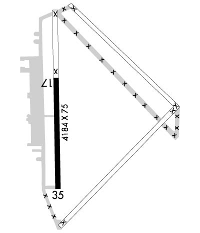
| Lat: N 3841.7 Long: W 09648.5 Elev: 1481 Var: -06 Longest Runway: 4184 | ||
| CTAF: 122.9 | ||
| ||||||||||||||||||||||||||||||||||||||||||||
| ||||||||||||||||||||||||||||||||||||||||||||
| Rwy | Rwy | |||||||
| 4184x75 | 4184' | 4184x75 | 4184' | |||||
| Runway ID | Single Wheel | Double Wheel | Double Tandem Wheel | Dual Double Wheel |
| 17/35 | 38,000 | 52,500 | N/A | N/A |
| These numbers are Advisory and are not limits. The Airport Manager should have more accurate Weight Limits | ||||
 Airport Diagram might not be current. | |
| Facility Name: | HERINGTON RGNL |
| City Name: | HERINGTON |
| County: | MORRIS |
| State abbrev: | KS |
| State Name: | KANSAS |
| Ownership: | PUBLICLY OWNED |
| Use: | OPEN TO THE PUBLIC |
| Owner's Name: | CITY OF HERINGTON |
| Address: | P O BOX 31 |
| HERINGTON, KS 67449 | |
| Owner's Phone: | 785-258-2271 |
| Manager's Name: | MERLIN OSWALD |
| Address: | 3134 US HWY 56 |
| HERINGTON, KS 67449 | |
| Phone: | 785-258-2877; AMGR NIGHTTIME PHONE 785-258-2560. |
| FAA Region: | CENTRAL |
| FAA Field Office: | NONE |
| Date | Sunrise | Sunset |
|---|---|---|
| 02/06/25 Thursday | 7:29 | 17:55 |
| 02/07/25 Friday | 7:28 | 17:56 |
| 02/08/25 Saturday | 7:27 | 17:57 |
| 02/09/25 Sunday | 7:25 | 17:58 |
| 02/10/25 Monday | 7:24 | 17:59 |
| 02/11/25 Tuesday | 7:23 | 18:00 |
| 02/12/25 Wednesday | 7:22 | 18:02 |
| 02/13/25 Thursday | 7:21 | 18:03 |
| 02/14/25 Friday | 7:20 | 18:04 |
| 02/15/25 Saturday | 7:19 | 18:05 |
| 02/16/25 Sunday | 7:17 | 18:06 |
| 02/17/25 Monday | 7:16 | 18:07 |
| 02/18/25 Tuesday | 7:15 | 18:08 |
| 02/19/25 Wednesday | 7:14 | 18:09 |
| Airport Attendance Schedule | UNATTENDED; FOR TRANSPORTATION CALL 785-258-2877 DAYS ONLY OR AIRPORT MGMNT CELL PH. 785-258-0174. NIGHTTIME PH. 785-258-2560. |
| Airport Status | OPERATIONAL (This Status can change at any time - please check NOTAMS) |
| Airport Lighting Schedule | ACTIVATE MIRL, REIL AND PAPI RWY 17/35 CTAF. |
| Airport Storage Available | Tie Downs, Hanger |
| Extra Services Available | Crop Dusting |
| Wind Indicator | YES - (lighted) |
| Control Tower | NO |
| CTAF Frequency | 122.900 |
| Unicom Frequency | |
| Rotating Beacon Color | WG |
| Segmented Circle | NO |
| Landing Fee | NO |
| Airport Inspected | STATE - performed by STATE AERONAUTICAL PERSONNEL |
| Inspection Date | 10/24/2022 |
| Type of Fuel Available | Grade 100LL; -10FUEL AVBL 24 HRS BY CREDIT CARD. |
| Airframe Repair Service | NONE |
| Power Plant Repair Service | NONE |
| Latitude | N3841.7 |
| Longitude | W09648.5 (ESTIMATED) |
| Arpt Elevation | 1480ft (SURVEYED) |
| Magnetic Variation | 06E |
| 7 miles NE | of HERINGTON |
| Traffic Pattern Altitude | |
| Sectional Chart | KANSAS CITY |
| Operations (Reported) | Yearly | Avg. Daily |
|---|---|---|
| General Aviation Transient | 0 | 0 |
| General Aviation Local | 0 | 0 |
| Air Taxi | 0 | 0 |
| Commerical | 0 | 0 |
| Commuter | 0 | 0 |
| Military | 0 | 0 |
| Aircraft based on Field | |
|---|---|
| General Aviation Singles | 0 |
| General Aviation Multi | 0 |
| Jet Aircraft | 0 |
| General Aviation Helicopters | 0 |
| Military Aircraft | 0 |
| Gliders | 0 |
| Ultralights | 0 |
| FSS on field | NO |
| FSS tie-in | WICHITA |
| FSS Phone | 1-800-WX-BRIEF |
| Who issues Notams | ICT |
| Notam D service at airport | YES |
| ARTCC Name | KANSAS CITY |
| Airport Certification | |
| Aircraft Rescue & Firefighting Index | None |
| Airport of Entry | No |
| Custom Landing Rights | No |
| Joint Civil/Military | No |
| Military Landing rights | YES |
| NATIONAL PLAN OF INTEGRATED AIRPORT SYSTEMS (NPIAS) |
| SURPLUS PROPERTY AGREEMENT UNDER PUBLIC LAW 289 |
| ASSURANCES PURSUANT TO TITLE VI, CIVIL RIGHTS ACT OF 1964 |
| PILOTS LOUNGE PHONE NUMBER 785-258-3822. |
| PUBLIC PHONE AVBL 24 HRS IN PILOTS LOUNGE. |
| RDO-CTLD MODEL ACFT ACTIVITY ON ARPT WKENDS & HOLS. |
| FOR CD CTC KANSAS CITY ARTCC AT 913-254-8508. |
Airport Communications & Frequencies:
| |||||||
| Runway: 17 | Runway: 35 | ||
| Mag heading: | 174° | Mag heading: | 354° |
| Rwy Slope: | -.02% Down | Rwy Slope: | .02% Up |
| Approach: | Approach: | ||
| Pattern: | Left Traffic | Pattern: | Left Traffic |
| Markings: | NONPRECISION INSTRUMENT | Markings: | NONPRECISION INSTRUMENT |
| Marking Condition: | GOOD | Marking Condition: | GOOD |
| Arresting Dev: | Arresting Dev: | ||
| Lat & Long: | N3842.0 W09648.5 | Lat. & Long.: | N3841.3 W09648.5 |
| Elev: | 1478.1 ft. MSL | Elev: | 1477.1 ft. MSL |
| TCH: | 40 ft. AGL | TCH: | 40 ft. AGL |
| Visual Glide Path: | 3.00 degrees | Visual Glide Path: | 3.00 degrees |
| Displaced Threshold: | No | Displaced Threshold: | No |
| Touchdown Zone: | YES | Touchdown Zone: | YES |
| Touchdown Elev.: | 1480.6 feet | Touchdown Elev.: | 1480.6 feet |
| Visual Glide Slope: | 4-Light PAPI on LEFT side of Runway | Visual Glide Slope: | 4-Light PAPI on LEFT side of Runway |
| RVR Equipment: | RVR Equipment: | ||
| RVV Equipment: | NO | RVV Equipment: | NO |
| Approach Lights: | Approach Lights: | ||
| REIL: | YES | REIL: | YES |
| Centerline Lights: | NO | Centerline Lights: | NO |
| Touchdown lights: | NO | Touchdown lights: | NO |
| Runway Category: | Runway with a Non-precision Approach having visibility minimums greater than 3/4 mile | Runway Category: | Runway with a Non-precision Approach having visibility minimums greater than 3/4 mile |
| Declared Distances: | Declared Distances: |
Thanks for using FltPlan.com
all rights reserved © 1999-2025 by Flight Plan LLC
