
| CLERMONT COUNTY BATAVIA OH |
| |
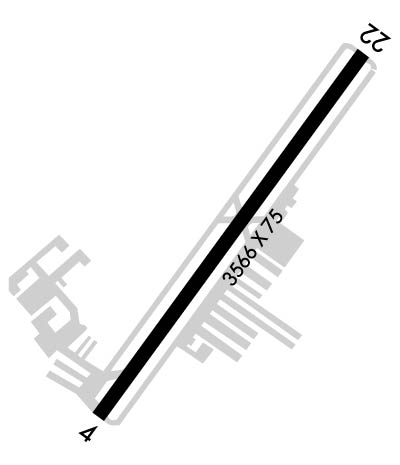
| Lat: N 3904.7 Long: W 08412.6 Elev: 843 Var: +04 Longest Runway: 3566 | ||
| Clr Del: 124.9 AWOS: 127.27 CTAF: 122.97 | ||
| ||||||||||||||||||||||||||||||||||||||||||||
| ||||||||||||||||||||||||||||||||||||||||||||
| ||||||||||||||||||||||||||||||||||||||||||||
| Rwy | Rwy | |||||||
| 3566x75 | 3170' | 3566x75 | 3566' | |||||
| Runway ID | Single Wheel | Double Wheel | Double Tandem Wheel | Dual Double Wheel |
| 04/22 | N/A | N/A | N/A | N/A |
| These numbers are Advisory and are not limits. The Airport Manager should have more accurate Weight Limits | ||||
 Airport Diagram might not be current. | |
| Facility Name: | CLERMONT COUNTY |
| City Name: | BATAVIA |
| County: | CLERMONT |
| State abbrev: | OH |
| State Name: | OHIO |
| Ownership: | PUBLICLY OWNED |
| Use: | OPEN TO THE PUBLIC |
| Owner's Name: | CLERMONT CO COMSNRS |
| Address: | 101 E MAIN ST |
| BATAVIA, OH 45103 | |
| Owner's Phone: | 513-735-9500 |
| Manager's Name: | CHUCK GALLAGHER |
| Address: | 2001 SPORTYS DR |
| BATAVIA, OH 45103-9719 | |
| Phone: | 513-735-9100; EXTN 227. |
| FAA Region: | GREAT LAKES |
| FAA Field Office: | DET |
| Date | Sunrise | Sunset |
|---|---|---|
| 09/24/21 Friday | 7:26 | 19:31 |
| 09/25/21 Saturday | 7:27 | 19:29 |
| 09/26/21 Sunday | 7:28 | 19:28 |
| 09/27/21 Monday | 7:29 | 19:26 |
| 09/28/21 Tuesday | 7:30 | 19:25 |
| 09/29/21 Wednesday | 7:31 | 19:23 |
| 09/30/21 Thursday | 7:32 | 19:21 |
| 10/01/21 Friday | 7:33 | 19:20 |
| 10/02/21 Saturday | 7:34 | 19:18 |
| 10/03/21 Sunday | 7:34 | 19:17 |
| 10/04/21 Monday | 7:35 | 19:15 |
| 10/05/21 Tuesday | 7:36 | 19:14 |
| 10/06/21 Wednesday | 7:37 | 19:12 |
| 10/07/21 Thursday | 7:38 | 19:10 |
| Airport Attendance Schedule | MON-THU 0900-DUSK, FRI-SAT 0900-1700, SUN 1100-DUSK |
| Airport Status | OPERATIONAL (This Status can change at any time - please check NOTAMS) |
| Airport Lighting Schedule | ACTVT REIL RWY 04 & 22; PAPI RWY 04 & 22; MIRL RWY 04/22 - CTAF. |
| Airport Storage Available | Tie Downs, Hanger |
| Extra Services Available | Avionics, Flight Instruction, Aircraft Rental, Aircraft Sales |
| Wind Indicator | YES - (unlit) |
| Control Tower | NO |
| CTAF Frequency | 122.975 |
| Unicom Frequency | 122.975 |
| Rotating Beacon Color | CLEAR-GREEN (Light Land Airport) |
| Segmented Circle | NO |
| Landing Fee | NO |
| Airport Inspected | STATE - performed by PRIVATE CONTRACT PERSONNEL |
| Inspection Date | 09/23/2018 |
| Type of Fuel Available | Grade 100LL, JET A (freeze point -40C) |
| Airframe Repair Service | MAJOR |
| Power Plant Repair Service | MAJOR |
| Latitude | N3904.7 |
| Longitude | W08412.6 (ESTIMATED) |
| Arpt Elevation | 843ft (SURVEYED) |
| Magnetic Variation | 04W |
| 2 miles W | of BATAVIA |
| Traffic Pattern Altitude | |
| Sectional Chart | CINCINNATI |
| Operations (Reported) | Yearly | Avg. Daily |
|---|---|---|
| General Aviation Transient | 10000 | 27 |
| General Aviation Local | 20000 | 55 |
| Air Taxi | 550 | 2 |
| Commerical | 0 | 0 |
| Commuter | 0 | 0 |
| Military | 100 | 0 |
| Aircraft based on Field | |
|---|---|
| General Aviation Singles | 85; THIS AIRPORT DID NOT REPORT THE N-NUMBERS FOR BASED AIRCRAFT. |
| General Aviation Multi | 8 |
| Jet Aircraft | 1 |
| General Aviation Helicopters | 3 |
| Military Aircraft | 0 |
| Gliders | 0 |
| Ultralights | 0 |
| FSS on field | NO |
| FSS tie-in | DAYTON |
| FSS Phone | 1-800-WX-BRIEF |
| Who issues Notams | DAY |
| Notam D service at airport | YES |
| ARTCC Name | INDIANAPOLIS |
| Airport Certification | |
| Aircraft Rescue & Firefighting Index | None |
| Airport of Entry | No |
| Custom Landing Rights | No |
| Joint Civil/Military | No |
| Military Landing rights | No |
| NATIONAL PLAN OF INTEGRATED AIRPORT SYSTEMS (NPIAS) |
| TAXI ON HARD SFC ONLY. |
| DEER & OTR WILDLIFE ON & INVOF ARPT. |
| FOR CD CTC CINCINNATI APCH AT 859-372-6440. |
| RWY 04/2 2 RY 04/22 440 FT STOPWAY N END. |
Airport Communications & Frequencies:
| ||||||||||||||||
| Runway: 04 | Runway: 22 | ||
| Mag heading: | 40° | Mag heading: | 220° |
| Rwy Slope: | -.85% Down | Rwy Slope: | .85% Up |
| Approach: | Approach: | ||
| Pattern: | Left Traffic | Pattern: | Left Traffic |
| Markings: | NONPRECISION INSTRUMENT | Markings: | NONPRECISION INSTRUMENT |
| Marking Condition: | GOOD | Marking Condition: | GOOD |
| Arresting Dev: | Arresting Dev: | ||
| Lat & Long: | N3904.5 W08412.8 | Lat. & Long.: | N3904.9 W08412.4 |
| Elev: | 843.1 ft. MSL | Elev: | 812.7 ft. MSL |
| TCH: | 16 ft. AGL | TCH: | 29 ft. AGL |
| Visual Glide Path: | 4.00 degrees | Visual Glide Path: | 3.00 degrees |
| Displaced Threshold: | 396 feet | Displaced Threshold: | No |
| Touchdown Zone: | YES | Touchdown Zone: | YES |
| Touchdown Elev.: | 840.4 feet | Touchdown Elev.: | 839.3 feet |
| Visual Glide Slope: | 2-Light PAPI on LEFT side of Runway | Visual Glide Slope: | 2-Light PAPI on LEFT side of Runway |
| RVR Equipment: | RVR Equipment: | ||
| RVV Equipment: | NO | RVV Equipment: | NO |
| Approach Lights: | Approach Lights: | ||
| REIL: | YES | REIL: | YES |
| Centerline Lights: | NO | Centerline Lights: | NO |
| Touchdown lights: | NO | Touchdown lights: | NO |
| Runway Category: | Runway with a Non-precision Approach | Runway Category: | Runway with a Non-precision Approach |
| Declared Distances: | Declared Distances: | ||
| Obstructions: | ROAD | Obstructions: | TREES |
| Marked: | NOT Marked/Lighted | Marked: | NOT Marked/Lighted |
| Clearance slope: | 0:1 APCH SLOPE TO DTHR DUE TO 15 FT ROAD 225 FT R. | Clearance slope: | 2:1 |
| Obstruction height: | 15 feet AGL | Obstruction height: | 80 feet AGL |
| Dist. from runway: | 201 feet | Dist. from runway: | 400 feet |
| Centerline offset: | 80 right of centerline | Centerline offset: | 275 feet right of centerline |
| Comments: | 13 FT FENCE 206 FT R 0-200 FT FM RWY END; RWY 04, 15 FT ROAD 215 FT R 0-200 FT FM RWY END. | Comments: | 3 FT CONCRETE PIPE, 4 FT DIA, 120 FT DSTC, 220 FT R. |
Thanks for using FltPlan.com
all rights reserved © 1999-2021 by Flight Plan LLC
