
| NEW CASTLE WILMINGTON DE |
| |
| Lat: N 3940.7 Long: W 07536.4 Elev: 80 Var: +10 Longest Runway: 7275 | ||
| Clr Del: 119.95 Dept. ATIS: 123.95 Arr. ATIS: 123.95 Ground: 121.7 Tower: 126.0 | ||
| ||||||||||||||||||||||||||||||||||||||||||||||||||||||||||||||||||||
| ||||||||||||||||||||||||||||||||||||||||||||||||||||||||||||||||||||
| ||||||||||||||||||||||||||||||||||||||||||||||||||||||||||||||||||||
| ||||||||||||||||||||||||||||||||||||||||||||||||||||||||||||||||||||
| ||||||||||||||||||||||||||||||||||||||||||||||||||||||||||||||||||||
| ||||||||||||||||||||||||||||||||||||||||||||||||||||||||||||||||||||
| Rwy | Rwy | |||||||
| 7012x150 | 7012' | 110.30 - 015° | 7012x150 | 7012' | ||||
| 7275x150 | 7275' | 7275x150 | 7275' | |||||
| 4602x150 | 4602' | 4602x150 | 4602' | |||||
| Runway ID | Single Wheel | Double Wheel | Double Tandem Wheel | Dual Double Wheel |
| 01/19 | 90,000 | 140,000 | 250,000 | N/A |
| 09/27 | 90,000 | 140,000 | 250,000 | N/A |
| 14/32 | 50,000 | 60,000 | N/A | N/A |
| These numbers are Advisory and are not limits. The Airport Manager should have more accurate Weight Limits | ||||
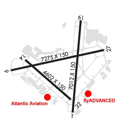 Airport Diagram might not be current. | |
| Facility Name: | NEW CASTLE |
| City Name: | WILMINGTON |
| County: | NEW CASTLE |
| State abbrev: | DE |
| State Name: | DELAWARE |
| Ownership: | PUBLICLY OWNED |
| Use: | OPEN TO THE PUBLIC |
| Owner's Name: | DELAWARE RIVER & BAY AUTHORITY; LEASEE. PROPERTY OWNED BY NEW CASTLE COUNTY 87 READS WAY NEW CASTLE, DE 19720. TEL 302-395-5990. |
| Address: | 151 N. DUPONT HIGHWAY |
| NEW CASTLE, DE 19720-0071 | |
| Owner's Phone: | (302) 571-6445 |
| Manager's Name: | BENJAMIN CLENDANIEL |
| Address: | 151 N. DUPONT HIGHWAY |
| NEW CASTLE, DE 19720-0071 | |
| Phone: | (302) 229-6315 |
| FAA Region: | EASTERN |
| FAA Field Office: | HAR |

| Date | Sunrise | Sunset |
|---|---|---|
| 09/24/21 Friday | 6:52 | 18:57 |
| 09/25/21 Saturday | 6:53 | 18:55 |
| 09/26/21 Sunday | 6:54 | 18:53 |
| 09/27/21 Monday | 6:54 | 18:52 |
| 09/28/21 Tuesday | 6:55 | 18:50 |
| 09/29/21 Wednesday | 6:56 | 18:48 |
| 09/30/21 Thursday | 6:57 | 18:47 |
| 10/01/21 Friday | 6:58 | 18:45 |
| 10/02/21 Saturday | 6:59 | 18:44 |
| 10/03/21 Sunday | 7:00 | 18:42 |
| 10/04/21 Monday | 7:01 | 18:40 |
| 10/05/21 Tuesday | 7:02 | 18:39 |
| 10/06/21 Wednesday | 7:03 | 18:37 |
| 10/07/21 Thursday | 7:04 | 18:36 |
| Airport Attendance Schedule | CONTINUOUS |
| Airport Status | OPERATIONAL (This Status can change at any time - please check NOTAMS) |
| Airport Lighting Schedule | WHEN TWR CLSD ACTVT MALSR RWY 01; REIL RWY 09, 27 & 19; PAPI RWY 09 & 27; HIRL RWY 01/19 & 09/27; MIRL RWY 14/32 - CTAF. |
| Airport Storage Available | Tie Downs, Hanger |
| Extra Services Available | Air Ambulance, Avionics, Cargo Handling, Flight Instruction, Aircraft Rental, Aircraft Sales |
| Wind Indicator | YES - (lighted) |
| Control Tower | YES |
| CTAF Frequency | 126.000 |
| Unicom Frequency | 122.950 |
| Rotating Beacon Color | CLEAR-GREEN (Light Land Airport) |
| Segmented Circle | NO |
| Landing Fee | YES; LNDG FEE FOR ALL ACFT OVER 7500 LBS EXCEPT FEDERAL GOVT; MILITARY. |
| Airport Inspected | FEDERAL - performed by FAA AIRPORTS FIELD PERSONNEL |
| Inspection Date | 01/06/2020 |
| Type of Fuel Available | Grade 100LL, JET A (freeze point -40C) |
| Airframe Repair Service | MAJOR |
| Power Plant Repair Service | MAJOR |
| Latitude | N3940.7 |
| Longitude | W07536.4 (ESTIMATED) |
| Arpt Elevation | 79ft (SURVEYED) |
| Magnetic Variation | 10W |
| 4 miles S | of WILMINGTON |
| Traffic Pattern Altitude | |
| Sectional Chart | WASHINGTON |
| Operations (Reported) | Yearly | Avg. Daily |
|---|---|---|
| General Aviation Transient | 17137 | 47 |
| General Aviation Local | 9118 | 25 |
| Air Taxi | 3010 | 8 |
| Commerical | 20 | 0 |
| Commuter | 0 | 0 |
| Military | 5555 | 15 |
| Aircraft based on Field | |
|---|---|
| General Aviation Singles | 94 |
| General Aviation Multi | 26 |
| Jet Aircraft | 74 |
| General Aviation Helicopters | 5 |
| Military Aircraft | 20 |
| Gliders | 0 |
| Ultralights | 0 |
| FSS on field | NO |
| FSS tie-in | MILLVILLE |
| FSS Phone | 1-800-WX-BRIEF |
| Who issues Notams | ILG |
| Notam D service at airport | YES |
| ARTCC Name | WASHINGTON |
| Airport Certification | AIRPORT RECEIVING SCHEDULED AIR CARRIER SERVICE FROM CARRIERS CERTIFICATED BY THE CIVIL AERONAUTICS BOARD |
| Aircraft Rescue & Firefighting Index | AIRPORT HAS A CERTIFICATE UNDER CFR PART 139 |
| Airport of Entry | No |
| Custom Landing Rights | YES |
| Joint Civil/Military | No |
| Military Landing rights | YES |
| NATIONAL PLAN OF INTEGRATED AIRPORT SYSTEMS (NPIAS) |
| GRANT AGREEMENTS UNDER FAAP/ADAP/AIP |
| AGREEMENT UNDER DLAND OR DCLA HAS EXPIRED. |
| ASSURANCES PURSUANT TO TITLE VI, CIVIL RIGHTS ACT OF 1964 |
| SURPLUS PROPERTY AGREEMENT UNDER PUBLIC LAW 289 |
| COMPLIANCE WITH ACCESSIBILITY TO THE HANDICAPPED |
| RWY 14/32 CLSD TO SKED AIR CARRIER OPS WITH MORE THAN 9 PAX SEATS AND NON SKED AIR CARRIER OPS WITH MORE THAN 30 PAX SEATS EXC FOR TAXI |
| WHEN ATCT CLSD, PILOTS MUST ANNOUNCE INTENTIONS OVER CTAF BEFORE LDGS; TKOFS OR GND TRAVEL ON RYS & TWYS. |
| PVT GND VEHICLES CROSS TWY A BTN TWYS A4 & C. |
| WHEN ATCT CLSD ANNOUNCE EMERGENCIES ON CTAF DIRECTLY TO ARFF STATION. |
| MILITARY: ANG: EXPECT INCR BIRD ACT (INCL WATERFOWL) DUR BASH PHASE II (MAR-MAY & SEP-NOV). CTC CASTLE OPS FOR CURRENT BIRD WATCH COND. |
| TERMINAL APRON CLSD EXCEPT AIR CARRIER. |
| ARNG - OPR 1200-2130Z++ WKD (OPEN ADDN HR FOR SKED TRNG), CLSD SAT, SUN AND HOL. PPR ONLY DSN 440-7205, C302-326-7205. LTD TRAN MAINT, SVC, PRK. CTC GRIFFIN OPS 46.90 10 MIN OUT. |
| BIRDS ON & INVOF ARPT. |
| FOR CD WHEN ATCT IS CLSD CTC PHL APCH AT (800) 354-9884. |
| TRML APRON FENCE LINE 118 FT E OF TWY A CNTRLN. |
| RWY 09/27 NO TGL FOR TURBO JET 2300-0700. |
| TAXILANE 'G' NORTHWEST OF TWY 'H' LTD TO ACFT WITH WINGSPAN OF 79 FT OR LESS. TAXILANE 'G' SECTION BTW TWY 'H' & TWY 'G1' LTD TO ACFT WITH WINGSPAN OF 49 FT OR LESS. |
| RWY 14/3 2 RWY 14/32 NON-STANDARD MILITARY ASSAULT LANDING ZONE (ALZ) LIGHTING. |
Airport Communications & Frequencies:
| |||||||||||||||||||||||||||||||||
| Runway: 01 | Runway: 19 | ||
| Mag heading: | 15° | Mag heading: | 195° |
| Rwy Slope: | -.20% Down | Rwy Slope: | .20% Up |
| Approach: | ILS | Approach: | |
| Pattern: | Left Traffic | Pattern: | Left Traffic |
| Markings: | PRECISION INSTRUMENT | Markings: | PRECISION INSTRUMENT |
| Marking Condition: | GOOD | Marking Condition: | GOOD |
| Arresting Dev: | Arresting Dev: | EMAS; ENGINEERED MATERIAL ARRESTING SYSTEM (EMAS) 303 FT IN LENGTH BY 170 FT IN WIDTH LCTD AT DER 19. | |
| Lat & Long: | N3940.2 W07536.2 | Lat. & Long.: | N3941.3 W07536.1 |
| Elev: | 75.0 ft. MSL | Elev: | 60.9 ft. MSL |
| TCH: | TCH: | 55 ft. AGL | |
| Visual Glide Path: | Visual Glide Path: | 3.00 degrees | |
| Displaced Threshold: | No | Displaced Threshold: | No |
| Touchdown Zone: | YES | Touchdown Zone: | YES |
| Touchdown Elev.: | 75.7 feet | Touchdown Elev.: | 70.7 feet |
| Visual Glide Slope: | Visual Glide Slope: | 4-Light PAPI on LEFT side of Runway | |
| RVR Equipment: | TOUCHDOWN | RVR Equipment: | ROLLOUT |
| RVV Equipment: | NO | RVV Equipment: | NO |
| Approach Lights: | MALSR - 1,400 foot medium intensity approach lighting system with runway alignment indicator lights | Approach Lights: | |
| REIL: | NO | REIL: | YES |
| Centerline Lights: | NO | Centerline Lights: | NO |
| Touchdown lights: | NO | Touchdown lights: | NO |
| Runway Category: | Precision Instrument Runway | Runway Category: | Runway with a Non-precision Approach having visibility minimums greater than 3/4 mile |
| Declared Distances: | TORA:7012' TODA:7012' ASDA:7012' LDA:7012' | Declared Distances: | TORA:7012' TODA:7012' ASDA:7012' LDA:7012' |
| Obstructions: | ROAD | Obstructions: | TREES |
| Marked: | NOT Marked/Lighted | Marked: | NOT Marked/Lighted |
| Clearance slope: | 37:1 | Clearance slope: | 14:1 |
| Obstruction height: | 8 feet AGL | Obstruction height: | 72 feet AGL |
| Dist. from runway: | 500 feet | Dist. from runway: | 1240 feet |
| Centerline offset: | Centerline offset: | 500 feet left of centerline | |
| Comments: | Comments: |
| Runway: 09 | Runway: 27 | ||
| Mag heading: | 88° | Mag heading: | 268° |
| Rwy Slope: | -.12% Down | Rwy Slope: | .12% Up |
| Approach: | MLS | Approach: | |
| Pattern: | Left Traffic | Pattern: | Left Traffic |
| Markings: | PRECISION INSTRUMENT | Markings: | NONPRECISION INSTRUMENT |
| Marking Condition: | GOOD | Marking Condition: | GOOD |
| Arresting Dev: | Arresting Dev: | ||
| Lat & Long: | N3940.7 W07537.2 | Lat. & Long.: | N3940.9 W07535.7 |
| Elev: | 79.8 ft. MSL | Elev: | 71.3 ft. MSL |
| TCH: | 61 ft. AGL | TCH: | 54 ft. AGL |
| Visual Glide Path: | 3.00 degrees | Visual Glide Path: | 3.00 degrees |
| Displaced Threshold: | No | Displaced Threshold: | No |
| Touchdown Zone: | YES | Touchdown Zone: | YES |
| Touchdown Elev.: | 79.9 feet | Touchdown Elev.: | 71.5 feet |
| Visual Glide Slope: | 4-Light PAPI on LEFT side of Runway | Visual Glide Slope: | 4-Light PAPI on LEFT side of Runway |
| RVR Equipment: | RVR Equipment: | ||
| RVV Equipment: | NO | RVV Equipment: | NO |
| Approach Lights: | Approach Lights: | ||
| REIL: | YES | REIL: | YES |
| Centerline Lights: | NO | Centerline Lights: | NO |
| Touchdown lights: | NO | Touchdown lights: | NO |
| Runway Category: | Runway with a Non-precision Approach having visibility minimums greater than 3/4 mile | Runway Category: | Runway with a Non-precision Approach having visibility minimums greater than 3/4 mile |
| Declared Distances: | TORA:7275' TODA:7275' ASDA:7000' LDA:7000' | Declared Distances: | TORA:7275' TODA:7275' ASDA:7000' LDA:7000' |
| Obstructions: | TREES | Obstructions: | TREES |
| Marked: | NOT Marked/Lighted | Marked: | NOT Marked/Lighted |
| Clearance slope: | 18:1 | Clearance slope: | 12:1 |
| Obstruction height: | 49 feet AGL | Obstruction height: | 64 feet AGL |
| Dist. from runway: | 1125 feet | Dist. from runway: | 1000 feet |
| Centerline offset: | 600 left of centerline | Centerline offset: | 75B |
| Comments: | Comments: |
| Runway: 14 | Runway: 32 | ||
| Mag heading: | 141° | Mag heading: | 321° |
| Rwy Slope: | -.02% Down | Rwy Slope: | .02% Up |
| Approach: | Approach: | ||
| Pattern: | Left Traffic | Pattern: | Left Traffic |
| Markings: | BASIC | Markings: | BASIC |
| Marking Condition: | GOOD | Marking Condition: | GOOD |
| Arresting Dev: | Arresting Dev: | ||
| Lat & Long: | N3940.8 W07537.0 | Lat. & Long.: | N3940.3 W07536.3 |
| Elev: | 75.3 ft. MSL | Elev: | 74.2 ft. MSL |
| TCH: | TCH: | 28 ft. AGL | |
| Visual Glide Path: | Visual Glide Path: | 3.00 degrees | |
| Displaced Threshold: | No | Displaced Threshold: | No |
| Touchdown Zone: | YES | Touchdown Zone: | YES |
| Touchdown Elev.: | 76.0 feet | Touchdown Elev.: | 75.6 feet |
| Visual Glide Slope: | Visual Glide Slope: | 4-BOX VASI ON LEFT SIDE OF RUNWAY | |
| RVR Equipment: | RVR Equipment: | ||
| RVV Equipment: | NO | RVV Equipment: | NO |
| Approach Lights: | Approach Lights: | ||
| REIL: | NO | REIL: | NO |
| Centerline Lights: | NO | Centerline Lights: | NO |
| Touchdown lights: | NO | Touchdown lights: | NO |
| Runway Category: | Runway with a Visual Approach | Runway Category: | Runway with a Visual Approach |
| Declared Distances: | TORA:4602' TODA:4602' ASDA:4602' LDA:4602' | Declared Distances: | TORA:4602' TODA:4602' ASDA:4602' LDA:4602' |
| Obstructions: | TREES | Obstructions: | |
| Marked: | NOT Marked/Lighted | Marked: | |
| Clearance slope: | 12:1 | Clearance slope: | 50:1 |
| Obstruction height: | 43 feet AGL | Obstruction height: | |
| Dist. from runway: | 720 feet | Dist. from runway: | |
| Centerline offset: | 200 left of centerline | Centerline offset: | |
| Comments: | Comments: |
Thanks for using FltPlan.com
all rights reserved © 1999-2021 by Flight Plan LLC