| CONCORD RGNL CONCORD NC |
| |
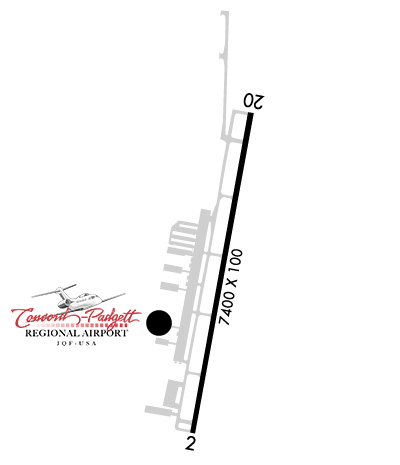
| Lat: N 3523.3 Long: W 08042.5 Elev: 704 Var: +06 Longest Runway: 7402 | ||
| Clr Del: 127.25/118.55 Dept. ATIS: 133.67 Arr. ATIS: 133.67 AWOS: 133.67 Ground: 121.85 Tower: 134.65 | ||
| |||||||||||||||||||||||||||||||||||||||||||||||||||||||||||||||||||||
| |||||||||||||||||||||||||||||||||||||||||||||||||||||||||||||||||||||
| |||||||||||||||||||||||||||||||||||||||||||||||||||||||||||||||||||||
| FBOs at nearby airports who want your business: | |||||||||||||||||
| |||||||||||||||||
| |||||||||||||||||
| Rwy | Rwy | |||||||
| 7402x100 | 7402' | 7402x100 | 6752' | 111.95 - 196° | ||||
| Runway ID | Single Wheel | Double Wheel | Double Tandem Wheel | Dual Double Wheel |
| 02/20 | N/A | 171,000 | N/A | N/A |
| H1 | N/A | N/A | N/A | N/A |
| These numbers are Advisory and are not limits. The Airport Manager should have more accurate Weight Limits | ||||
 Airport Diagram might not be current. | |
| Facility Name: | CONCORD-PADGETT RGNL |
| City Name: | CONCORD |
| County: | CABARRUS |
| State abbrev: | NC |
| State Name: | NORTH CAROLINA |
| Ownership: | PUBLICLY OWNED |
| Use: | OPEN TO THE PUBLIC |
| Owner's Name: | CITY OF CONCORD |
| Address: | 9000 AVIATION BLVD |
| CONCORD, NC 28027 | |
| Owner's Phone: | 704-920-5900 |
| Manager's Name: | DANNY JACOBS |
| Address: | 9000 AVIATION BLVD |
| CONCORD, NC 28027 | |
| Phone: | (704) 920-5941 |
| FAA Region: | SOUTHERN |
| FAA Field Office: | MEM |

| Date | Sunrise | Sunset |
|---|---|---|
| 04/22/25 Tuesday | 6:42 | 20:01 |
| 04/23/25 Wednesday | 6:41 | 20:02 |
| 04/24/25 Thursday | 6:40 | 20:03 |
| 04/25/25 Friday | 6:38 | 20:04 |
| 04/26/25 Saturday | 6:37 | 20:05 |
| 04/27/25 Sunday | 6:36 | 20:05 |
| 04/28/25 Monday | 6:35 | 20:06 |
| 04/29/25 Tuesday | 6:34 | 20:07 |
| 04/30/25 Wednesday | 6:33 | 20:08 |
| 05/01/25 Thursday | 6:32 | 20:09 |
| 05/02/25 Friday | 6:31 | 20:10 |
| 05/03/25 Saturday | 6:30 | 20:10 |
| 05/04/25 Sunday | 6:28 | 20:11 |
| 05/05/25 Monday | 6:27 | 20:12 |
| Airport Attendance Schedule | CONTINUOUS |
| Airport Status | OPERATIONAL (This Status can change at any time - please check NOTAMS) |
| Airport Lighting Schedule | WHEN ATCT CLSD; TDZL RWY 20; HIRL RWY 02/20 & REIL RWY 02 PRESET LOW INTST. ACTVT MALSR RWY 20; REIL RWY 02; TDZL RWY 20; HIRL RWY 02/20 - CTAF. PAPI RWY 02 & 20 OPER CONSLY. |
| Airport Storage Available | Tie Downs, Hanger |
| Extra Services Available | Avionics, Charter, Flight Instruction, Aircraft Rental, Aircraft Sales |
| Wind Indicator | YES - (lighted) |
| Control Tower | YES |
| CTAF Frequency | 134.650 |
| Unicom Frequency | 122.950 |
| Rotating Beacon Color | WG |
| Segmented Circle | YES |
| Landing Fee |
| Airport Inspected | STATE - performed by FAA AIRPORTS FIELD PERSONNEL |
| Inspection Date | 08/16/2024 |
| Type of Fuel Available | Grade 100LL, JET A (freeze point -40C), JET A-1 (icing inhibitor, freeze point -50C) |
| Airframe Repair Service | MAJOR |
| Power Plant Repair Service | MAJOR |
| Latitude | N3523.3 |
| Longitude | W08042.5 (ESTIMATED) |
| Arpt Elevation | 704ft (SURVEYED) |
| Magnetic Variation | 06W |
| 7 miles W | of CONCORD |
| Traffic Pattern Altitude | |
| Sectional Chart | CHARLOTTE |
| Operations (Reported) | Yearly | Avg. Daily |
|---|---|---|
| General Aviation Transient | 0 | 0 |
| General Aviation Local | 0 | 0 |
| Air Taxi | 0 | 0 |
| Commerical | 0 | 0 |
| Commuter | 0 | 0 |
| Military | 0 | 0 |
| Aircraft based on Field | |
|---|---|
| General Aviation Singles | 0 |
| General Aviation Multi | 0 |
| Jet Aircraft | 0 |
| General Aviation Helicopters | 0 |
| Military Aircraft | 0 |
| Gliders | 0 |
| Ultralights | 0 |
| FSS on field | NO |
| FSS tie-in | RALEIGH |
| FSS Phone | 1-800-WX-BRIEF |
| Who issues Notams | JQF |
| Notam D service at airport | YES |
| ARTCC Name | ATLANTA |
| Airport Certification | AIRPORT RECEIVING SCHEDULED AIR CARRIER SERVICE FROM CARRIERS CERTIFICATED BY THE CIVIL AERONAUTICS BOARD |
| Aircraft Rescue & Firefighting Index | AIRPORT HAS A CERTIFICATE UNDER CFR PART 139 |
| Airport of Entry | No |
| Custom Landing Rights | No |
| Joint Civil/Military | No |
| Military Landing rights | No |
| NATIONAL PLAN OF INTEGRATED AIRPORT SYSTEMS (NPIAS) |
| GRANT AGREEMENTS UNDER FAAP/ADAP/AIP |
| ASSURANCES PURSUANT TO TITLE VI, CIVIL RIGHTS ACT OF 1964 |
| FOR CD WHEN ATCT IS CLSD CTC CLT APCH AT 704-359-0241. |
| RWY 02/2 0 GROOVED FULL LENGTH ASPHALT. |
| RWY 02/2 0 PCR VALUE: 450/F/D/X/T |
Airport Communications & Frequencies:
| ||||||||||||||||||||||||
| Runway: 02 | Runway: 20 | ||
| Mag heading: | 16° | Mag heading: | 196° |
| Rwy Slope: | .88% Up | Rwy Slope: | -.88% Down |
| Approach: | Approach: | ILS/DME | |
| Pattern: | Left Traffic | Pattern: | Left Traffic |
| Markings: | PRECISION INSTRUMENT | Markings: | PRECISION INSTRUMENT |
| Marking Condition: | GOOD | Marking Condition: | GOOD |
| Arresting Dev: | Arresting Dev: | ||
| Lat & Long: | N3522.7 W08042.7 | Lat. & Long.: | N3523.9 W08042.4 |
| Elev: | 639.4 ft. MSL | Elev: | 704.2 ft. MSL |
| TCH: | 69 ft. AGL | TCH: | 45 ft. AGL |
| Visual Glide Path: | 3.50 degrees | Visual Glide Path: | 3.00 degrees |
| Displaced Threshold: | No | Displaced Threshold: | 650 feet |
| Touchdown Zone: | YES | Touchdown Zone: | YES |
| Touchdown Elev.: | 666.9 feet | Touchdown Elev.: | 699.1 feet |
| Visual Glide Slope: | 4-Light PAPI on LEFT side of Runway | Visual Glide Slope: | 4-Light PAPI on LEFT side of Runway |
| RVR Equipment: | RVR Equipment: | ||
| RVV Equipment: | NO | RVV Equipment: | NO |
| Approach Lights: | Approach Lights: | MALSR - 1,400 foot medium intensity approach lighting system with runway alignment indicator lights | |
| REIL: | YES | REIL: | NO |
| Centerline Lights: | NO | Centerline Lights: | NO |
| Touchdown lights: | NO | Touchdown lights: | YES |
| Runway Category: | Runway with a Non-precision Approach having visibility minimums greater than 3/4 mile | Runway Category: | Precision Instrument Runway |
| Declared Distances: | TORA:7400' TODA:7400' ASDA:7400' LDA:7400' | Declared Distances: | TORA:7400' TODA:7400' ASDA:7000' LDA:6350' |
| Obstructions: | TREES | Obstructions: | TREES |
| Marked: | NOT Marked/Lighted | Marked: | NOT Marked/Lighted |
| Clearance slope: | 6:1 | Clearance slope: | 23:1 |
| Obstruction height: | 13 feet AGL | Obstruction height: | 127 feet AGL |
| Dist. from runway: | 281 feet | Dist. from runway: | 3200 feet |
| Centerline offset: | 248 left of centerline | Centerline offset: | 500 feet right of centerline |
| Comments: | Comments: |
Thanks for using FltPlan.com
all rights reserved © 1999-2025 by Flight Plan LLC